canton of Rosières-en-Santerre (canton de Rosières-en-Santerre)
- canton of France
- Country:

- Capital: Rosières-en-Santerre
- Coordinates: 49° 48' 54" N, 2° 42' 11" E


- GPS tracks (wikiloc): [Link]
- Wikipedia en: wiki(en)
- Wikipedia: wiki(fr)
- Wikidata storage: Wikidata: Q1727008
- Freebase ID: [/m/03y1pxy]
- INSEE canton code: [8037]
Includes regions:


Caix
- commune in Somme, France
- Country:
- Postal Code: 80170
- Coordinates: 49° 49' 0" N, 2° 38' 45" E
- GPS tracks (wikiloc): [Link]
- Area: 11.95 sq km
- Population: 762
- Web site: [Link]

Beaufort-en-Santerre
- commune in Somme, France
- Country:
- Postal Code: 80170
- Coordinates: 49° 46' 32" N, 2° 40' 7" E
- GPS tracks (wikiloc): [Link]
- Area: 4.59 sq km
- Population: 203


Rosières-en-Santerre
- commune in Somme, France
- Country:
- Postal Code: 80170
- Coordinates: 49° 48' 51" N, 2° 42' 10" E
- GPS tracks (wikiloc): [Link]
- Area: 12.98 sq km
- Population: 3007
- Web site: [Link]


Guillaucourt
- commune in Somme, France
- Country:
- Postal Code: 80170
- Coordinates: 49° 50' 31" N, 2° 37' 52" E
- GPS tracks (wikiloc): [Link]
- Area: 6.37 sq km
- Population: 422


Fransart
- commune in Somme, France
- Country:
- Postal Code: 80700
- Coordinates: 49° 46' 2" N, 2° 46' 24" E
- GPS tracks (wikiloc): [Link]
- Area: 3 sq km
- Population: 148
- Web site: [Link]


Folies
- commune in Somme, France
- Country:
- Postal Code: 80170
- Coordinates: 49° 45' 38" N, 2° 40' 18" E
- GPS tracks (wikiloc): [Link]
- Area: 5.63 sq km
- Population: 139


Fouquescourt
- commune in Somme, France
- Country:
- Postal Code: 80170
- Coordinates: 49° 46' 11" N, 2° 45' 7" E
- GPS tracks (wikiloc): [Link]
- Area: 5.45 sq km
- Population: 171
- Web site: [Link]

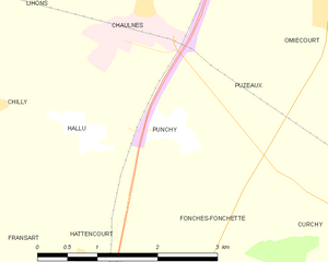
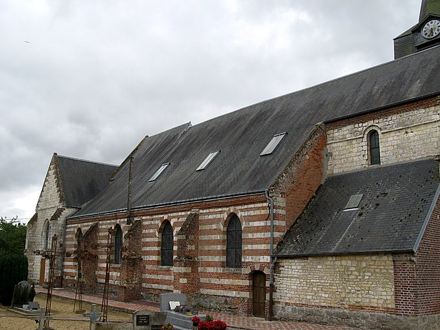
Punchy
- commune in Somme, France
- Country:
- Postal Code: 80320
- Coordinates: 49° 47' 31" N, 2° 48' 36" E
- GPS tracks (wikiloc): [Link]
- Area: 3.04 sq km
- Population: 85

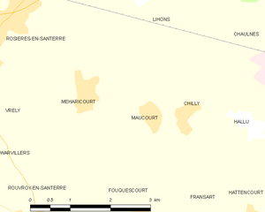
Maucourt
- commune in Somme, France
- Country:
- Postal Code: 80170
- Coordinates: 49° 47' 38" N, 2° 45' 16" E
- GPS tracks (wikiloc): [Link]
- AboveSeaLevel: 91 м m
- Area: 3.68 sq km
- Population: 175


Méharicourt
- commune in Somme, France
- Country:
- Postal Code: 80170
- Coordinates: 49° 47' 55" N, 2° 43' 55" E
- GPS tracks (wikiloc): [Link]
- Area: 7.01 sq km
- Population: 579


Bayonvillers
- commune in Somme, France
- Country:
- Postal Code: 80170
- Coordinates: 49° 51' 41" N, 2° 37' 37" E
- GPS tracks (wikiloc): [Link]
- Area: 8.1 sq km
- Population: 351


Parvillers-le-Quesnoy
- commune in Somme, France
- Country:
- Postal Code: 80700
- Coordinates: 49° 44' 48" N, 2° 44' 19" E
- GPS tracks (wikiloc): [Link]
- AboveSeaLevel: 101 м m
- Area: 9.5 sq km
- Population: 238


Vrély
- commune in Somme, France
- Country:
- Postal Code: 80170
- Coordinates: 49° 47' 53" N, 2° 41' 35" E
- GPS tracks (wikiloc): [Link]
- Area: 5.66 sq km
- Population: 436


La Chavatte
- commune in Somme, France
- Country:
- Postal Code: 80700
- Coordinates: 49° 45' 25" N, 2° 46' 0" E
- GPS tracks (wikiloc): [Link]
- Area: 1.89 sq km
- Population: 74

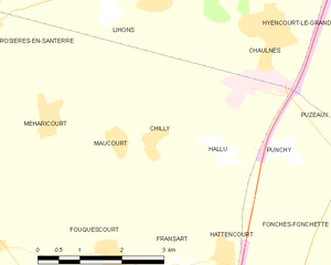
Chilly
- commune in Somme, France
- Country:
- Postal Code: 80170
- Coordinates: 49° 47' 39" N, 2° 46' 1" E
- GPS tracks (wikiloc): [Link]
- Area: 4.85 sq km
- Population: 188


Bouchoir
- commune in Somme, France
- Country:
- Postal Code: 80910
- Coordinates: 49° 44' 55" N, 2° 40' 25" E
- GPS tracks (wikiloc): [Link]
- Area: 5.88 sq km
- Population: 318
- Web site: [Link]


Hallu
- commune in Somme, France
- Country:
- Postal Code: 80320
- Coordinates: 49° 47' 34" N, 2° 47' 20" E
- GPS tracks (wikiloc): [Link]
- Area: 3.85 sq km
- Population: 189


Rouvroy-en-Santerre
- commune in Somme, France
- Country:
- Postal Code: 80170
- Coordinates: 49° 46' 8" N, 2° 42' 32" E
- GPS tracks (wikiloc): [Link]
- Area: 7.35 sq km
- Population: 209

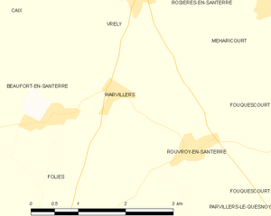
Warvillers
- commune in Somme, France
- Country:
- Postal Code: 80170
- Coordinates: 49° 46' 47" N, 2° 41' 14" E
- GPS tracks (wikiloc): [Link]
- Area: 4.18 sq km
- Population: 147

Harbonnières
- commune in Somme, France
- Country:
- Postal Code: 80131
- Coordinates: 49° 50' 56" N, 2° 40' 11" E
- GPS tracks (wikiloc): [Link]
- Area: 15.37 sq km
- Population: 1648