Méharicourt (Méharicourt)

- commune in Somme, France
- Country:

- Postal Code: 80170
- Coordinates: 49° 47' 55" N, 2° 43' 55" E


- GPS tracks (wikiloc): [Link]
- Area: 7.01 sq km
- Population: 579
- Wikipedia en: wiki(en)
- Wikipedia: wiki(fr)
- Wikidata storage: Wikidata: Q396847
- Wikipedia Commons Category: [Link]
- Freebase ID: [/m/03qmq3r]
- GeoNames ID: Alt: [6444603]
- SIREN number: [218004976]
- BnF ID: [152770021]
- INSEE municipality code: 80524
Shares border with regions:


Rosières-en-Santerre
- commune in Somme, France
- Country:
- Postal Code: 80170
- Coordinates: 49° 48' 51" N, 2° 42' 10" E
- GPS tracks (wikiloc): [Link]
- Area: 12.98 sq km
- Population: 3007
- Web site: [Link]


Lihons
- commune in Somme, France
- Country:
- Postal Code: 80320
- Coordinates: 49° 49' 27" N, 2° 45' 58" E
- GPS tracks (wikiloc): [Link]
- Area: 12.42 sq km
- Population: 423
- Web site: [Link]


Fouquescourt
- commune in Somme, France
- Country:
- Postal Code: 80170
- Coordinates: 49° 46' 11" N, 2° 45' 7" E
- GPS tracks (wikiloc): [Link]
- Area: 5.45 sq km
- Population: 171
- Web site: [Link]

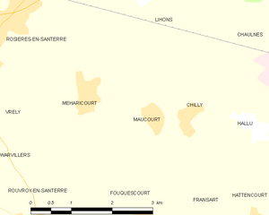
Maucourt
- commune in Somme, France
- Country:
- Postal Code: 80170
- Coordinates: 49° 47' 38" N, 2° 45' 16" E
- GPS tracks (wikiloc): [Link]
- AboveSeaLevel: 91 м m
- Area: 3.68 sq km
- Population: 175


Vrély
- commune in Somme, France
- Country:
- Postal Code: 80170
- Coordinates: 49° 47' 53" N, 2° 41' 35" E
- GPS tracks (wikiloc): [Link]
- Area: 5.66 sq km
- Population: 436


Rouvroy-en-Santerre
- commune in Somme, France
- Country:
- Postal Code: 80170
- Coordinates: 49° 46' 8" N, 2° 42' 32" E
- GPS tracks (wikiloc): [Link]
- Area: 7.35 sq km
- Population: 209

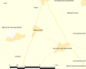
Warvillers
- commune in Somme, France
- Country:
- Postal Code: 80170
- Coordinates: 49° 46' 47" N, 2° 41' 14" E
- GPS tracks (wikiloc): [Link]
- Area: 4.18 sq km
- Population: 147