canton of Senlis (canton de Senlis)

- canton of France
- Country:

- Capital: Senlis
- Coordinates: 49° 11' 8" N, 2° 35' 7" E


- GPS tracks (wikiloc): [Link]
- Population: 32103
- Wikipedia en: wiki(en)
- Wikipedia: wiki(fr)
- Wikidata storage: Wikidata: Q1727476
- Library of Congress authority ID: Alt: [n82153952]
- INSEE canton code: [6020]
Includes regions:


La Chapelle-en-Serval
- commune in Oise, France
- Country:
- Postal Code: 60520
- Coordinates: 49° 7' 39" N, 2° 32' 4" E
- GPS tracks (wikiloc): [Link]
- Area: 10.81 sq km
- Population: 2944
- Web site: [Link]


Chamant
- commune in Oise, France
- Country:
- Postal Code: 60300
- Coordinates: 49° 13' 11" N, 2° 36' 39" E
- GPS tracks (wikiloc): [Link]
- Area: 12 sq km
- Population: 908
- Web site: [Link]


Aumont-en-Halatte
- commune in Oise, France
- Country:
- Postal Code: 60300
- Coordinates: 49° 14' 0" N, 2° 33' 0" E
- GPS tracks (wikiloc): [Link]
- AboveSeaLevel: 99 м m
- Area: 6.83 sq km
- Population: 503

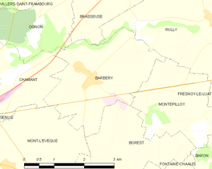
Barbery
- commune in Oise, France
- Country:
- Postal Code: 60810
- Coordinates: 49° 13' 21" N, 2° 40' 7" E
- GPS tracks (wikiloc): [Link]
- Area: 7.6 sq km
- Population: 562


Mont-l'Évêque
- commune in Oise, France
- Country:
- Postal Code: 60300
- Coordinates: 49° 11' 41" N, 2° 37' 51" E
- GPS tracks (wikiloc): [Link]
- Area: 14.18 sq km
- Population: 410
- Web site: [Link]


Senlis
- commune in Oise, France
- Country:
- Postal Code: 60300
- Coordinates: 49° 12' 26" N, 2° 35' 12" E
- GPS tracks (wikiloc): [Link]
- AboveSeaLevel: 76 м m
- Area: 24.05 sq km
- Population: 14777
- Web site: [Link]


Villers-Saint-Frambourg
- commune in Oise, France
- Country:
- Postal Code: 60810
- Coordinates: 49° 15' 19" N, 2° 38' 21" E
- GPS tracks (wikiloc): [Link]
- Area: 9.72 sq km
- Population: 558
- Web site: [Link]

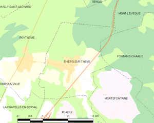
Thiers-sur-Thève
- commune in Oise, France
- Country:
- Postal Code: 60520
- Coordinates: 49° 9' 8" N, 2° 34' 19" E
- GPS tracks (wikiloc): [Link]
- Area: 6.25 sq km
- Population: 1037


Plailly
- commune in Oise, France
- Country:
- Postal Code: 60128
- Coordinates: 49° 6' 12" N, 2° 35' 1" E
- GPS tracks (wikiloc): [Link]
- Area: 16.25 sq km
- Population: 1703
- Web site: [Link]

Mortefontaine
- commune in Oise, France
- Country:
- Postal Code: 60128
- Coordinates: 49° 6' 45" N, 2° 35' 58" E
- GPS tracks (wikiloc): [Link]
- Area: 15.29 sq km
- Population: 837


Pontarmé
- commune in Oise, France
- Country:
- Postal Code: 60520
- Coordinates: 49° 9' 11" N, 2° 32' 58" E
- GPS tracks (wikiloc): [Link]
- Area: 13.24 sq km
- Population: 818
- Web site: [Link]


Ognon
- commune in Oise, France
- Country:
- Postal Code: 60810
- Coordinates: 49° 14' 11" N, 2° 38' 36" E
- GPS tracks (wikiloc): [Link]
- Area: 4.82 sq km
- Population: 156
- Web site: [Link]


Montépilloy
- commune in Oise, France
- Country:
- Postal Code: 60810
- Coordinates: 49° 12' 33" N, 2° 41' 53" E
- GPS tracks (wikiloc): [Link]
- Area: 5.86 sq km
- Population: 153


Avilly-Saint-Léonard
- commune in Oise, France
- Country:
- Postal Code: 60300
- Coordinates: 49° 11' 38" N, 2° 32' 11" E
- GPS tracks (wikiloc): [Link]
- Area: 11.96 sq km
- Population: 884
- Web site: [Link]


Vineuil-Saint-Firmin
- commune in Oise, France
- Country:
- Postal Code: 60500
- Coordinates: 49° 12' 0" N, 2° 29' 32" E
- GPS tracks (wikiloc): [Link]
- Area: 7.78 sq km
- Population: 1369


Courteuil
- commune in Oise, France
- Country:
- Postal Code: 60300
- Coordinates: 49° 11' 56" N, 2° 32' 6" E
- GPS tracks (wikiloc): [Link]
- Area: 5.32 sq km
- Population: 624


Orry-la-Ville
- commune in Oise, France
- Country:
- Postal Code: 60560
- Coordinates: 49° 7' 56" N, 2° 30' 46" E
- GPS tracks (wikiloc): [Link]
- Area: 12.1 sq km
- Population: 3384