canton of Taverny (canton de Taverny)

- canton of France
- Country:

- Capital: Taverny
- Coordinates: 49° 2' 0" N, 2° 13' 0" E


- GPS tracks (wikiloc): [Link]
- Population: 49751
- Wikipedia en: wiki(en)
- Wikipedia: wiki(fr)
- Wikidata storage: Wikidata: Q786952
- INSEE canton code: [9519]
Includes regions:


Chauvry
- commune in Val-d'Oise, France
- Country:
- Postal Code: 95560
- Coordinates: 49° 3' 14" N, 2° 16' 1" E
- GPS tracks (wikiloc): [Link]
- Area: 5 sq km
- Population: 305
- Web site: [Link]

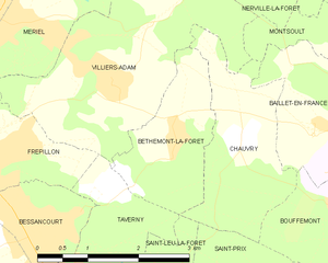
Béthemont-la-Forêt
- commune in Val-d'Oise, France
- Country:
- Postal Code: 95840
- Coordinates: 49° 3' 17" N, 2° 15' 10" E
- GPS tracks (wikiloc): [Link]
- Area: 3.79 sq km
- Population: 428


Bessancourt
- commune in Val-d'Oise, France
- Country:
- Postal Code: 95550
- Coordinates: 49° 2' 16" N, 2° 12' 48" E
- GPS tracks (wikiloc): [Link]
- Area: 6.39 sq km
- Population: 6811
- Web site: [Link]

Taverny
- commune in Val-d'Oise, France
- Country:
- Postal Code: 95150
- Coordinates: 49° 1' 33" N, 2° 13' 36" E
- GPS tracks (wikiloc): [Link]
- Area: 10.48 sq km
- Population: 26077
- Web site: [Link]


Frépillon
- commune in Val-d'Oise, France
- Country:
- Postal Code: 95740
- Coordinates: 49° 3' 6" N, 2° 12' 18" E
- GPS tracks (wikiloc): [Link]
- Area: 3.35 sq km
- Population: 3310
- Web site: [Link]
Shares border with regions:
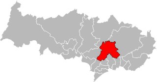
canton of Domont
- canton of France
- Country:
- Capital: Domont
- Coordinates: 49° 2' 0" N, 2° 20' 0" E
- GPS tracks (wikiloc): [Link]
- Population: 60615