Capo di Ponte (Capo di Ponte)
.svg)
- Italian comune
 Hiking in Capo di Ponte
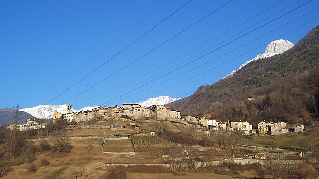
Capo di Ponte, located in the province of Brescia in the Lombardy region of northern Italy, is known for its stunning landscapes and rich cultural heritage. The area is part of the larger Adamello Regional Park, which offers a variety of hiking trails suitable for all levels of hikers.
Highlights of Hiking in Capo di Ponte:
-
Rock Engravings: One of the most significant features of the area is the archaeological site of Naquane Park, where you can find prehistoric rock engravings that date back to the Iron Age. These engravings provide a fascinating insight into the region's ancient history.
-
Variety of Trails: There are numerous trails that range from easy walks to more challenging hikes. Popular trails include the path to the scenic viewpoint over the valley and routes that lead you through lush forests and alongside the rivers.
-
Panoramic Views: The hikes in Capo di Ponte often reward you with breathtaking views of the surrounding mountains and valleys. The diverse terrain includes forests, meadows, and rocky outcrops.
-
Wildlife and Flora: While hiking, you may encounter a variety of wildlife, including deer, foxes, and numerous bird species. The area is also rich in flora, featuring alpine plants and wildflowers, especially during the spring and summer months.
-
Cultural Experiences: Along your hike, you can explore traditional villages and sample local cuisine. The area's cultural heritage adds a unique dimension to your hiking experience.
Practical Tips:
- Best Time to Visit: Late spring (May-June) and early autumn (September-October) are ideal for hiking, as the weather is generally mild and the trails are less crowded.
- Gear: Wear sturdy hiking boots and bring water, snacks, a map, and sunscreen. Depending on the season, layers may be necessary due to changing temperatures.
- Guided Tours: If you're unfamiliar with the area, consider joining a guided tour to gain insights into the local history and geology of the region.
Hiking in Capo di Ponte offers a perfect blend of natural beauty, cultural richness, and physical activity, making it a rewarding experience for outdoor enthusiasts.
- Country:

- Postal Code: 25044
- Local Dialing Code: 0364
- Licence Plate Code: BS
- Coordinates: 46° 1' 54" N, 10° 20' 46" E


- GPS tracks (wikiloc): [Link]
- AboveSeaLevel: 362 м m
- Area: 18.11 sq km
- Population: 2471
- Web site: http://www.comune.capo-di-ponte.bs.it/
- Wikipedia en: wiki(en)
- Wikipedia: wiki(it)
- Wikidata storage: Wikidata: Q103739
- Wikipedia Commons Gallery: [Link]
- Wikipedia Commons Category: [Link]
- Freebase ID: [/m/041prz]
- GeoNames ID: Alt: [6537164]
- VIAF ID: Alt: [141879841]
- OSM relation ID: [46739]
- WOEID: [712111]
- ISTAT ID: 017035
- Italian cadastre code: B664
Shares border with regions:

Cedegolo
- Italian comune
Hiking in Cedegolo
Cedegolo, located in the Lombardy region of Italy, offers beautiful hiking opportunities primarily situated within the scenic boundaries of the Adamello Regional Park. The area is known for its stunning landscapes, diverse flora and fauna, and a rich network of trails suited for various skill levels. Here are some highlights of hiking in Cedegolo:...
- Country:
- Postal Code: 25051
- Local Dialing Code: 0364
- Licence Plate Code: BS
- Coordinates: 46° 4' 39" N, 10° 21' 2" E
- GPS tracks (wikiloc): [Link]
- AboveSeaLevel: 413 м m
- Area: 11.08 sq km
- Population: 1173
- Web site: [Link]
Ceto, Lombardy
- Italian comune
Hiking in Ceto, Lombardy
Ceto, located in the northern Italian region of Lombardy, is a hidden gem for hiking enthusiasts. Nestled in the Val Camonica, this area is known for its stunning landscapes, rich natural beauty, and historical significance. Here are some highlights and tips for hiking in Ceto:...
- Country:
- Postal Code: 25040
- Local Dialing Code: 0364
- Licence Plate Code: BS
- Coordinates: 46° 0' 12" N, 10° 21' 10" E
- GPS tracks (wikiloc): [Link]
- AboveSeaLevel: 453 м m
- Area: 32.3 sq km
- Population: 1886
- Web site: [Link]

Cimbergo
- Italian comune
Hiking in Cimbergo
Cimbergo, located in the Lombardy region of Italy, is known for its beautiful landscapes and historical significance, which make it an attractive destination for hikers and outdoor enthusiasts. Here are some key points about hiking in Cimbergo:...
- Country:
- Postal Code: 25050
- Local Dialing Code: 0364
- Licence Plate Code: BS
- Coordinates: 46° 1' 30" N, 10° 22' 0" E
- GPS tracks (wikiloc): [Link]
- AboveSeaLevel: 850 м m
- Area: 24.71 sq km
- Population: 539
- Web site: [Link]

Ono San Pietro
- Italian comune
Hiking in Ono San Pietro
Ono San Pietro is a charming municipality located in the province of Brescia in northern Italy, surrounded by the stunning landscape of the Italian Alps. It's an excellent destination for hiking enthusiasts, offering access to various trails that showcase the region's natural beauty....
- Country:
- Postal Code: 25050
- Local Dialing Code: 0364
- Licence Plate Code: BS
- Coordinates: 46° 1' 4" N, 10° 19' 45" E
- GPS tracks (wikiloc): [Link]
- AboveSeaLevel: 516 м m
- Area: 13.78 sq km
- Population: 972
- Web site: [Link]

Paisco Loveno
- Italian comune
Hiking in Paisco Loveno
Paisco Loveno is a picturesque location nestled in the Italian Alps, particularly known for its breathtaking landscapes and diverse hiking trails. Here are some key points to consider if you're planning a hiking trip there:...
- Country:
- Postal Code: 25050
- Local Dialing Code: 0364
- Licence Plate Code: BS
- Coordinates: 46° 4' 48" N, 10° 17' 36" E
- GPS tracks (wikiloc): [Link]
- AboveSeaLevel: 853 м m
- Area: 35.87 sq km
- Population: 190
- Web site: [Link]

Paspardo
- Italian comune
Hiking in Paspardo
Paspardo is a charming village located in the Val Camonica region of northern Italy, known for its beautiful landscapes and opportunities for hiking. The surrounding mountains and valleys offer various trails for hikers of all skill levels. Here are some key points to consider when hiking in the Paspardo area:...
- Country:
- Postal Code: 25050
- Local Dialing Code: 0364
- Licence Plate Code: BS
- Coordinates: 46° 1' 54" N, 10° 22' 19" E
- GPS tracks (wikiloc): [Link]
- AboveSeaLevel: 978 м m
- Area: 11.15 sq km
- Population: 600
- Web site: [Link]

Sellero
- Italian comune
Hiking in Sellero
Sellero is a picturesque village located in the Lombardy region of Italy, nestled among the Tuscan-Emilian Apennines. It's an excellent destination for outdoor enthusiasts who enjoy hiking and exploring nature....
- Country:
- Postal Code: 25050
- Local Dialing Code: 0364
- Licence Plate Code: BS
- Coordinates: 46° 3' 21" N, 10° 20' 52" E
- GPS tracks (wikiloc): [Link]
- AboveSeaLevel: 376 м m
- Area: 14.47 sq km
- Population: 1441
- Web site: [Link]