Capurso (Capurso)
.svg)
- Italian comune
 Hiking in Capurso
Capurso is a charming town located in the Apulia region of southern Italy, known for its rich history and beautiful landscapes. While it may not be a major hiking destination like some mountainous areas, it can serve as a great base for exploring the surrounding countryside and enjoying lighter trails. Here are some aspects to consider when hiking in and around Capurso:
Local Trails
-
Countryside Paths: Capurso is surrounded by picturesque countryside, including olive groves and vineyards. Look for pathways that allow you to walk through these areas, enjoying the scenic views and fresh air.
-
Nearby Parks: The nearby Parco dei Trazzieri offers peaceful trails that can be explored on foot. It’s a great place for both gentle walks and more vigorous hikes.
-
Coastal Hikes: While Capurso itself isn’t directly on the coast, it’s not far from the Adriatic Sea. Consider planning a day hike that takes you to nearby coastal towns like Bari or Monopoli, where you can enjoy waterfront trails.
Tips for Hiking in Capurso
-
Weather Considerations: The best time to hike here is during the spring and fall when the temperatures are mild and pleasant. Summers can get hot, so be sure to hydrate and wear appropriate clothing.
-
Footwear: Wear comfortable, sturdy hiking shoes, especially if you plan to explore rural paths that may be uneven.
-
Local Guidance: Reach out to local hiking clubs or guides. They can provide maps and recommendations on the best routes and hidden gems.
-
Cultural Stops: Combine your hikes with visits to local cultural sites, such as churches and historical landmarks in Capurso, to enrich your experience.
Nearby Hiking Options
For more extensive hiking opportunities, consider exploring the nearby Gargano National Park or the Murgia region, both offering more rugged terrains and diverse landscapes.
Overall, while Capurso might not be a hiking hotspot, its surrounding areas offer opportunities for pleasant walks and exploration of the Italian countryside and coastal scenery.
- Country:

- Postal Code: 70010
- Local Dialing Code: 080
- Licence Plate Code: BA
- Coordinates: 41° 3' 0" N, 16° 55' 0" E


- GPS tracks (wikiloc): [Link]
- AboveSeaLevel: 72 м m
- Area: 15.14 sq km
- Population: 15682
- Web site: http://www.comune.capurso.ba.it
- Wikipedia en: wiki(en)
- Wikipedia: wiki(it)
- Wikidata storage: Wikidata: Q51818
- Wikipedia Commons Category: [Link]
- Freebase ID: [/m/0fw_hr]
- GeoNames ID: Alt: [6538941]
- VIAF ID: Alt: [129198641]
- OSM relation ID: [41012]
- WOEID: [712190]
- UN/LOCODE: [ITZGN]
- ISTAT ID: 072014
- Italian cadastre code: B716
Shares border with regions:

Bari
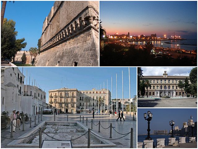
- Italian city, capital of the Apulia region
Hiking in Bari
Hiking in Bari, a beautiful coastal city in southern Italy, offers a range of opportunities to explore both the natural beauty and cultural heritage of the region. While Bari itself is more urban, the surrounding areas provide some excellent hiking experiences. Here are a few key points to consider:...
- Country:
- Postal Code: 70121–70132
- Local Dialing Code: 080
- Licence Plate Code: BA
- Coordinates: 41° 7' 31" N, 16° 52' 0" E
- GPS tracks (wikiloc): [Link]
- AboveSeaLevel: 5 м m
- Area: 117.39 sq km
- Population: 325183
- Web site: [Link]
Cellamare
- comune of Italy
Hiking in Cellamare
Cellamare is a charming village located in the region of Apulia, southern Italy. While it may not be as well-known for hiking as some other destinations, its surrounding areas offer beautiful landscapes and opportunities for outdoor activities....
- Country:
- Postal Code: 70010
- Local Dialing Code: 080
- Licence Plate Code: BA
- Coordinates: 41° 1' 13" N, 16° 55' 45" E
- GPS tracks (wikiloc): [Link]
- AboveSeaLevel: 110 м m
- Area: 5.91 sq km
- Population: 5792
- Web site: [Link]
Casamassima
- Italian comune
Hiking in Casamassima
Casamassima is a charming town in the Apulia region of Italy, located near the metropolitan area of Bari. It is known for its picturesque landscapes, historical sites, and nature trails, making it a great destination for hiking enthusiasts. Here are some highlights about hiking in and around Casamassima:...
- Country:
- Postal Code: 70010
- Local Dialing Code: 080
- Licence Plate Code: BA
- Coordinates: 40° 57' 0" N, 16° 55' 0" E
- GPS tracks (wikiloc): [Link]
- AboveSeaLevel: 223 м m
- Area: 78.43 sq km
- Population: 19777
- Web site: [Link]


Noicattaro
- Italian comune
Hiking in Noicattaro
Noicàttaro is a charming town located in the Apulia region of Italy, known for its agricultural landscapes and a rich cultural heritage. While it may not be as famous for hiking as some other areas in Italy, it offers several opportunities for walking and exploring the natural beauty of the region. Here are some insights about hiking in and around Noicàttaro:...
- Country:
- Postal Code: 70016
- Local Dialing Code: 080-478
- Licence Plate Code: BA
- Coordinates: 41° 2' 0" N, 16° 59' 0" E
- GPS tracks (wikiloc): [Link]
- AboveSeaLevel: 99 м m
- Area: 40.79 sq km
- Population: 26325
- Web site: [Link]
Triggiano
- Italian comune
Hiking in Triggiano
Triggiano is a town in the Metropolitan City of Bari, situated in the Apulia region of Italy. While it is not primarily known for extensive hiking trails, it does offer opportunities for those interested in exploring natural surroundings and nearby areas....
- Country:
- Postal Code: 70019
- Local Dialing Code: 080
- Licence Plate Code: BA
- Coordinates: 41° 4' 0" N, 16° 55' 0" E
- GPS tracks (wikiloc): [Link]
- AboveSeaLevel: 60 м m
- Area: 20.11 sq km
- Population: 27180
- Web site: [Link]

Valenzano
- Italian comune
Hiking in Valenzano
Valenzano, located in the Apulia region of Italy, offers a charming setting for outdoor activities, including hiking. Although a smaller town, it is surrounded by lush landscapes and the natural beauty typical of the Apulian countryside....
- Country:
- Postal Code: 70010
- Local Dialing Code: 080
- Licence Plate Code: BA
- Coordinates: 41° 3' 0" N, 16° 53' 0" E
- GPS tracks (wikiloc): [Link]
- AboveSeaLevel: 85 м m
- Area: 15.98 sq km
- Population: 17952
- Web site: [Link]