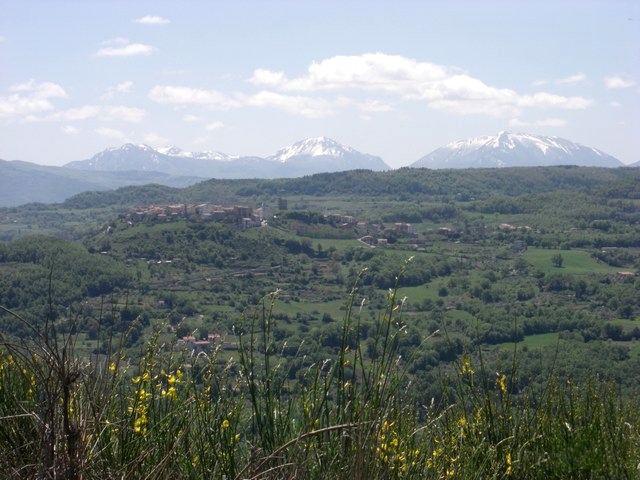
Carbone, Basilicata (Carbone)
.svg)
- Italian comune
 Hiking in Carbone, Basilicata
Hiking in Carbone, a small town in the Basilicata region of southern Italy, offers a unique experience surrounded by stunning landscapes, rich history, and a peaceful atmosphere. Here are some highlights of hiking in this area:
1. :
- Carbone is situated in the mountainous terrain of the Apennines, providing hikers with scenic views of rolling hills, valleys, and forests. The region's diverse flora and fauna create a picturesque backdrop for hiking.
2. :
- As you hike around Carbone, you'll encounter historical landmarks and ancient ruins. The town has a rich history, and exploring its narrow streets can be just as rewarding as hitting the trails.
3. :
- While Carbone itself may not have extensive marked trails, the surrounding areas offer various hiking paths. Nearby natural parks, such as the Pollino National Park and the Val d'Agri, feature well-maintained trails for all levels of hikers.
4. :
- The best time to hike in Carbone is during the spring (April to June) and early fall (September to October) when temperatures are mild, and the trails are less crowded. Summers can be hot, so planning early morning or late afternoon hikes is advisable.
5. :
- The region is abundant in wildlife, including various bird species and small mammals. Hikers may enjoy the chance to observe these animals in their natural habitats while exploring the trails.
6. :
- After a day of hiking, indulging in local cuisine is a must. Carbone offers traditional dishes that reflect the flavors of Basilicata, often featuring fresh ingredients and rustic cooking techniques.
7. :
- For those unfamiliar with the area, consider joining a guided hiking tour. Local guides can provide insight into the terrain, flora, and history of the region, enhancing your outdoor experience.
8. :
- As always, when hiking, be sure to prepare adequately. Bring plenty of water, wear appropriate footwear, and check weather conditions. Inform someone about your hiking plans and estimated return time.
Hiking in Carbone can be a rewarding adventure, offering tranquility and the chance to enjoy Italy’s beautiful natural landscapes away from the more crowded tourist areas.
- Country:

- Postal Code: 85030
- Local Dialing Code: 0973
- Licence Plate Code: PZ
- Coordinates: 40° 8' 0" N, 16° 5' 0" E


- GPS tracks (wikiloc): [Link]
- AboveSeaLevel: 690 м m
- Area: 48.53 sq km
- Population: 608
- Web site: http://www.comune.carbone.pz.it
- Wikipedia en: wiki(en)
- Wikipedia: wiki(it)
- Wikidata storage: Wikidata: Q52549
- Wikipedia Commons Category: [Link]
- Freebase ID: [/m/0fgzmw]
- GeoNames ID: Alt: [6540030]
- VIAF ID: Alt: [236997518]
- OSM relation ID: [40279]
- ISTAT ID: 076019
- Italian cadastre code: B743
Shares border with regions:
Calvera
- Italian comune
Hiking in Calvera
Calavera, often referred to as Calavera Lake or the Calavera Nature Preserve, is a great place for hiking and exploring. Located near the town of Carlsbad in California, this area offers a blend of natural beauty, diverse ecosystems, and historical significance....
- Country:
- Postal Code: 85030
- Local Dialing Code: 0973
- Licence Plate Code: PZ
- Coordinates: 40° 9' 0" N, 16° 9' 0" E
- GPS tracks (wikiloc): [Link]
- AboveSeaLevel: 630 м m
- Area: 16.01 sq km
- Population: 384
- Web site: [Link]
Castelsaraceno
- Italian comune
Hiking in Castelsaraceno
Castelsaraceno is a charming village located in the Basilicata region of southern Italy, nestled within the beautiful landscape of the Apennine Mountains. Hiking in and around Castelsaraceno offers a wonderful combination of natural beauty, historical significance, and diverse trails....
- Country:
- Postal Code: 85031
- Local Dialing Code: 0973
- Licence Plate Code: PZ
- Coordinates: 40° 10' 0" N, 15° 59' 0" E
- GPS tracks (wikiloc): [Link]
- AboveSeaLevel: 960 м m
- Area: 74.78 sq km
- Population: 1349
- Web site: [Link]
Episcopia
- Italian comune
Hiking in Episcopia
Episcopia, a charming town in the Basilicata region of southern Italy, is not as well-known for hiking as some other areas in the country, but it offers some beautiful landscapes and trails that are perfect for outdoor enthusiasts. The region is characterized by its rolling hills, lush greenery, and scenic views of the surrounding countryside....
- Country:
- Postal Code: 85033
- Local Dialing Code: 0973
- Licence Plate Code: PZ
- Coordinates: 40° 4' 29" N, 16° 5' 53" E
- GPS tracks (wikiloc): [Link]
- AboveSeaLevel: 530 м m
- Area: 28.64 sq km
- Population: 1389
- Web site: [Link]
Fardella, Basilicata
- Italian comune
Hiking in Fardella, Basilicata
Fardella is a small village in the Basilicata region of Italy, known for its picturesque landscapes and natural beauty, making it an ideal spot for hiking enthusiasts. Here are some key highlights and tips for hiking in and around Fardella:...
- Country:
- Postal Code: 85030
- Local Dialing Code: 0973
- Licence Plate Code: PZ
- Coordinates: 40° 7' 0" N, 16° 10' 0" E
- GPS tracks (wikiloc): [Link]
- AboveSeaLevel: 745 м m
- Area: 29.08 sq km
- Population: 631
- Web site: [Link]


Latronico
- Italian comune
Hiking in Latronico
Latronico, a picturesque town in the southern Italian region of Basilicata, is an excellent destination for hiking enthusiasts. Nestled in the Pollino National Park, Latronico offers a mix of natural beauty, historical sites, and varying terrain suitable for different levels of hiking experience. Here are some key points to consider for hiking in this area:...
- Country:
- Postal Code: 85043
- Local Dialing Code: 0973
- Licence Plate Code: PZ
- Coordinates: 40° 5' 0" N, 16° 1' 0" E
- GPS tracks (wikiloc): [Link]
- AboveSeaLevel: 888 м m
- Area: 76.66 sq km
- Population: 4420
- Web site: [Link]
San Chirico Raparo
- Italian comune
Hiking in San Chirico Raparo
San Chirico Raparo is a small town located in the Basilicata region of southern Italy. Nestled in the Apennine mountain range, it offers a unique blend of scenic beauty, cultural heritage, and opportunities for hiking enthusiasts. Here’s what you need to know about hiking in and around San Chirico Raparo:...
- Country:
- Postal Code: 85030
- Local Dialing Code: 0973
- Licence Plate Code: PZ
- Coordinates: 40° 11' 0" N, 16° 5' 0" E
- GPS tracks (wikiloc): [Link]
- AboveSeaLevel: 780 м m
- Area: 84.07 sq km
- Population: 1032
- Web site: [Link]

Teana
- Italian comune
Hiking in Teana
Teana, located in the region of Calabria in southern Italy, offers beautiful landscapes and a variety of hiking opportunities. The area is known for its natural beauty, featuring mountains, forests, and picturesque views of the surrounding valleys and the Tyrrhenian Sea. Here are some key points to consider when hiking in Teana:...
- Country:
- Postal Code: 85030
- Local Dialing Code: 0973
- Licence Plate Code: PZ
- Coordinates: 40° 7' 40" N, 16° 9' 19" E
- GPS tracks (wikiloc): [Link]
- AboveSeaLevel: 806 м m
- Area: 19.3 sq km
- Population: 585
- Web site: [Link]