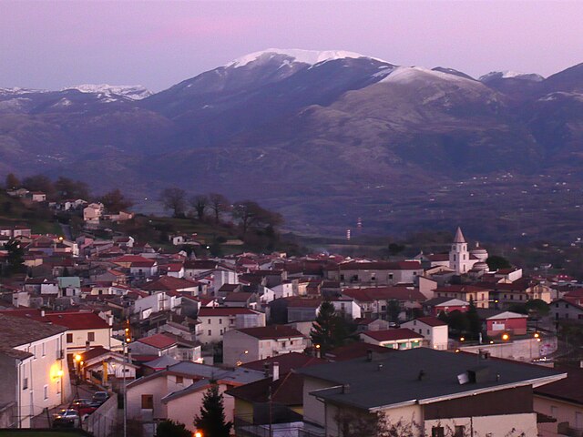
Latronico (Latronico)
.svg)
- Italian comune
 Hiking in Latronico
Latronico, a picturesque town in the southern Italian region of Basilicata, is an excellent destination for hiking enthusiasts. Nestled in the Pollino National Park, Latronico offers a mix of natural beauty, historical sites, and varying terrain suitable for different levels of hiking experience. Here are some key points to consider for hiking in this area:
Trails and Routes
- Monte Serra: This mountain offers trails with stunning panoramic views. The hike is moderately challenging, making it suitable for experienced hikers.
- Aqueduct Trail: A relatively easier trek that follows an ancient aqueduct, providing scenic views of the surrounding countryside.
- Pollino National Park: The park is home to numerous hiking trails of varying difficulties. You can explore the breathtaking landscapes, unique flora and fauna, and even historical sites like ancient hermitages.
Flora and Fauna
The region is rich in biodiversity. Hikers can expect to see various species of trees, such as beech, fir, and pines, along with wildflowers in the spring. Wildlife includes deer, foxes, and a variety of birds, making it a great spot for nature lovers and birdwatchers.
Best Time to Hike
The best times for hiking in Latronico are spring (April to June) and fall (September to October) when the weather is mild, and the landscapes are particularly beautiful. Summers can be hot, while winters may bring snow to the higher elevations.
Preparation and Safety
- Gear: Ensure you have appropriate hiking shoes, a good backpack, and plenty of water. Consider trekking poles for added stability.
- Maps and Guides: While many trails are marked, it's wise to carry a map or download a hiking app that includes the routes. Local guides can also be a great resource.
- Weather: Always check the weather forecast before heading out, as conditions can change quickly in mountainous regions.
Local Culture
Don’t miss the chance to explore Latronico’s quaint streets, local cuisine, and traditional festivals, enhancing your hiking experience with cultural immersion.
Conclusion
Hiking in Latronico offers a blend of adventure and tranquility, with stunning natural beauty and opportunities for exploration. Whether you're a novice or an experienced hiker, the trails around Latronico promise a rewarding experience. Make sure to respect the environment and leave no trace while enjoying this beautiful part of Italy.
- Country:

- Postal Code: 85043
- Local Dialing Code: 0973
- Licence Plate Code: PZ
- Coordinates: 40° 5' 0" N, 16° 1' 0" E


- GPS tracks (wikiloc): [Link]
- AboveSeaLevel: 888 м m
- Area: 76.66 sq km
- Population: 4420
- Web site: http://www.comune.latronico.pz.it/
- Wikipedia en: wiki(en)
- Wikipedia: wiki(it)
- Wikidata storage: Wikidata: Q52587
- Wikipedia Commons Category: [Link]
- Freebase ID: [/m/0fh3gk]
- GeoNames ID: Alt: [6539000]
- VIAF ID: Alt: [135753193]
- OSM relation ID: [40229]
- MusicBrainz area ID: [444043ee-6356-4ddf-9b09-e7d7c3f4ec17]
- WOEID: [717059]
- UN/LOCODE: [ITLAI]
- Digital Atlas of the Roman Empire ID: [30447]
- ISTAT ID: 076040
- Italian cadastre code: E474
Shares border with regions:
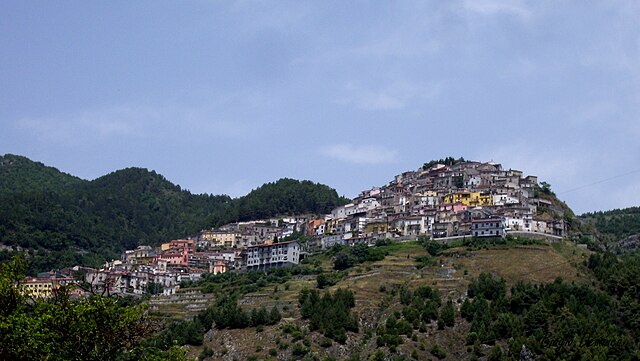
Carbone, Basilicata
- Italian comune
Hiking in Carbone, Basilicata
Hiking in Carbone, a small town in the Basilicata region of southern Italy, offers a unique experience surrounded by stunning landscapes, rich history, and a peaceful atmosphere. Here are some highlights of hiking in this area:...
- Country:
- Postal Code: 85030
- Local Dialing Code: 0973
- Licence Plate Code: PZ
- Coordinates: 40° 8' 0" N, 16° 5' 0" E
- GPS tracks (wikiloc): [Link]
- AboveSeaLevel: 690 м m
- Area: 48.53 sq km
- Population: 608
- Web site: [Link]

Castelluccio Inferiore
- Italian comune
Hiking in Castelluccio Inferiore
Castelluccio Inferiore is a charming village located in the Basilicata region of southern Italy, known for its picturesque landscapes and proximity to the Pollino National Park, which offers a wealth of hiking opportunities. Hikes in and around this area allow you to appreciate the stunning natural beauty, rich biodiversity, and unique geological features....
- Country:
- Postal Code: 85040
- Local Dialing Code: 0973
- Licence Plate Code: PZ
- Coordinates: 40° 0' 0" N, 15° 59' 0" E
- GPS tracks (wikiloc): [Link]
- AboveSeaLevel: 495 м m
- Area: 28.96 sq km
- Population: 2072
- Web site: [Link]

Castelluccio Superiore
- Italian comune
Hiking in Castelluccio Superiore
Castelluccio Superiore, located in the Basilicata region of southern Italy, is a charming destination for hikers and nature enthusiasts. This picturesque village offers stunning landscapes, rich biodiversity, and a network of trails that showcase the beauty of the surrounding Apennine Mountains....
- Country:
- Postal Code: 85040
- Local Dialing Code: 0973
- Licence Plate Code: PZ
- Coordinates: 40° 1' 0" N, 15° 59' 0" E
- GPS tracks (wikiloc): [Link]
- AboveSeaLevel: 680 м m
- Area: 32.98 sq km
- Population: 796
- Web site: [Link]
Castelsaraceno
- Italian comune
Hiking in Castelsaraceno
Castelsaraceno is a charming village located in the Basilicata region of southern Italy, nestled within the beautiful landscape of the Apennine Mountains. Hiking in and around Castelsaraceno offers a wonderful combination of natural beauty, historical significance, and diverse trails....
- Country:
- Postal Code: 85031
- Local Dialing Code: 0973
- Licence Plate Code: PZ
- Coordinates: 40° 10' 0" N, 15° 59' 0" E
- GPS tracks (wikiloc): [Link]
- AboveSeaLevel: 960 м m
- Area: 74.78 sq km
- Population: 1349
- Web site: [Link]
Episcopia
- Italian comune
Hiking in Episcopia
Episcopia, a charming town in the Basilicata region of southern Italy, is not as well-known for hiking as some other areas in the country, but it offers some beautiful landscapes and trails that are perfect for outdoor enthusiasts. The region is characterized by its rolling hills, lush greenery, and scenic views of the surrounding countryside....
- Country:
- Postal Code: 85033
- Local Dialing Code: 0973
- Licence Plate Code: PZ
- Coordinates: 40° 4' 29" N, 16° 5' 53" E
- GPS tracks (wikiloc): [Link]
- AboveSeaLevel: 530 м m
- Area: 28.64 sq km
- Population: 1389
- Web site: [Link]
Fardella, Basilicata
- Italian comune
Hiking in Fardella, Basilicata
Fardella is a small village in the Basilicata region of Italy, known for its picturesque landscapes and natural beauty, making it an ideal spot for hiking enthusiasts. Here are some key highlights and tips for hiking in and around Fardella:...
- Country:
- Postal Code: 85030
- Local Dialing Code: 0973
- Licence Plate Code: PZ
- Coordinates: 40° 7' 0" N, 16° 10' 0" E
- GPS tracks (wikiloc): [Link]
- AboveSeaLevel: 745 м m
- Area: 29.08 sq km
- Population: 631
- Web site: [Link]


Lauria
- Italian comune
Hiking in Lauria
Lauria is a beautiful location in the Basilicata region of southern Italy, known for its stunning landscapes, rich history, and outdoor activities, including hiking. The area offers a variety of trails suitable for different skill levels, from easy walks to more challenging hikes, all set against the backdrop of the Apennine mountains....
- Country:
- Postal Code: 85044
- Local Dialing Code: 0973
- Licence Plate Code: PZ
- Coordinates: 40° 2' 50" N, 15° 50' 9" E
- GPS tracks (wikiloc): [Link]
- AboveSeaLevel: 430 м m
- Area: 176.63 sq km
- Population: 12694
- Web site: [Link]