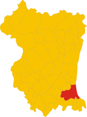
Casarsa della Delizia (Casarsa della Delizia)
- Italian comune
 Hiking in Casarsa della Delizia
Casarsa della Delizia, located in the Friuli Venezia Giulia region of northeastern Italy, is known for its beautiful landscapes and proximity to the striking natural features of the area. While this small town itself may not have extensive hiking trails directly within its limits, it serves as a great base for exploring the surrounding countryside and nearby natural parks.
Hiking Opportunities Nearby:
-
Tagliamento River Valley: Just a short drive from Casarsa, the Tagliamento River offers scenic trails along its banks where you can enjoy views of the water, local flora, and fauna.
-
Colli Orientali del Friuli: This wine-producing area features a number of hiking trails that wind through vineyards, rolling hills, and charming villages. The trails offer stunning vistas of the Friulian landscape.
-
Parco Naturale delle Prealpi Giulie: A bit further away, the Prealpi Giulie Park provides more challenging hiking options with well-marked trails leading through rugged mountains and lush forests.
-
Lago di Cavazzo: A great spot for a day hike, this lake is surrounded by trails that offer views of the water and access to nearby woodlands. It is perfect for those looking for scenic beauty and a relaxed walking pace.
Hiking Tips:
-
Seasonal Considerations: The best times to hike in this region are spring and fall when the weather is mild and the scenery is vibrant with colors. Summer can be hot, while winter may bring snow to higher elevations.
-
Footwear and Gear: Wear sturdy hiking boots and bring plenty of water, especially during warmer months. It's also wise to carry a map or use a GPS app to keep track of trail routes.
-
Local Regulations: Respect the local environment and follow park regulations, especially in natural reserves or protected areas.
-
Cultural Stops: Don't miss the chance to explore local vineyards, taste traditional Friulian cuisine, or visit historical sites in Casarsa and its surroundings while hiking.
While Casarsa della Delizia is more subdued compared to prominent hiking destinations, its proximity to beautiful landscapes makes it a great spot for hikers looking to explore the Friuli Venezia Giulia region.
- Country:

- Postal Code: 33072
- Local Dialing Code: 0434
- Licence Plate Code: PN
- Coordinates: 45° 57' 0" N, 12° 51' 0" E


- GPS tracks (wikiloc): [Link]
- AboveSeaLevel: 44 м m
- Area: 20.47 sq km
- Population: 8404
- Web site: http://www.comune.casarsadelladelizia.pn.it/
- Wikipedia en: wiki(en)
- Wikipedia: wiki(it)
- Wikidata storage: Wikidata: Q53157
- Wikipedia Commons Category: [Link]
- Freebase ID: [/m/0gqz2_]
- GeoNames ID: Alt: [6539325]
- VIAF ID: Alt: [234312709]
- OSM relation ID: [79279]
- archINFORM location ID: [888]
- MusicBrainz area ID: [c41f494b-3c36-4737-8453-36e4b8c0e7c7]
- UN/LOCODE: [ITCRF]
- ISTAT ID: 093010
- Italian cadastre code: B940
Shares border with regions:
Fiume Veneto
- Italian comune
Fiume Veneto is a charming town located in the Friuli Venezia Giulia region of northeastern Italy. While it may not be as well-known as some of the larger national parks or hiking areas in Italy, it has its own unique appeal for those looking to explore the beautiful landscapes of the region. Here are some key aspects of hiking in and around Fiume Veneto:...
- Country:

- Postal Code: 33080
- Local Dialing Code: 0434
- Licence Plate Code: PN
- Coordinates: 45° 56' 0" N, 12° 44' 0" E


- GPS tracks (wikiloc): [Link]
- AboveSeaLevel: 20 м m
- Area: 35.76 sq km
- Population: 11729
- Web site: [Link]


San Vito al Tagliamento
- Italian comune
 Hiking in San Vito al Tagliamento
San Vito al Tagliamento, located in the Friuli Venezia Giulia region of northeastern Italy, is a charming town surrounded by picturesque landscapes, making it a great spot for hiking enthusiasts. The area features a mixture of rolling hills, woodlands, and agricultural fields, providing a variety of trails for different skill levels....
- Country:

- Postal Code: 33078
- Local Dialing Code: 0434
- Licence Plate Code: PN
- Coordinates: 45° 54' 55" N, 12° 51' 20" E


- GPS tracks (wikiloc): [Link]
- AboveSeaLevel: 30 м m
- Area: 60.88 sq km
- Population: 15063
- Web site: [Link]


Zoppola
- Italian comune
Zoppola is a charming municipality in the Friuli Venezia Giulia region of northern Italy. While it may not be as widely known for hiking as some other areas, it is surrounded by beautiful landscapes that can offer some enjoyable outdoor experiences. Here are some aspects of hiking in and around Zoppola:...
- Country:

- Postal Code: 33080
- Local Dialing Code: 0434
- Licence Plate Code: PN
- Coordinates: 45° 58' 0" N, 12° 46' 0" E


- GPS tracks (wikiloc): [Link]
- AboveSeaLevel: 36 м m
- Area: 45.54 sq km
- Population: 8483
- Web site: [Link]
