Cassano Valcuvia (Cassano Valcuvia)
- Italian comune
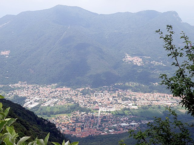
Cassano Valcuvia is a charming town located in the province of Varese in the Lombardy region of Italy. Nestled in the foothills of the Alps, it offers a variety of hiking opportunities that are perfect for outdoor enthusiasts of all skill levels. Here’s what you can expect when hiking in Cassano Valcuvia:
Scenic Trails
-
Nature Trails: The area is known for its lush landscapes, including forests, hills, and beautiful views of the surrounding valleys. Many trails are well-marked and provide a peaceful escape into nature.
-
Varied Difficulty Levels: Whether you’re a beginner or an experienced hiker, you’ll find trails to match your level. Some routes are easy and suitable for families, while others may lead you to higher elevations with more challenging terrain.
Points of Interest
-
Monte Campo dei Fiori: This mountain, part of the Campo dei Fiori Regional Park, is popular among hikers and offers stunning panoramic views from the summit. The routes here can be a bit strenuous but reward you with breathtaking sights.
-
Cultural Landmarks: Along some hiking routes, you may also encounter historic sites, small chapels, and scenic viewpoints that enrich the experience.
Flora and Fauna
The biodiversity in this region is impressive, with various species of trees, plants, and wildlife. Birdwatchers and nature lovers will enjoy spotting different species along the trails.
Best Time to Hike
The best seasons for hiking in Cassano Valcuvia are spring (April to June) and autumn (September to October) when the weather is mild, and the landscapes are particularly beautiful. Summer can be warm, but it’s also a time for vibrant greenery.
Practical Tips
-
Gear: Wear proper hiking shoes and consider bringing trekking poles if you're tackling more challenging trails. A good backpack with water and snacks is also advisable.
-
Maps and Apps: Make sure you have a reliable map or use a hiking app to stay oriented, as some trails may not be well-marked.
-
Local Guidance: If you're unfamiliar with the area, think about joining a guided group hike. Local guides can provide insights into the region's natural history and help ensure safety.
-
Respect the Environment: Practice Leave No Trace principles to help preserve the natural beauty of Cassano Valcuvia for future visitors.
Hiking in Cassano Valcuvia is a rewarding way to experience Italy’s stunning landscapes and enjoy the tranquility of nature. Whether you’re out for a short day hike or a longer trek, you’re sure to find plenty of opportunities for adventure and exploration!
- Country:

- Postal Code: 21030
- Local Dialing Code: 0332
- Licence Plate Code: VA
- Coordinates: 45° 56' 0" N, 8° 46' 0" E


- GPS tracks (wikiloc): [Link]
- AboveSeaLevel: 296 м m
- Area: 3.95 sq km
- Population: 675
- Web site: http://www.comune.cassanovalcuvia.va.it
- Wikipedia en: wiki(en)
- Wikipedia: wiki(it)
- Wikidata storage: Wikidata: Q40917
- Wikipedia Commons Category: [Link]
- Freebase ID: [/m/0ghybl]
- GeoNames ID: Alt: [6543719]
- VIAF ID: Alt: [237042159]
- OSM relation ID: [46522]
- UN/LOCODE: [ITCCU]
- ISTAT ID: 012041
- Italian cadastre code: B999
Shares border with regions:


Cuveglio
- Italian comune
Cuveglio is a charming town located in the Lombardy region of Italy, near the larger city of Varese and the scenic Lake Maggiore. The area surrounding Cuveglio boasts beautiful landscapes, including hills, forests, and pathways perfect for hiking enthusiasts. Here are some key points about hiking in Cuveglio:...
- Country:

- Postal Code: 21030
- Local Dialing Code: 0332
- Licence Plate Code: VA
- Coordinates: 45° 54' 21" N, 8° 44' 3" E


- GPS tracks (wikiloc): [Link]
- AboveSeaLevel: 294 м m
- Area: 7.53 sq km
- Population: 3375
- Web site: [Link]
Grantola
- Italian comune
Grantola is a picturesque area located in the province of Varese, Lombardy, Italy, nestled in the foothills of the Alps and near the shores of Lake Lugano. It's a beautiful destination for hiking enthusiasts, offering various trails that showcase the stunning natural landscape....
- Country:

- Postal Code: 21030
- Local Dialing Code: 0332
- Licence Plate Code: VA
- Coordinates: 45° 57' 0" N, 8° 47' 0" E


- GPS tracks (wikiloc): [Link]
- AboveSeaLevel: 250 м m
- Area: 2.05 sq km
- Population: 1288
- Web site: [Link]
Mesenzana
- Italian comune
Mesenzana is a charming municipality located in the province of Varese, Lombardy, Italy. Nestled in the foothills of the Alps and near the shores of Lake Maggiore, it offers stunning natural scenery and various hiking opportunities....
- Country:

- Postal Code: 21030
- Local Dialing Code: 0332
- Licence Plate Code: VA
- Coordinates: 45° 56' 49" N, 8° 45' 32" E


- GPS tracks (wikiloc): [Link]
- AboveSeaLevel: 305 м m
- Area: 4.88 sq km
- Population: 1534
- Web site: [Link]


Ferrera di Varese
- Italian comune
Ferrera di Varese is a charming municipality located in the province of Varese in the Lombardy region of northern Italy. The area is particularly known for its beautiful natural landscapes, making it a great destination for hiking enthusiasts....
- Country:

- Postal Code: 21030
- Local Dialing Code: 0332
- Licence Plate Code: VA
- Coordinates: 45° 56' 0" N, 8° 47' 0" E


- GPS tracks (wikiloc): [Link]
- AboveSeaLevel: 299 м m
- Area: 1.53 sq km
- Population: 703
- Web site: [Link]


Rancio Valcuvia
- Italian comune
Rancio Valcuvia is a charming area located in the province of Varese in Lombardy, Italy, surrounded by stunning natural landscapes. The region is characterized by its hills, valleys, and the nearby presence of the Prealps, making it an excellent destination for hiking enthusiasts....
- Country:

- Postal Code: 21030
- Local Dialing Code: 0332
- Licence Plate Code: VA
- Coordinates: 45° 54' 0" N, 8° 46' 0" E


- GPS tracks (wikiloc): [Link]
- AboveSeaLevel: 296 м m
- Area: 4.45 sq km
- Population: 937
- Web site: [Link]
Duno
- Italian comune
Duno is a beautiful area located in the Lombardy region of northern Italy, known for its scenic landscapes, lush greenery, and serene lakes. It offers several hiking options suitable for various skill levels. Here’s what you need to know about hiking in Duno:...
- Country:

- Postal Code: 21030
- Local Dialing Code: 0332
- Licence Plate Code: VA
- Coordinates: 45° 55' 0" N, 8° 44' 0" E


- GPS tracks (wikiloc): [Link]
- AboveSeaLevel: 530 м m
- Area: 2.49 sq km
- Population: 125
- Web site: [Link]

