
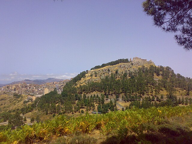
Castelbuono (Castelbuono)
.svg)
- Italian comune
 Hiking in Castelbuono
Castelbuono, located in the Madonie Mountains of Sicily, Italy, is a fantastic area for hiking enthusiasts. Known for its rich history, charming medieval architecture, and stunning natural landscapes, Castelbuono offers a variety of trails suitable for different skill levels.
Key Features of Hiking in Castelbuono:
-
Natural Beauty: The Madonie Park surrounding Castelbuono is renowned for its diverse flora and fauna. Hikers can enjoy lush forests, rocky terrains, and panoramic views of both the mountains and the surrounding coastline.
-
Trail Variety: There are numerous trails around Castelbuono, ranging from easy walks to more challenging hikes. Some popular routes include:
- Monte dei Cervi: A moderate hike that offers stunning views from its summit.
- The Trail to Piano Zucchi: A scenic route that leads through beautiful woods and meadows.
-
Historical Landmarks: Many hiking routes pass by significant historical sites, such as the Castello dei Ventimiglia, which adds an educational aspect to the outdoor experience.
-
Flora and Fauna: The area is home to various plant species and wildlife, making it a great spot for nature lovers and bird watchers.
-
Local Cuisine: After a day of hiking, you can enjoy traditional Sicilian cuisine in Castelbuono’s quaint restaurants, savoring local specialties like "pane di Castelbuono," a unique bread.
-
Accessibility: The town is relatively easy to access by car, and there are parking facilities available. Additionally, many trails are well-marked, making it easier for hikers to navigate.
Tips for Hiking in Castelbuono:
- Wear Proper Footwear: Good hiking boots are essential, especially on rocky and uneven terrain.
- Check the Weather: Conditions can change quickly in the mountains, so it’s best to be prepared for various weather scenarios.
- Stay Hydrated: Carry enough water, particularly on longer hikes, as some trails may not have reliable water sources.
- Respect Nature: Follow leave-no-trace principles to help preserve the natural beauty of the area.
Overall, hiking in Castelbuono is a rewarding experience, combining physical activity with stunning views and cultural exploration. Enjoy your adventure!
- Country:

- Postal Code: 90013
- Local Dialing Code: 0921
- Licence Plate Code: PA
- Coordinates: 37° 55' 31" N, 14° 5' 12" E


- GPS tracks (wikiloc): [Link]
- AboveSeaLevel: 423 м m
- Area: 60.79 sq km
- Population: 8688
- Web site: http://www.comune.castelbuono.pa.it
- Wikipedia en: wiki(en)
- Wikipedia: wiki(it)
- Wikidata storage: Wikidata: Q491420
- Wikipedia Commons Gallery: [Link]
- Wikipedia Commons Category: [Link]
- Freebase ID: [/m/0bvp9f]
- GeoNames ID: Alt: [6540049]
- BnF ID: [119733465]
- VIAF ID: Alt: [142086912]
- OSM relation ID: [39417]
- GND ID: Alt: [4216286-5]
- Library of Congress authority ID: Alt: [n2001156466]
- UN/LOCODE: [ITCP8]
- ISTAT ID: 082022
- Italian cadastre code: C067
Shares border with regions:


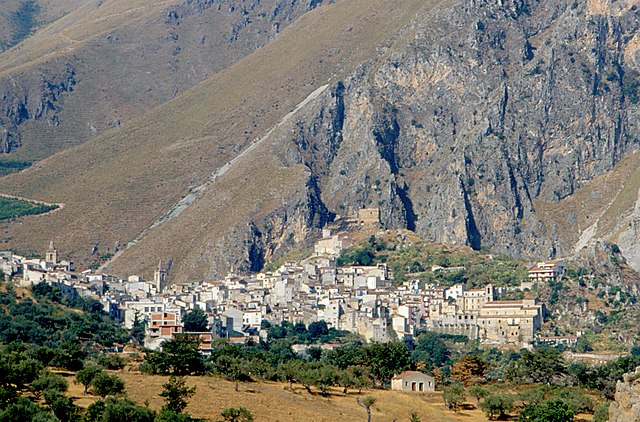
Cefalù
- Italian comune
Hiking in Cefalù
Cefalù, located on the northern coast of Sicily, Italy, is renowned not only for its beautiful beaches and historic architecture but also for its stunning hiking opportunities. Here are some highlights and tips for hiking in and around Cefalù:...
- Country:
- Postal Code: 90015
- Local Dialing Code: 0921
- Licence Plate Code: PA
- Coordinates: 38° 2' 22" N, 14° 1' 19" E
- GPS tracks (wikiloc): [Link]
- AboveSeaLevel: 16 м m
- Area: 66.24 sq km
- Population: 14298
- Web site: [Link]

Geraci Siculo
- Italian comune
Hiking in Geraci Siculo
Geraci Siculo is a charming village located in the Madonie Mountains in Sicily, Italy. It offers a unique combination of natural beauty, rich cultural heritage, and a variety of hiking opportunities. Here’s what you can expect when hiking in and around Geraci Siculo:...
- Country:
- Postal Code: 90010
- Local Dialing Code: 0921
- Licence Plate Code: PA
- Coordinates: 37° 52' 0" N, 14° 9' 0" E
- GPS tracks (wikiloc): [Link]
- AboveSeaLevel: 1072 м m
- Area: 113.35 sq km
- Population: 1820
- Web site: [Link]


San Mauro Castelverde
- Italian comune
Hiking in San Mauro Castelverde
San Mauro Castelverde, located in the province of Palermo on the island of Sicily, Italy, offers a range of beautiful hiking opportunities for outdoor enthusiasts. Situated in the Madonie National Park, this area is rich in natural beauty, biodiversity, and stunning landscapes....
- Country:
- Postal Code: 90010
- Local Dialing Code: 0921
- Licence Plate Code: PA
- Coordinates: 37° 54' 52" N, 14° 11' 26" E
- GPS tracks (wikiloc): [Link]
- AboveSeaLevel: 1050 м m
- Area: 114.37 sq km
- Population: 1590
- Web site: [Link]


Petralia Sottana
- Italian comune
Hiking in Petralia Sottana
Petralia Sottana is a charming town situated in the Madonie Mountains of Sicily, Italy. It offers a variety of hiking opportunities for outdoor enthusiasts, making it a great destination for those looking to explore nature. Here are some key points and recommendations for hiking in the area:...
- Country:
- Postal Code: 90027
- Local Dialing Code: 0921
- Licence Plate Code: PA
- Coordinates: 37° 48' 0" N, 14° 5' 0" E
- GPS tracks (wikiloc): [Link]
- AboveSeaLevel: 1000 м m
- Area: 178.35 sq km
- Population: 2730
- Web site: [Link]

Isnello
- Italian comune
Hiking in Isnello
Isnello is a picturesque village located in the Madonie Mountains of Sicily, Italy. This area offers beautiful landscapes, unique geological formations, and a rich variety of flora and fauna, making it an excellent destination for hiking enthusiasts. Here are some key points about hiking in Isnello:...
- Country:
- Postal Code: 90010
- Local Dialing Code: 0921
- Licence Plate Code: PA
- Coordinates: 37° 57' 0" N, 14° 5' 0" E
- GPS tracks (wikiloc): [Link]
- AboveSeaLevel: 530 м m
- Area: 51 sq km
- Population: 1545
- Web site: [Link]


Pollina
- Italian comune
Hiking in Pollina
Pollina, located in Sicily, Italy, is a beautiful destination for hikers and nature enthusiasts. Nestled in the Madonie Regional Park, Pollina offers a variety of hiking trails that cater to different skill levels, making it an ideal spot for both novice and experienced hikers....
- Country:
- Postal Code: 90010
- Local Dialing Code: 0921
- Licence Plate Code: PA
- Coordinates: 37° 59' 35" N, 14° 8' 45" E
- GPS tracks (wikiloc): [Link]
- AboveSeaLevel: 730 м m
- Area: 49.93 sq km
- Population: 2950
- Web site: [Link]