San Mauro Castelverde (San Mauro Castelverde)
.svg)
- Italian comune
 Hiking in San Mauro Castelverde
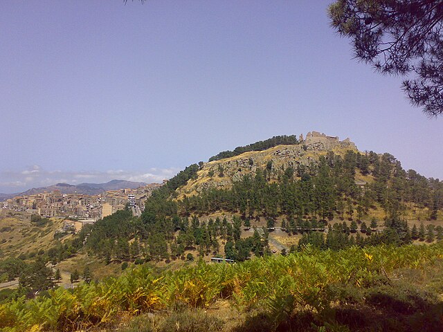
San Mauro Castelverde, located in the province of Palermo on the island of Sicily, Italy, offers a range of beautiful hiking opportunities for outdoor enthusiasts. Situated in the Madonie National Park, this area is rich in natural beauty, biodiversity, and stunning landscapes.
Hiking Trails
-
Sentiero delle Creste: This trail offers breathtaking panoramic views of the Madonie mountains and the surrounding countryside. It's a moderate hike that allows you to experience the diverse flora and fauna of the region.
-
Paths to the Madonie Peaks: More challenging trails lead to the higher peaks of the Madonie range. Hikers can encounter varying terrains, including rocky paths and lush forested areas.
-
La Vallata d'Inferno: This scenic route takes you through a valley with striking rock formations and ancient woodlands. It's a great place for spotting local wildlife.
Natural Features
-
Flora and Fauna: The area is home to an array of plant species, many of which are endemic to Sicily. Birdwatchers will also enjoy the chance to see various bird species, including eagles and hawks.
-
Scenic Views: Hikers can expect stunning views of the surrounding valleys, mountains, and sometimes, if the weather allows, of the Mediterranean coast.
Tips for Hiking
-
Season: Spring and autumn are the best times for hiking in San Mauro Castelverde, as temperatures are milder and the landscapes are lush. Summer can be hot, while winter may have snow in the higher elevations.
-
Gear: Ensure you have proper hiking gear, including sturdy boots, plenty of water, and sun protection.
-
Navigation: While many trails are marked, carrying a map or GPS device is advisable, especially for longer hikes.
-
Local Guide: Consider hiring a local guide for a more enriching experience. They can provide insights into the local ecology, history, and hidden gems of the area.
Cultural Aspects
San Mauro Castelverde itself is a charming village rich in history, with traditional Sicilian architecture, local cuisine, and opportunities to engage with the community. Combining hiking with cultural exploration can make for a well-rounded experience.
In conclusion, hiking in San Mauro Castelverde offers a unique blend of natural beauty, diverse trails, and cultural richness. Whether you are an experienced hiker or a beginner, there's something for everyone in this beautiful part of Sicily.
- Country:

- Postal Code: 90010
- Local Dialing Code: 0921
- Licence Plate Code: PA
- Coordinates: 37° 54' 52" N, 14° 11' 26" E


- GPS tracks (wikiloc): [Link]
- AboveSeaLevel: 1050 м m
- Area: 114.37 sq km
- Population: 1590
- Web site: http://www.comune.sanmaurocastelverde.pa.it
- Wikipedia en: wiki(en)
- Wikipedia: wiki(it)
- Wikidata storage: Wikidata: Q490782
- Wikipedia Commons Category: [Link]
- Freebase ID: [/m/0f8jkr]
- GeoNames ID: Alt: [6539139]
- VIAF ID: Alt: [293789863]
- OSM relation ID: [39418]
- GND ID: Alt: [1030112118]
- Library of Congress authority ID: Alt: [no2012153425]
- UN/LOCODE: [IT2SA]
- ISTAT ID: 082065
- Italian cadastre code: I028
Shares border with regions:

Geraci Siculo
- Italian comune
Hiking in Geraci Siculo
Geraci Siculo is a charming village located in the Madonie Mountains in Sicily, Italy. It offers a unique combination of natural beauty, rich cultural heritage, and a variety of hiking opportunities. Here’s what you can expect when hiking in and around Geraci Siculo:...
- Country:
- Postal Code: 90010
- Local Dialing Code: 0921
- Licence Plate Code: PA
- Coordinates: 37° 52' 0" N, 14° 9' 0" E
- GPS tracks (wikiloc): [Link]
- AboveSeaLevel: 1072 м m
- Area: 113.35 sq km
- Population: 1820
- Web site: [Link]


Castelbuono
- Italian comune
Hiking in Castelbuono
Castelbuono, located in the Madonie Mountains of Sicily, Italy, is a fantastic area for hiking enthusiasts. Known for its rich history, charming medieval architecture, and stunning natural landscapes, Castelbuono offers a variety of trails suitable for different skill levels....
- Country:
- Postal Code: 90013
- Local Dialing Code: 0921
- Licence Plate Code: PA
- Coordinates: 37° 55' 31" N, 14° 5' 12" E
- GPS tracks (wikiloc): [Link]
- AboveSeaLevel: 423 м m
- Area: 60.79 sq km
- Population: 8688
- Web site: [Link]


Tusa
- Italian comune
Hiking in Tusa
Tusa, a charming town located along the northern coast of Sicily, offers a variety of hiking opportunities that showcase the region's stunning natural landscapes, rich history, and diverse ecosystems. Here are some highlights for hiking in the Tusa area:...
- Country:
- Postal Code: 98079
- Local Dialing Code: 0921
- Licence Plate Code: ME
- Coordinates: 37° 59' 0" N, 14° 14' 0" E
- GPS tracks (wikiloc): [Link]
- AboveSeaLevel: 614 м m
- Area: 41.07 sq km
- Population: 2823
- Web site: [Link]
Castel di Lucio
- Italian comune
Hiking in Castel di Lucio
Castel di Lucio is a charming village located in the Nebrodi Mountains of Sicily, Italy. It offers a picturesque setting for hiking enthusiasts, with its stunning landscapes, rich history, and diverse flora and fauna. Here are some notable aspects of hiking in and around Castel di Lucio:...
- Country:
- Postal Code: 98070
- Local Dialing Code: 0921
- Licence Plate Code: ME
- Coordinates: 37° 53' 0" N, 14° 19' 0" E
- GPS tracks (wikiloc): [Link]
- AboveSeaLevel: 753 м m
- Area: 28.78 sq km
- Population: 1277
- Web site: [Link]


Pollina
- Italian comune
Hiking in Pollina
Pollina, located in Sicily, Italy, is a beautiful destination for hikers and nature enthusiasts. Nestled in the Madonie Regional Park, Pollina offers a variety of hiking trails that cater to different skill levels, making it an ideal spot for both novice and experienced hikers....
- Country:
- Postal Code: 90010
- Local Dialing Code: 0921
- Licence Plate Code: PA
- Coordinates: 37° 59' 35" N, 14° 8' 45" E
- GPS tracks (wikiloc): [Link]
- AboveSeaLevel: 730 м m
- Area: 49.93 sq km
- Population: 2950
- Web site: [Link]


Pettineo
- Italian comune
Hiking in Pettineo
Pettineo is a charming village located in the Nebrodi Mountains of Sicily, Italy. It offers a unique blend of natural beauty, cultural heritage, and hiking opportunities. If you're considering hiking in Pettineo, here are some key points to consider:...
- Country:
- Postal Code: 98070
- Local Dialing Code: 0921
- Licence Plate Code: ME
- Coordinates: 37° 58' 0" N, 14° 17' 0" E
- GPS tracks (wikiloc): [Link]
- AboveSeaLevel: 250 м m
- Area: 30.62 sq km
- Population: 1312
- Web site: [Link]