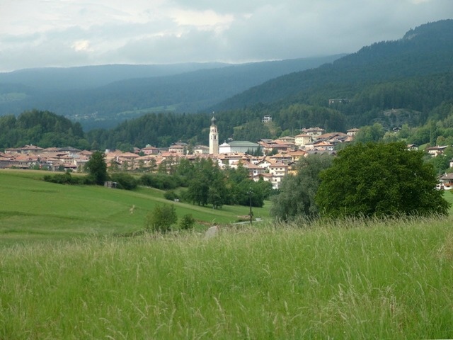
Castelfondo (Castelfondo)
%202018.svg)
- Italian comune
 Hiking in Castelfondo
Castelfondo, located in the Trentino region of northern Italy, is a charming village nestled in the heart of the Val di Non. It's an excellent destination for hikers, offering a blend of stunning natural landscapes and cultural experiences.
Hiking Trails and Areas
-
The Surrounding Nature: The area around Castelfondo is characterized by lush forests, rolling hills, and panoramic views of the surrounding mountains, making it ideal for both leisurely hikes and more challenging treks.
-
Shooting Waterfalls: One popular route from Castelfondo is towards the nearby waterfalls, where you can enjoy the sound of cascading water and the refreshing atmosphere.
-
Mendel Pass: A short ride away, Mendel Pass offers a variety of trails, ranging from easy walks to more difficult hikes, with breathtaking views of the Dolomites.
-
Lake Tret: A bit further, you can hike to Lake Tret, a beautiful alpine lake where you can relax and possibly even take a swim during the summer months.
-
Historical Trails: Some trails also traverse ancient paths, offering glimpses into the region's history and traditional villages.
Difficulty Levels
- Easy Trails: Many trails around Castelfondo are suitable for beginners or families, providing gentle slopes and marked paths.
- Moderate Trails: There are also several moderate hikes that require a good level of fitness and some experience with hiking.
- Challenging Trails: For seasoned hikers, there are more demanding routes that may involve steeper ascents and rugged terrain.
Best Time to Hike
- Spring and Autumn: These seasons offer pleasant weather and stunning natural colors, making them ideal for hiking.
- Summer: While the warmer temperatures are great for hiking, it's advisable to start early in the morning to avoid the midday heat.
- Winter: If you enjoy snowshoeing, the winter months can also provide great opportunities for winter hiking.
Safety Tips
- Prepare: Always check the weather forecast and trail conditions before heading out.
- Gear Up: Wear appropriate hiking boots, carry enough water, and consider bringing snacks.
- Maps and Guides: Familiarize yourself with the trails, and consider getting a local guide if you're venturing into more unfamiliar terrain.
Local Culture
In addition to hiking, Castelfondo has a quaint village atmosphere, with opportunities to explore local cuisine and cultural sites, such as historical churches and traditional farms. The area is also famous for its apple orchards, so don’t miss trying the local apple products.
Overall, hiking in and around Castelfondo provides a perfect mix of outdoor adventure and cultural exploration, suitable for all levels.
- Country:

- Postal Code: 38020
- Local Dialing Code: 0463
- Licence Plate Code: TN
- Coordinates: 46° 27' 0" N, 11° 7' 0" E


- GPS tracks (wikiloc): [Link]
- AboveSeaLevel: 948 м m
- Area: 25.87 sq km
- Population: 614
- Web site: http://www.comune.castelfondo.tn.it
- Wikipedia en: wiki(en)
- Wikipedia: wiki(it)
- Wikidata storage: Wikidata: Q264813
- Wikipedia Commons Category: [Link]
- Freebase ID: [/m/0g9yk3]
- GeoNames ID: Alt: [6537247]
- VIAF ID: Alt: [127303042]
- OSM relation ID: [47226]
- ISTAT ID: 022046
- Italian cadastre code: C103
Shares border with regions:
Brez
- Italian comune
Hiking in Brez
Brez, located in Slovenia, is a beautiful area known for its natural landscapes, including rolling hills, forests, and picturesque valleys. It offers a variety of hiking trails that cater to different skill levels, making it a great destination for both novice and experienced hikers....
- Country:
- Postal Code: 38021
- Local Dialing Code: 0463
- Licence Plate Code: TN
- Coordinates: 46° 26' 0" N, 11° 6' 0" E
- GPS tracks (wikiloc): [Link]
- AboveSeaLevel: 792 м m
- Area: 19.17 sq km
- Population: 747
- Web site: [Link]

Fondo
- Italian comune
Hiking in Fondo
Fondo is a picturesque village located in the heart of the Val di Non region in northern Italy. It’s surrounded by stunning landscapes, including mountains, forests, and charming meadows, making it an excellent destination for hiking enthusiasts. Here's what you should know about hiking in Fondo:...
- Country:
- Postal Code: 38013
- Local Dialing Code: 0463
- Licence Plate Code: TN
- Coordinates: 46° 26' 20" N, 11° 8' 14" E
- GPS tracks (wikiloc): [Link]
- AboveSeaLevel: 982 м m
- Area: 30.63 sq km
- Population: 1419
- Web site: [Link]


Laurein
- Italian comune
Hiking in Laurein
Laurein, located in the South Tyrol region of northern Italy, offers a unique and picturesque hiking experience. Nestled in the scenic Mendel Pass area, it provides stunning views of the surrounding valleys, mountains, and vineyards. Here are some highlights of hiking in Laurein:...
- Country:
- Postal Code: 39040
- Local Dialing Code: 0463
- Licence Plate Code: BZ
- Coordinates: 46° 27' 16" N, 11° 3' 42" E
- GPS tracks (wikiloc): [Link]
- AboveSeaLevel: 1150 м m
- Area: 13.89 sq km
- Population: 338
- Web site: [Link]


Unsere Liebe Frau im Walde-St. Felix
- Italian comune
Hiking in Unsere Liebe Frau im Walde-St. Felix
Unsere Liebe Frau im Walde-St. Felix is a picturesque village located in the South Tyrol region of Italy, surrounded by stunning natural scenery, making it a fantastic destination for hiking enthusiasts. The area is characterized by its beautiful landscapes, including rolling hills, dense forests, and majestic mountains, providing a diverse range of hiking opportunities for all skill levels....
- Country:
- Postal Code: 39010
- Local Dialing Code: 0463
- Licence Plate Code: BZ
- Coordinates: 46° 29' 39" N, 11° 7' 49" E
- GPS tracks (wikiloc): [Link]
- AboveSeaLevel: 1315 м m
- Area: 27.63 sq km
- Population: 769
- Web site: [Link]


St. Pankraz
- Italian comune
Hiking in St. Pankraz
St. Pankraz, located in the picturesque region of South Tyrol in Italy, offers a range of hiking opportunities for outdoor enthusiasts of all levels. Here are some key highlights about hiking in St. Pankraz:...
- Country:
- Postal Code: 39010
- Local Dialing Code: 0473
- Licence Plate Code: BZ
- Coordinates: 46° 35' 10" N, 11° 5' 9" E
- GPS tracks (wikiloc): [Link]
- AboveSeaLevel: 735 м m
- Area: 63.17 sq km
- Population: 1549
- Web site: [Link]