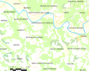
Castelnaud-la-Chapelle (Castelnaud-la-Chapelle)
- commune in Dordogne, France
- Country:

- Postal Code: 24250
- Coordinates: 44° 48' 54" N, 1° 8' 55" E


- GPS tracks (wikiloc): [Link]
- AboveSeaLevel: 71 м m
- Area: 20.88 sq km
- Population: 471
- Web site: http://www.castelnaud-la-chapelle.com/
- Wikipedia en: wiki(en)
- Wikipedia: wiki(fr)
- Wikidata storage: Wikidata: Q457785
- Wikipedia Commons Category: [Link]
- Freebase ID: [/m/03hf_p3]
- Freebase ID: [/m/03hf_p3]
- GeoNames ID: Alt: [6616149]
- GeoNames ID: Alt: [6616149]
- SIREN number: [212400865]
- SIREN number: [212400865]
- BnF ID: [15251736d]
- BnF ID: [15251736d]
- VIAF ID: Alt: [141045728]
- VIAF ID: Alt: [141045728]
- GND ID: Alt: [4350252-0]
- GND ID: Alt: [4350252-0]
- Library of Congress authority ID: Alt: [no99076252]
- Library of Congress authority ID: Alt: [no99076252]
- PACTOLS thesaurus ID: [pcrtlbfBsORBZV]
- PACTOLS thesaurus ID: [pcrtlbfBsORBZV]
- INSEE municipality code: 24086
- INSEE municipality code: 24086
Shares border with regions:


Grives
- commune in Dordogne, France
- Country:

- Postal Code: 24170
- Coordinates: 44° 45' 55" N, 1° 4' 36" E


- GPS tracks (wikiloc): [Link]
- Area: 8.12 sq km
- Population: 141


Allas-les-Mines
- commune in Dordogne, France
- Country:

- Postal Code: 24220
- Coordinates: 44° 50' 0" N, 1° 4' 20" E


- GPS tracks (wikiloc): [Link]
- Area: 7.04 sq km
- Population: 210


Beynac-et-Cazenac
- commune in Dordogne, France
- Country:

- Postal Code: 24220
- Coordinates: 44° 50' 24" N, 1° 8' 38" E


- GPS tracks (wikiloc): [Link]
- Area: 12.74 sq km
- Population: 552
- Web site: [Link]


Saint-Laurent-la-Vallée
- commune in Dordogne, France
- Country:

- Postal Code: 24170
- Coordinates: 44° 44' 56" N, 1° 6' 34" E


- GPS tracks (wikiloc): [Link]
- Area: 15.07 sq km
- Population: 265


Cénac-et-Saint-Julien
- commune in Dordogne, France
- Country:

- Postal Code: 24250
- Coordinates: 44° 48' 0" N, 1° 12' 16" E


- GPS tracks (wikiloc): [Link]
- Area: 19.87 sq km
- Population: 1201
- Web site: [Link]
