Castelnuovo di Ceva (Castelnuovo di Ceva)
- Italian comune
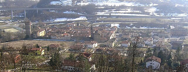
 Hiking in Castelnuovo di Ceva
Castelnuovo di Ceva is a charming municipality located in the Piedmont region of northern Italy, surrounded by beautiful landscapes that are perfect for hiking enthusiasts. Its proximity to the Alps and picturesque countryside offers a variety of trails, making it an appealing destination for hikers of all levels.
Hiking Trails
-
Langhe Hills Trails: The region is known for its rolling hills and vineyards, with trails that provide stunning views of the Langhe landscape. These paths often wind through charming villages, vineyards, and agricultural areas.
-
Mountain Trails: The nearby mountains offer more challenging hikes, including routes that take you up to higher elevations, providing panoramic views of the surrounding area. Look for trails leading into the nearby Alps or through local nature reserves.
-
Nature Reserves: Explore local nature reserves where you can enjoy the diversity of flora and fauna native to the region. Birdwatching and spotting wildlife can add to the hiking experience.
Preparation
- Seasonal Awareness: The best times for hiking in this area are usually from spring to early fall. Ensure you check the weather conditions and trail status.
- Gear: Make sure to wear sturdy hiking shoes, carry a backpack with water, snacks, and a map or a GPS device. Also, consider dressing in layers, as temperatures can vary throughout the day.
Local Attractions
After hiking, take some time to explore Castelnuovo di Ceva and its surroundings. The town features historical architecture and local cuisine, including traditional Piedmontese dishes. Visiting local vineyards for a wine tasting can also be a rewarding experience.
Safety Tips
- Always inform someone about your hiking plans.
- Stay on marked trails to avoid getting lost or disturbing the local ecosystem.
- Be aware of the difficulty level of the trails and choose one that suits your experience and fitness level.
Enjoy the natural beauty and tranquility that Castelnuovo di Ceva has to offer during your hiking adventures!
- Country:

- Postal Code: 12070
- Local Dialing Code: 0174
- Licence Plate Code: CN
- Coordinates: 44° 21' 0" N, 8° 8' 0" E


- GPS tracks (wikiloc): [Link]
- AboveSeaLevel: 743 м m
- Area: 6.26 sq km
- Population: 119
- Web site: http://www.comune.castelnuovodiceva.cn.it
- Wikipedia en: wiki(en)
- Wikipedia: wiki(it)
- Wikidata storage: Wikidata: Q19917
- Wikipedia Commons Category: [Link]
- Freebase ID: [/m/0gb8vm]
- GeoNames ID: Alt: [6543437]
- VIAF ID: Alt: [235262056]
- OSM relation ID: [43053]
- ISTAT ID: 004054
- Italian cadastre code: C214
Shares border with regions:
Montezemolo
- Italian comune
Hiking in Montezemolo
Montezemolo, located in the Piedmont region of Italy, offers a variety of hiking opportunities that showcase the beautiful landscapes, vineyards, and natural features of the area. Here are some aspects to consider when planning a hike there:...
- Country:
- Postal Code: 12070
- Local Dialing Code: 0174
- Licence Plate Code: CN
- Coordinates: 44° 23' 0" N, 8° 8' 0" E
- GPS tracks (wikiloc): [Link]
- AboveSeaLevel: 734 м m
- Area: 6.75 sq km
- Population: 252
- Web site: [Link]
Priero
- Italian comune
Hiking in Priero
Priero is a small municipality located in the province of Savona, in the Liguria region of Italy. While not as widely known as some other hiking destinations in the region, Priero offers beautiful natural landscapes and a tranquil environment for outdoor enthusiasts....
- Country:
- Postal Code: 12070
- Local Dialing Code: 0174
- Licence Plate Code: CN
- Coordinates: 44° 23' 0" N, 8° 6' 0" E
- GPS tracks (wikiloc): [Link]
- AboveSeaLevel: 475 м m
- Area: 20.01 sq km
- Population: 516
- Web site: [Link]


Murialdo
- Italian comune
Hiking in Murialdo
Murialdo is a small village located in the Liguria region of Italy, known for its beautiful landscapes and outdoor activities, including hiking. The surrounding area is characterized by a mix of lush forests, rolling hills, and stunning views, making it a great destination for hikers of all skill levels....
- Country:
- Postal Code: 17013
- Local Dialing Code: 019
- Licence Plate Code: SV
- Coordinates: 44° 18' 58" N, 8° 9' 41" E
- GPS tracks (wikiloc): [Link]
- AboveSeaLevel: 524 м m
- Area: 39.22 sq km
- Population: 837
- Web site: [Link]


Roccavignale
- Italian comune
Hiking in Roccavignale
Roccavignale is a charming village located in the province of Savona in the Liguria region of northwest Italy. The area is characterized by its stunning landscapes, rolling hills, and picturesque views, making it a great destination for hiking enthusiasts....
- Country:
- Postal Code: 17017
- Local Dialing Code: 019
- Licence Plate Code: SV
- Coordinates: 44° 21' 42" N, 8° 11' 34" E
- GPS tracks (wikiloc): [Link]
- AboveSeaLevel: 521 м m
- Area: 17.71 sq km
- Population: 766
- Web site: [Link]