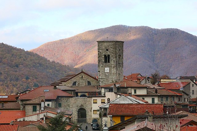
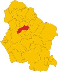
Castelnuovo di Garfagnana (Castelnuovo di Garfagnana)
.svg)
- Italian comune
 Hiking in Castelnuovo di Garfagnana
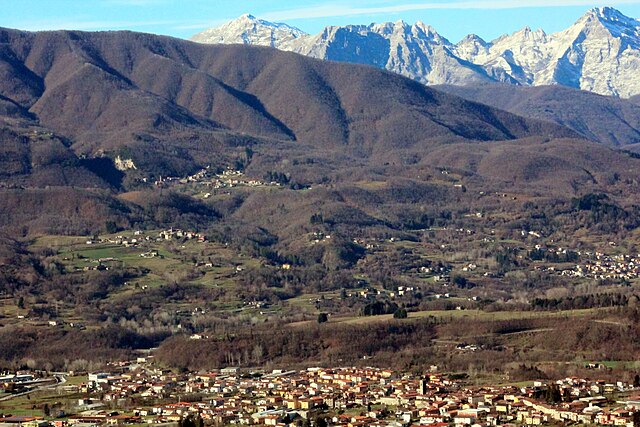
Castelnuovo di Garfagnana, located in the beautiful Garfagnana area of Tuscany, Italy, is an excellent destination for hiking enthusiasts. Surrounded by the stunning Apuan Alps and the Apennines, the region offers a variety of trails that cater to different skill levels, from easy walks to challenging hikes.
Highlights of Hiking in Castelnuovo di Garfagnana:
-
Diverse Landscapes: The area is characterized by lush valleys, rugged mountains, and picturesque medieval villages. Hikers can enjoy views of green hills, rivers, and historic castles along the way.
-
Trails and Paths:
- Sentiero del Volto: A popular trail that offers scenic views of the surrounding mountains and valleys. It’s suitable for beginners and takes you through charming landscapes.
- Monte Casoli: For those looking for a more challenging hike, ascending Monte Casoli provides breathtaking panoramic views. The trail can be steep and may take a few hours to complete.
- The Serchio Valley Trail: This moderate trail follows the Serchio River and features a combination of nature and cultural experiences, passing by small villages and historical sites.
-
Natural Parks: The nearby Apuan Alps Regional Park and Casentino Forests, Monte Falterona, and Campigna National Park offer extensive networks of hiking trails with various levels of difficulty, showcasing the region's rich biodiversity.
-
Historical Significance: Many trails lead to ancient villages, churches, and ruins, allowing hikers to experience the local culture and history. The town itself boasts historical architecture and quaint streets worth exploring.
-
Seasonal Variation: Each season presents a different hiking experience. Spring brings blooming wildflowers, summer offers lush greenery, autumn showcases vivid foliage, and winter provides opportunities for snowshoeing in higher elevations.
Tips for Hiking in Castelnuovo di Garfagnana:
- Local Guides: Consider hiring a local guide, especially if you’re unfamiliar with the area. They can offer insights and ensure you don’t miss any hidden gems.
- Weather: Always check the weather forecast before heading out, as conditions can change rapidly in mountainous areas.
- Gear: Wear appropriate footwear and bring plenty of water, snacks, and sunscreen. Weather-appropriate clothing is also crucial depending on the season.
- Respect Nature: Follow the "Leave No Trace" principles to preserve the natural beauty of the area.
Overall, hiking in Castelnuovo di Garfagnana is a rewarding way to experience the stunning landscapes and rich culture of this part of Tuscany. Whether you're an experienced hiker or a casual walker, there are plenty of trails to explore.
- Country:

- Postal Code: 55032
- Local Dialing Code: 0583
- Licence Plate Code: LU
- Coordinates: 44° 7' 19" N, 10° 24' 20" E


- GPS tracks (wikiloc): [Link]
- AboveSeaLevel: 270 м m
- Area: 28.48 sq km
- Population: 5936
- Web site: http://www.comune.castelnuovo-di-garfagnana.lu.it/
- Wikipedia en: wiki(en)
- Wikipedia: wiki(it)
- Wikidata storage: Wikidata: Q216903
- Wikipedia Commons Category: [Link]
- Freebase ID: [/m/0drrrm]
- GeoNames ID: Alt: [6541879]
- VIAF ID: Alt: [151013716]
- OSM relation ID: [42860]
- GND ID: Alt: [4381456-6]
- TGN ID: [1044058]
- UN/LOCODE: [ITC8G]
- ISTAT ID: 046009
- Italian cadastre code: C236
Shares border with regions:


Camporgiano
- Italian comune
Hiking in Camporgiano
Camporgiano is a charming village located in the Garfagnana region of Tuscany, Italy. This area is known for its stunning landscapes, including valleys, mountains, and rich natural flora and fauna, making it an excellent destination for hiking enthusiasts....
- Country:
- Postal Code: 55031
- Local Dialing Code: 0583
- Licence Plate Code: LU
- Coordinates: 44° 9' 39" N, 10° 20' 4" E
- GPS tracks (wikiloc): [Link]
- AboveSeaLevel: 475 м m
- Area: 27.09 sq km
- Population: 2137
- Web site: [Link]

Careggine
- Italian comune
Hiking in Careggine
Careggine, located in the Apuan Alps in Tuscany, Italy, is a beautiful destination for hiking enthusiasts. The region is characterized by stunning mountain landscapes, lush forests, and a variety of trails suitable for different skill levels....
- Country:
- Postal Code: 55030
- Local Dialing Code: 0583
- Licence Plate Code: LU
- Coordinates: 44° 7' 15" N, 10° 19' 35" E
- GPS tracks (wikiloc): [Link]
- AboveSeaLevel: 882 м m
- Area: 24.08 sq km
- Population: 539
- Web site: [Link]


Fosciandora
- Italian comune
Hiking in Fosciandora
Fosciandora is a small town located in the Lucca province of Tuscany, Italy. It offers a beautiful rural landscape ideal for hiking enthusiasts. The surrounding area features rolling hills, vineyards, olive groves, and stunning views of the Apuan Alps. Here are some insights for hiking in Fosciandora:...
- Country:
- Postal Code: 55020
- Local Dialing Code: 0583
- Licence Plate Code: LU
- Coordinates: 44° 6' 57" N, 10° 27' 34" E
- GPS tracks (wikiloc): [Link]
- AboveSeaLevel: 390 м m
- Area: 19.86 sq km
- Population: 584
- Web site: [Link]


Gallicano
- Italian comune
Hiking in Gallicano
Gallicano, located in the Garfagnana area of Tuscany, Italy, is a fantastic destination for hiking enthusiasts. Surrounded by the stunning Apuane Alps and lush natural landscapes, this region offers a variety of trails that cater to different skill levels....
- Country:
- Postal Code: 55027
- Local Dialing Code: 0583
- Licence Plate Code: LU
- Coordinates: 44° 4' 0" N, 10° 26' 0" E
- GPS tracks (wikiloc): [Link]
- AboveSeaLevel: 186 м m
- Area: 31.04 sq km
- Population: 3733
- Web site: [Link]

Molazzana
- Italian comune
Hiking in Molazzana
Molazzana is a small village located in the Garfagnana region of Tuscany, Italy. Surrounded by the beautiful Apuan Alps and rich in natural beauty, it offers various hiking trails that cater to different experience levels. Here are some highlights about hiking in Molazzana:...
- Country:
- Postal Code: 55020
- Local Dialing Code: 0583
- Licence Plate Code: LU
- Coordinates: 44° 4' 0" N, 10° 25' 0" E
- GPS tracks (wikiloc): [Link]
- AboveSeaLevel: 474 м m
- Area: 31.33 sq km
- Population: 1046
- Web site: [Link]

Pieve Fosciana
- Italian comune
Hiking in Pieve Fosciana
Pieve Fosciana is a charming village located in the Garfagnana region of Tuscany, Italy, surrounded by beautiful landscapes, making it an excellent destination for hiking enthusiasts. Here are some highlights and tips for hiking in and around Pieve Fosciana:...
- Country:
- Postal Code: 55036
- Local Dialing Code: 0583
- Licence Plate Code: LU
- Coordinates: 44° 7' 58" N, 10° 24' 43" E
- GPS tracks (wikiloc): [Link]
- AboveSeaLevel: 369 м m
- Area: 28.76 sq km
- Population: 2484
- Web site: [Link]