
Castro (Castro)
.svg)
- comune in the Province of Bergamo in the Italian region of Lombardy
 Hiking in Castro
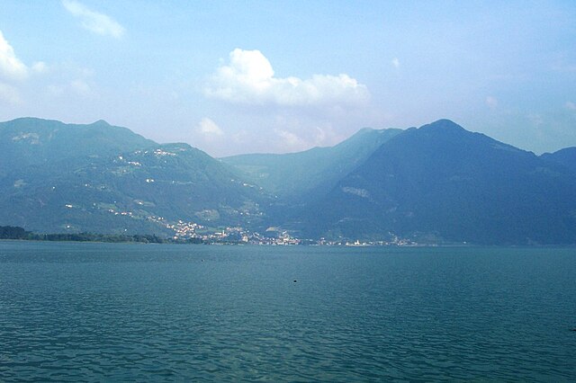
Hiking in Castro, a charming village located in the Lombardy region of Italy, offers stunning views and a variety of trails suitable for different skill levels. Nestled along the eastern shore of Lake Iseo, Castro provides a perfect blend of natural beauty, cultural richness, and outdoor activities.
Popular Hiking Trails:
-
Sentiero del Viandante: This historic trail runs along the lake's edge and offers breathtaking views of Lake Iseo and the surrounding mountains. The trail is well-marked and can be completed in sections, making it accessible for both beginners and experienced hikers.
-
Monte Guglielmo: A more challenging hike, the ascent to Monte Guglielmo rewards hikers with panoramic vistas of the entire region, including the lake and distant mountains. The trail winds through lush forests and offers opportunities for wildlife spotting.
-
Pathways to the Castles: There are several paths leading to historical sites, including old castles and fortifications nearby. These routes provide not only a workout but also a glimpse into the region's history and architecture.
Nature and Scenic Views:
- Lakeside Views: Many trails in the area provide stunning views of Lake Iseo. Stop at various viewpoints to fully appreciate the beauty of the landscape.
- Forests and Wildlife: The wooded areas are home to diverse flora and fauna, making it a great spot for nature enthusiasts and photographers.
Tips for Hiking in Castro:
- Best Time to Visit: Late spring and early autumn are ideal for hiking, as the weather is mild and the trails are less crowded.
- Gear Up: Wear suitable hiking boots and bring informed gear including a daypack, water, snacks, and sun protection.
- Respect Nature: Follow Leave No Trace principles to protect the stunning environment.
- Stay Hydrated: Ensure to bring enough water, especially on longer hikes, as some trails might not have water sources.
Local Attractions:
Aside from hiking, Castro offers other attractions, such as quaint streets, local restaurants serving traditional Lombard cuisine, and beautiful churches. The close proximity to other attractions such as the Franciacorta wine region and the Brescia countryside enhances the experience.
In summary, hiking in Castro, Lombardy, provides an excellent opportunity to explore the natural beauty of northern Italy while enjoying physical activity and cultural experiences. Whether you're a seasoned hiker or a casual walker, the trails around Castro have something to offer for everyone.
- Country:

- Postal Code: 24063
- Local Dialing Code: 035
- Licence Plate Code: BG
- Coordinates: 45° 48' 0" N, 10° 4' 0" E


- GPS tracks (wikiloc): [Link]
- AboveSeaLevel: 200 м m
- Area: 2.59 sq km
- Population: 1306
- Web site: http://www.comune.castro.bg.it
- Wikipedia en: wiki(en)
- Wikipedia: wiki(it)
- Wikidata storage: Wikidata: Q100192
- Wikipedia Commons Category: [Link]
- Freebase ID: [/m/0gj9j5]
- GeoNames ID: Alt: [6539783]
- OSM relation ID: [81516]
- ISTAT ID: 016065
- Italian cadastre code: C337
Shares border with regions:


Lovere
- Italian comune
Hiking in Lovere
Lovere, a picturesque town located on the shores of Lake Iseo in northern Italy, offers a fantastic backdrop for hiking enthusiasts. The surrounding area is characterized by stunning landscapes, lush greenery, and charming villages. Here are some highlights and tips for hiking in and around Lovere:...
- Country:
- Postal Code: 24065
- Local Dialing Code: 035
- Licence Plate Code: BG
- Coordinates: 45° 48' 45" N, 10° 4' 12" E
- GPS tracks (wikiloc): [Link]
- AboveSeaLevel: 208 м m
- Area: 7.92 sq km
- Population: 5224
- Web site: [Link]


Pianico
- Italian comune
Hiking in Pianico
Pianico is a picturesque village located in the province of Bergamo, in the Lombardy region of Italy. It is surrounded by the stunning landscapes of the Italian Alps, making it an excellent destination for hiking enthusiasts. Here are some key points about hiking in and around Pianico:...
- Country:
- Postal Code: 24060
- Local Dialing Code: 035
- Licence Plate Code: BG
- Coordinates: 45° 48' 38" N, 10° 2' 38" E
- GPS tracks (wikiloc): [Link]
- AboveSeaLevel: 328 м m
- Area: 2.7 sq km
- Population: 1452
- Web site: [Link]


Solto Collina
- Italian comune
Hiking in Solto Collina
Solto Collina is a charming destination located near Lake Iseo in Italy, offering a variety of hiking opportunities amidst beautiful landscapes, lush greenery, and panoramic views of the lake and surrounding mountains....
- Country:
- Postal Code: 24060
- Local Dialing Code: 035
- Licence Plate Code: BG
- Coordinates: 45° 47' 0" N, 10° 1' 0" E
- GPS tracks (wikiloc): [Link]
- AboveSeaLevel: 449 м m
- Area: 11.76 sq km
- Population: 1799
- Web site: [Link]
Pisogne
- Italian comune
Hiking in Pisogne
Pisogne is a charming town located along the eastern shore of Lake Iseo in Italy's Lombardy region. It offers a myriad of hiking opportunities for outdoor enthusiasts, featuring beautiful landscapes, scenic views of the lake, and the surrounding mountains. Here are some highlights about hiking in and around Pisogne:...
- Country:
- Postal Code: 25055
- Local Dialing Code: 0364
- Licence Plate Code: BS
- Coordinates: 45° 48' 39" N, 10° 6' 29" E
- GPS tracks (wikiloc): [Link]
- AboveSeaLevel: 187 м m
- Area: 49.23 sq km
- Population: 7982
- Web site: [Link]