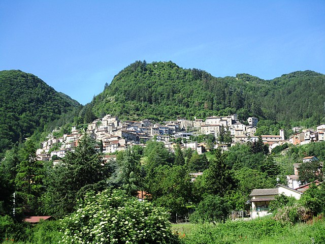
Cervara di Roma (Cervara di Roma)
.svg)
- Italian comune
 Hiking in Cervara di Roma
Cervara di Roma is a charming mountain village located in the Apennines, known for its stunning landscapes, rich history, and excellent hiking opportunities. Here are some highlights about hiking in and around Cervara di Roma:
Scenic Trails
-
Sentiero degli Dei: This beautiful trail offers breathtaking views of the surrounding mountains and valleys, making it a popular choice for both novice and experienced hikers.
-
Monte Tarino: A hike to Monte Tarino provides stunning panoramic views and is a great way to experience the natural beauty of the area. The trail is well-marked and takes you through forests and rocky terrains.
-
Cervara to Civitella: This hiking route connects Cervara di Roma to the nearby town of Civitella, offering both an enjoyable walk and a chance to explore another picturesque village.
Flora and Fauna
The area around Cervara di Roma boasts diverse flora and fauna. Hikers can often see a variety of plants, trees, and wildlife, including birds and small mammals. Spring and summer months are particularly vibrant.
Historical Significance
Cervara di Roma itself is steeped in history, with medieval architecture and churches dotting the landscape. Incorporating a bit of cultural exploration into your hiking can enhance the overall experience. You might want to visit historical sites like the Church of Santa Maria Assunta.
Practical Tips
- Best Time to Hike: Spring (April to June) and early autumn (September to October) are ideal for hiking, as the weather is pleasant and the landscapes are lush.
- Gear: Ensure you have good hiking boots, plenty of water, and snacks. A map or GPS device can be very helpful, as some trails may not be well-marked.
- Local Guides: If you're unfamiliar with the area, consider hiring a local guide. They can provide valuable insights into both the trails and the history of Cervara di Roma.
Safety Considerations
- Always check the weather before heading out.
- Inform someone of your hiking plans, especially if hiking alone.
- Follow trail markers and respect local wildlife and plants.
Hiking in Cervara di Roma offers a delightful mix of nature, scenery, and culture, making it a rewarding experience for outdoor enthusiasts and those looking to explore Italy's beautiful landscapes. Enjoy your adventure!
- Country:

- Postal Code: 00020
- Local Dialing Code: 0774
- Licence Plate Code: RM
- Coordinates: 41° 59' 17" N, 13° 4' 2" E


- GPS tracks (wikiloc): [Link]
- AboveSeaLevel: 1053 м m
- Area: 31.75 sq km
- Population: 438
- Web site: http://www.comune.cervaradiroma.rm.it/
- Wikipedia en: wiki(en)
- Wikipedia: wiki(it)
- Wikidata storage: Wikidata: Q242133
- Wikipedia Commons Category: [Link]
- Freebase ID: [/m/0gm72y]
- GeoNames ID: Alt: [6538672]
- VIAF ID: Alt: [240080042]
- OSM relation ID: [41679]
- MusicBrainz area ID: [9711ebe4-6e67-4678-a393-0b029197a39c]
- ISTAT ID: 058028
- Italian cadastre code: C543
Shares border with regions:


Agosta, Lazio
- Italian comune
Hiking in Agosta, Lazio
Agosta, a charming town located in the Lazio region of Italy, is nestled in the Aniene Valley and offers beautiful landscapes and outdoor activities, making it a great destination for hiking enthusiasts. Here are some key points to consider when hiking in and around Agosta:...
- Country:
- Postal Code: 00020
- Local Dialing Code: 0774
- Licence Plate Code: ROMA
- Coordinates: 41° 58' 57" N, 13° 2' 1" E
- GPS tracks (wikiloc): [Link]
- AboveSeaLevel: 392 м m
- Area: 9.5 sq km
- Population: 1742
- Web site: [Link]


Arsoli
- Italian comune
Hiking in Arsoli
Arsoli is a charming village located in the province of Rome, Italy, and is surrounded by beautiful natural landscapes that offer fantastic hiking opportunities. Nestled in the Simbruini Mountains, the area is characterized by its rugged terrain, lush forests, and stunning views, making it an excellent destination for outdoor enthusiasts....
- Country:
- Postal Code: 00023
- Local Dialing Code: 0774
- Licence Plate Code: RM
- Coordinates: 42° 2' 26" N, 13° 1' 4" E
- GPS tracks (wikiloc): [Link]
- AboveSeaLevel: 470 м m
- Area: 12.2 sq km
- Population: 1534
- Web site: [Link]
Camerata Nuova
- Italian comune
Hiking in Camerata Nuova
Camerata Nuova is a charming village located in the province of Rome, Italy, nestled within the beautiful landscape of the Apennine Mountains. This area is known for its natural beauty, making it a fantastic destination for hiking enthusiasts....
- Country:
- Postal Code: 00020
- Local Dialing Code: 0774
- Licence Plate Code: RM
- Coordinates: 42° 1' 0" N, 13° 6' 0" E
- GPS tracks (wikiloc): [Link]
- AboveSeaLevel: 810 м m
- Area: 40.5 sq km
- Population: 445
- Web site: [Link]


Marano Equo
- Italian comune
Hiking in Marano Equo
Marano Equo is a charming village located in the Roman province of Lazio, Italy, nestled in the Aniene Valley and surrounded by the beautiful Sabine Mountains. Hiking around this area offers a mix of stunning natural landscapes, historical sites, and traditional Italian culture. Here are some highlights and tips for hiking in Marano Equo:...
- Country:
- Postal Code: 00020
- Local Dialing Code: 0774
- Licence Plate Code: RM
- Coordinates: 41° 59' 38" N, 13° 1' 0" E
- GPS tracks (wikiloc): [Link]
- AboveSeaLevel: 450 м m
- Area: 7.65 sq km
- Population: 783
- Web site: [Link]


Subiaco
- Italian comune
Hiking in Subiaco
Subiaco, located in the Lazio region of Italy, is known for its stunning natural landscapes, rich history, and numerous hiking opportunities. It is situated in the Aniene Valley, surrounded by the Simbruini Mountains, making it a great base for hiking enthusiasts. Here’s what you should know about hiking in Subiaco:...
- Country:
- Postal Code: 00028
- Local Dialing Code: 0774
- Licence Plate Code: RM
- Coordinates: 41° 56' 0" N, 13° 6' 0" E
- GPS tracks (wikiloc): [Link]
- AboveSeaLevel: 408 м m
- Area: 63.23 sq km
- Population: 8916
- Web site: [Link]

Rocca di Botte
- Italian comune
Hiking in Rocca di Botte
Rocca di Botte is a charming mountain village located in the Abruzzo region of Italy, nestled in the scenic Apennine Mountains. The area is known for its stunning natural landscapes, rich biodiversity, and opportunities for outdoor activities, particularly hiking....
- Country:
- Postal Code: 67066
- Local Dialing Code: 0863
- Licence Plate Code: AQ
- Coordinates: 42° 1' 38" N, 13° 4' 7" E
- GPS tracks (wikiloc): [Link]
- AboveSeaLevel: 750 м m
- Area: 31.1 sq km
- Population: 842
- Web site: [Link]