Châteaugiron (Châteaugiron)
- former commune in Ille-et-Vilaine, France
- Country:

- Postal Code: 35410
- Coordinates: 48° 2' 53" N, 1° 30' 11" E


- GPS tracks (wikiloc): [Link]
- Area: 8.7 sq km
- Population: 7522
- Web site: http://www.ville-chateaugiron.fr
- Wikidata storage: Wikidata: Q380027
- Wikipedia Commons Category: [Link]
- Freebase ID: [/m/03mdxn0]
- GeoNames ID: Alt: [6448548]
- SIREN number: [200064483]
- BnF ID: [152570138]
- VIAF ID: Alt: [235681464]
- WOEID: [584955]
- Twitter username: Alt: [chateaugiron]
- INSEE municipality code: 35069
Shares border with regions:

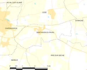
Saint-Aubin-du-Pavail
- former commune in Ille-et-Vilaine, France
- Country:
- Postal Code: 35410
- Coordinates: 48° 2' 37" N, 1° 27' 41" E
- GPS tracks (wikiloc): [Link]
- Area: 5.83 sq km
- Population: 854
- Web site: [Link]


Nouvoitou
- commune in Ille-et-Vilaine, France
- Country:
- Postal Code: 35410
- Coordinates: 48° 2' 26" N, 1° 32' 45" E
- GPS tracks (wikiloc): [Link]
- Area: 18.93 sq km
- Population: 2932
- Web site: [Link]

Domloup
- commune in Ille-et-Vilaine, France
- Country:
- Postal Code: 35410
- Coordinates: 48° 3' 43" N, 1° 31' 23" E
- GPS tracks (wikiloc): [Link]
- AboveSeaLevel: 60 м m
- Area: 18.91 sq km
- Population: 3185
- Web site: [Link]


Noyal-sur-Vilaine
- commune in Ille-et-Vilaine, France
- Country:
- Postal Code: 35530
- Coordinates: 48° 6' 42" N, 1° 31' 28" E
- GPS tracks (wikiloc): [Link]
- Area: 30.36 sq km
- Population: 5820
- Web site: [Link]


Ossé
- former commune in Ille-et-Vilaine, France
- Country:
- Postal Code: 35410
- Coordinates: 48° 3' 20" N, 1° 27' 1" E
- GPS tracks (wikiloc): [Link]
- Area: 8.99 sq km
- Population: 1185
- Web site: [Link]


Amanlis
- commune in Ille-et-Vilaine, France
- Country:
- Postal Code: 35150
- Coordinates: 48° 0' 23" N, 1° 28' 34" E
- GPS tracks (wikiloc): [Link]
- Area: 25.25 sq km
- Population: 1688