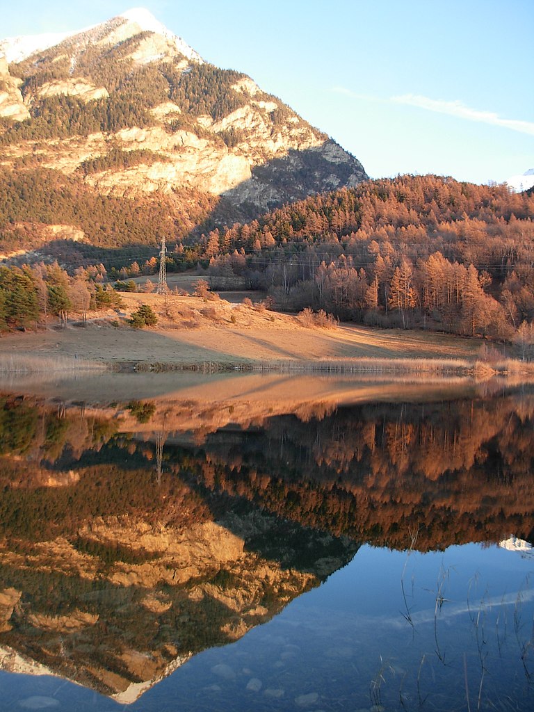
Châteauroux-les-Alpes (Châteauroux-les-Alpes)
- commune in Hautes-Alpes, France
 Hiking in Châteauroux-les-Alpes
Châteauroux-les-Alpes is a charming village located in the Hautes-Alpes department in southeastern France. It is surrounded by beautiful mountainous landscapes, making it a great base for hiking enthusiasts. Here are some highlights of hiking in and around Châteauroux-les-Alpes:
Scenic Trails
-
Valley of the Durance: Several trails lead along the Durance River, offering picturesque views of the valley and surrounding peaks. The terrain varies from easy walks to more challenging routes.
-
Col de la Croix: This area offers various hiking paths leading to spectacular viewpoints and opportunities for photography, especially during sunrise or sunset.
-
Montagne de Châteauroux: You can find trails that lead up to higher elevations, providing panoramic views of the surrounding Alps and the opportunity to encounter diverse flora and fauna.
Nature and Wildlife
The region is rich in biodiversity, so be on the lookout for local wildlife like deer, marmots, and a variety of bird species. The diverse ecosystems provide a lively experience for nature lovers.
Tips for Hiking in Châteauroux-les-Alpes
- Seasonal Considerations: Depending on the time of year, some trails may be covered with snow, so check the weather and trail conditions before heading out.
- Local Maps and Guides: Consider picking up local hiking maps or hiring a guide if you're unfamiliar with the area. This can enhance your experience significantly.
- Hydration and Gear: Always carry enough water and snacks, wear appropriate footwear, and dress in layers to adapt to the changing weather conditions in the mountains.
Accessibility
Châteauroux-les-Alpes is accessible by car and offers various accommodation options ranging from camping sites to cozy inns. This accessibility makes it a convenient starting point for exploring the Alps.
Overall, hiking in Châteauroux-les-Alpes provides an opportunity to immerse yourself in nature, enjoy the stunning landscapes, and experience the serene beauty of the French Alps. Whether you are a beginner or an experienced hiker, there are trails catering to various skill levels.
- Country:

- Postal Code: 05380
- Coordinates: 44° 36' 52" N, 6° 31' 19" E


- GPS tracks (wikiloc): [Link]
- Area: 92.84 sq km
- Population: 1146
- Wikipedia en: wiki(en)
- Wikipedia: wiki(fr)
- Wikidata storage: Wikidata: Q518200
- Wikipedia Commons Category: [Link]
- Freebase ID: [/m/03mflfm]
- Freebase ID: [/m/03mflfm]
- GeoNames ID: Alt: [6618137]
- GeoNames ID: Alt: [6618137]
- SIREN number: [210500369]
- SIREN number: [210500369]
- PACTOLS thesaurus ID: [pcrtaaZeiBreKR]
- PACTOLS thesaurus ID: [pcrtaaZeiBreKR]
- INSEE municipality code: 05036
- INSEE municipality code: 05036
Shares border with regions:
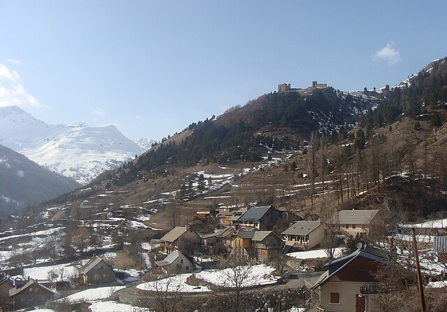
Champcella
- commune in Hautes-Alpes, France
Hiking in Champcella
Champcella is a lesser-known but beautiful hiking destination located in the French Alps, specifically in the Isère department. It's an excellent spot for nature lovers and those seeking adventure in mountain landscapes. Here are some key aspects to consider when hiking in Champcella:...
- Country:
- Postal Code: 05310
- Coordinates: 44° 43' 22" N, 6° 34' 17" E
- GPS tracks (wikiloc): [Link]
- AboveSeaLevel: 1150 м m
- Area: 30.25 sq km
- Population: 182

Orcières
- commune in Hautes-Alpes, France
Hiking in Orcières
Orcières is a stunning destination located in the French Alps, nestled within the Écrins National Park in the Haute-Alpes region. It offers a variety of hiking opportunities suitable for all levels of experience. Here are some key points to consider:...
- Country:
- Postal Code: 05170
- Coordinates: 44° 41' 4" N, 6° 19' 30" E
- GPS tracks (wikiloc): [Link]
- Area: 98.27 sq km
- Population: 715

Réotier
- commune in Hautes-Alpes, France
Hiking in Réotier
Réotier is a charming village located in the Hautes-Alpes region of France, near the border of Italy. It is nestled in the stunning natural landscape, characterized by mountains, rivers, and diverse flora and fauna, making it an excellent destination for hiking enthusiasts....
- Country:
- Postal Code: 05600
- Coordinates: 44° 39' 50" N, 6° 35' 24" E
- GPS tracks (wikiloc): [Link]
- Area: 22.33 sq km
- Population: 193
- Web site: [Link]
Saint-André-d'Embrun
- commune in Hautes-Alpes, France
Hiking in Saint-André-d'Embrun
Saint-André-d'Embrun is a charming village located in the southeastern part of France, nestled in the Hautes-Alpes region. It offers a variety of hiking opportunities that cater to different experience levels, making it a great destination for outdoor enthusiasts....
- Country:
- Postal Code: 05200
- Coordinates: 44° 35' 10" N, 6° 32' 2" E
- GPS tracks (wikiloc): [Link]
- Area: 38.63 sq km
- Population: 644
Réallon
- commune in Hautes-Alpes, France
Hiking in Réallon
Réallon is a picturesque village located in the French Alps, particularly in the Hautes-Alpes department. It’s a fantastic destination for hiking enthusiasts, offering a mix of stunning landscapes, diverse trails, and breathtaking views of the surrounding mountains and lakes. Here are some key details to consider when hiking in Réallon:...
- Country:
- Postal Code: 05160
- Coordinates: 44° 35' 44" N, 6° 21' 53" E
- GPS tracks (wikiloc): [Link]
- Area: 71.4 sq km
- Population: 260
- Web site: [Link]

Freissinières
- commune in Hautes-Alpes, France
Hiking in Freissinières
Freissinières is a picturesque village located in the Écrins National Park in the French Alps, renowned for its stunning landscapes, rich biodiversity, and a variety of hiking opportunities. Here's an overview to help you make the most of your hiking experience in Freissinières:...
- Country:
- Postal Code: 05310
- Coordinates: 44° 45' 15" N, 6° 32' 14" E
- GPS tracks (wikiloc): [Link]
- AboveSeaLevel: 1190 м m
- Area: 88.21 sq km
- Population: 208
- Web site: [Link]

Embrun
- commune in Hautes-Alpes, France
Hiking in Embrun
Embrun, located in the Hautes-Alpes region of France, is a fantastic destination for hiking enthusiasts. Nestled in the French Alps, the area boasts stunning landscapes, diverse flora and fauna, and a variety of trails suitable for all skill levels....
- Country:
- Postal Code: 05200
- Coordinates: 44° 33' 54" N, 6° 29' 43" E
- GPS tracks (wikiloc): [Link]
- AboveSeaLevel: 1789 м m
- Area: 36.39 sq km
- Population: 6177
- Web site: [Link]

Saint-Clément-sur-Durance
- commune in Hautes-Alpes, France
Hiking in Saint-Clément-sur-Durance
Saint-Clément-sur-Durance, located in the Hautes-Alpes region of France, offers a variety of hiking opportunities amidst stunning natural scenery. The area is characterized by its picturesque landscapes, including mountains, rivers, and quaint villages. Here are some key points to consider for hiking in this area:...
- Country:
- Postal Code: 05600
- Coordinates: 44° 38' 56" N, 6° 34' 42" E
- GPS tracks (wikiloc): [Link]
- AboveSeaLevel: 872 м m
- Area: 25.06 sq km
- Population: 291