Châtenay (Châtenay)
- commune in Isère, France
Châtenay is a charming commune located in the Isère department of the Auvergne-Rhône-Alpes region in southeastern France. While it may not be as well-known for hiking as some of the larger national parks or mountain ranges in the area, it offers several opportunities for outdoor activities, including hiking.
Hiking Trails and Areas
-
Local Paths: Châtenay itself is surrounded by beautiful natural landscapes, featuring a variety of local trails that can be explored. These paths often showcase the serene beauty of the Isère countryside, with opportunities to see local flora and fauna.
-
Nearby Parks: The Chartreuse Regional Natural Park and the Vercors Regional Natural Park are relatively close to Châtenay. These parks offer extensive networks of well-marked hiking trails ranging from easy walks to challenging hikes, with stunning views of the mountains and valleys.
-
Lac de Champos: Just a short drive away, this lake offers picturesque trails around its banks, ideal for a leisurely hike or a picnic with a view.
Tips for Hiking in the Area
-
Preparation: Always check the weather and trail conditions before heading out. Bring appropriate gear, including sturdy hiking boots, water, and snacks.
-
Maps and Information: Use a good hiking map or a mobile app to guide you along the trails as signage can sometimes be sparse.
-
Respect Nature: Stay on marked trails and follow the Leave No Trace principles to preserve the environment.
-
Wildlife: Be mindful of local wildlife and observe them from a distance without disturbing them.
Local Culture and Attractions
After your hike, take the opportunity to explore the local culture. Châtenay and its surrounding areas boast quaint villages, local cuisine, and historical sites that reflect the region's rich heritage. Consider visiting local markets or tasting regional specialties.
Conclusion
Hiking in and around Châtenay can provide a peaceful retreat into nature where you can enjoy the beauty of the Isère landscape. Whether you prefer a casual stroll or a more ambitious hike, there are options to suit various levels of fitness and experience. Always prioritize safety and enjoyment during your outdoor adventures!
- Country:

- Postal Code: 38980
- Coordinates: 45° 19' 14" N, 5° 13' 45" E


- GPS tracks (wikiloc): [Link]
- Area: 4.62 sq km
- Population: 442
- Wikipedia en: wiki(en)
- Wikipedia: wiki(fr)
- Wikidata storage: Wikidata: Q1003927
- Wikipedia Commons Category: [Link]
- Freebase ID: [/m/03nvgrf]
- GeoNames ID: Alt: [6455084]
- SIREN number: [213800931]
- INSEE municipality code: 38093
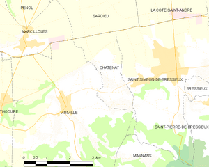
Shares border with regions:


Saint-Siméon-de-Bressieux
- commune in Isère, France
 Hiking in Saint-Siméon-de-Bressieux
Saint-Siméon-de-Bressieux is a charming village located in the Isère department in the Auvergne-Rhône-Alpes region of France. The surrounding area offers stunning natural landscapes, making it an excellent spot for hiking enthusiasts....
- Country:

- Postal Code: 38870
- Coordinates: 45° 19' 42" N, 5° 15' 42" E


- GPS tracks (wikiloc): [Link]
- Area: 18.79 sq km
- Population: 2876
- Web site: [Link]


Marnans
- commune in Isère, France
Marnans, a picturesque area known for its stunning landscapes, offers a variety of hiking opportunities suitable for different skill levels. Whether you are a beginner or an experienced hiker, the region has something for everyone....
- Country:

- Postal Code: 38980
- Coordinates: 45° 17' 41" N, 5° 14' 14" E


- GPS tracks (wikiloc): [Link]
- Area: 6.6 sq km
- Population: 152


Sardieu
- commune in Isère, France
Sardieu is a beautiful destination for hiking, located in the Isère department of France, near the foothills of the Alps. This region is known for its scenic landscapes, diverse terrain, and beautiful views, making it a great spot for outdoor enthusiasts....
- Country:

- Postal Code: 38260
- Coordinates: 45° 22' 9" N, 5° 12' 43" E


- GPS tracks (wikiloc): [Link]
- AboveSeaLevel: 358 м m
- Area: 11.2 sq km
- Population: 1097
- Web site: [Link]


Viriville
- commune in Isère, France
Viriville is a charming village located in the Isère department of France, nestled in the breathtaking backdrop of the French Alps. Hiking in this region offers an incredible experience, with its stunning landscapes, diverse flora and fauna, and a variety of trails suitable for different skill levels....
- Country:

- Postal Code: 38980
- Coordinates: 45° 18' 57" N, 5° 12' 15" E


- GPS tracks (wikiloc): [Link]
- Area: 30.46 sq km
- Population: 1634
- Web site: [Link]
