Châtillon-sur-Lison (Châtillon-sur-Lison)

- commune in Doubs, France
 Hiking in Châtillon-sur-Lison
Châtillon-sur-Lison, located in the Franche-Comté region of eastern France, offers a delightful setting for hiking enthusiasts. The area is characterized by its lush landscapes, scenic valleys, and a mix of natural and historical features. Here are some highlights and tips for hiking in Châtillon-sur-Lison:
Trails and Routes
-
The Lison River Trail: This picturesque path follows the winding Lison River, offering serene views of the water and surrounding landscapes. Expect a moderate trail suitable for most hikers.
-
Mount Poupet: Ascending this nearby mountain provides an excellent hiking opportunity, with trails leading to the summit. From the top, you can enjoy panoramic views of the Jura and the surrounding countryside.
-
Caves and Grottos: The region is known for its geological features, including caves around the area. Some trails may lead to these fascinating natural sites, adding a sense of adventure to your hike.
-
Heritage Trails: Explore the cultural heritage of the region by hiking routes that take you through traditional villages, old farms, and historic landmarks.
Best Time to Hike
- Spring and Fall: These seasons are ideal for hiking, as the weather is usually mild and the landscapes are vibrant with blooming flowers in spring or colorful foliage in fall.
Preparation and Tips
- Footwear: Make sure to wear sturdy hiking boots, as some trails can be uneven or rocky.
- Maps and Guides: While many trails are well-marked, it’s advisable to carry a map or a GPS device, especially if you’re venturing into less traveled areas.
- Hydration and Snacks: Bring enough water and snacks to keep your energy up throughout your hike.
- Weather Check: Always check the local weather forecast before your hike, as conditions can change quickly in mountainous regions.
Local Attractions
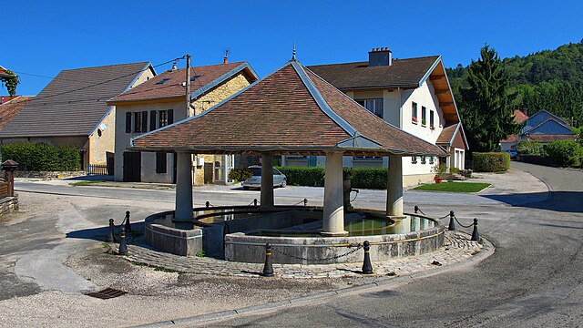
- Châtillon-sur-Lison: Take some time to explore the village itself, with its charming architecture and local shops.
- Nearby Attractions: If you have extra time, consider visiting the nearby towns of Ornans, known for its connection to the painter Gustave Courbet, or the impressive citadel in Besançon.
Hiking in Châtillon-sur-Lison allows you to connect with nature and enjoy the stunning scenery the region has to offer. Whether you're a seasoned hiker or new to the sport, there's something for everyone in this beautiful part of France.
- Country:

- Postal Code: 25440
- Coordinates: 47° 3' 50" N, 5° 58' 56" E


- GPS tracks (wikiloc): [Link]
- AboveSeaLevel: 294 м m
- Area: 2.89 sq km
- Population: 9
- Wikipedia en: wiki(en)
- Wikipedia: wiki(fr)
- Wikidata storage: Wikidata: Q838898
- Wikipedia Commons Category: [Link]
- Freebase ID: [/m/03mgs04]
- Freebase ID: [/m/03mgs04]
- GeoNames ID: Alt: [6616205]
- GeoNames ID: Alt: [6616205]
- SIREN number: [212501340]
- SIREN number: [212501340]
- BnF ID: [15252360d]
- BnF ID: [15252360d]
- INSEE municipality code: 25134
- INSEE municipality code: 25134
Shares border with regions:
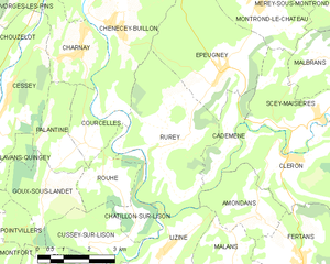
Rurey
- commune in Doubs, France
Hiking in Rurey
It seems like there might be a little confusion with the name "Rurey," as it's not widely recognized as a hiking destination. However, if you're referring to a specific area or region, please provide more context or correct the name, and I'll be happy to give you detailed information....
- Country:
- Postal Code: 25290
- Coordinates: 47° 5' 47" N, 6° 0' 33" E
- GPS tracks (wikiloc): [Link]
- Area: 14.77 sq km
- Population: 333


Rouhe
- commune in Doubs, France
Hiking in Rouhe
Rouhe, known for its beautiful landscapes and tranquil nature, offers a variety of hiking opportunities for all skill levels. While specific trails and routes may vary, here are some general tips and information to consider when hiking in this area:...
- Country:
- Postal Code: 25440
- Coordinates: 47° 4' 59" N, 5° 57' 50" E
- GPS tracks (wikiloc): [Link]
- Area: 4.19 sq km
- Population: 85