Chambon-sur-Cisse (Chambon-sur-Cisse)

- former commune in Loir-et-Cher, France
- Country:

- Postal Code: 41190
- Coordinates: 47° 33' 45" N, 1° 12' 57" E


- GPS tracks (wikiloc): [Link]
- Area: 12.71 sq km
- Population: 671
- Wikipedia en: wiki(en)
- Wikipedia: wiki(fr)
- Wikidata storage: Wikidata: Q647089
- Wikipedia Commons Category: [Link]
- Freebase ID: [/m/03nv_87]
- GeoNames ID: Alt: [3027370]
- BnF ID: [15259309b]
- INSEE municipality code: 41033
Shares border with regions:

Chouzy-sur-Cisse
- former commune in Loir-et-Cher, France
- Country:
- Postal Code: 41150
- Coordinates: 47° 31' 31" N, 1° 14' 50" E
- GPS tracks (wikiloc): [Link]
- Area: 22.43 sq km
- Population: 2027
- Web site: [Link]
Seillac
- former commune in Loir-et-Cher, France
- Country:
- Postal Code: 41150
- Coordinates: 47° 32' 42" N, 1° 9' 26" E
- GPS tracks (wikiloc): [Link]
- Area: 9.58 sq km
- Population: 107
Orchaise
- former commune in Loir-et-Cher, France
- Country:
- Postal Code: 41190
- Coordinates: 47° 35' 24" N, 1° 11' 56" E
- GPS tracks (wikiloc): [Link]
- Area: 20.03 sq km
- Population: 976
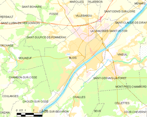
Blois
- commune in Loir-et-Cher, France
- Country:
- Postal Code: 41000
- Coordinates: 47° 35' 35" N, 1° 19' 38" E
- GPS tracks (wikiloc): [Link]
- AboveSeaLevel: 73 м m
- Area: 37.46 sq km
- Population: 45710
- Web site: [Link]


Coulanges
- former commune in Loir-et-Cher, France
- Country:
- Postal Code: 41150
- Coordinates: 47° 32' 35" N, 1° 13' 23" E
- GPS tracks (wikiloc): [Link]
- Area: 8.35 sq km
- Population: 328