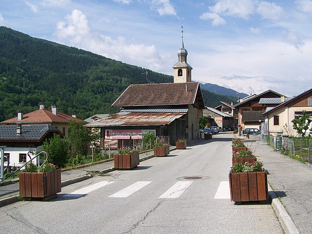
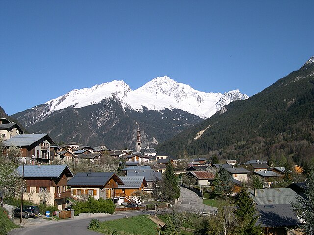
Champagny-en-Vanoise (Champagny-en-Vanoise)

- commune in Savoie, France
 Hiking in Champagny-en-Vanoise
Champagny-en-Vanoise is a picturesque village located in the Savoie region of the French Alps, and it serves as a fantastic base for hiking enthusiasts exploring the Vanoise National Park. The area is known for its stunning mountain scenery, diverse flora and fauna, and well-marked hiking trails suitable for all skill levels. Here are some key points about hiking in Champagny-en-Vanoise:
Hiking Trails
-
Variety of Trails: The trails range from easy strolls suitable for families to challenging hikes for seasoned trekkers. You can find routes that lead to alpine meadows, glacial lakes, and panoramic viewpoints.
-
Vanoise National Park: The proximity to the Vanoise National Park (the first national park established in France in 1963) means you'll have access to a wealth of natural beauty. Trails in the park often lead to breathtaking lakes like Lac de la Plagne or the iconic Col de la Vanoise.
-
Local Favorites: Popular hikes include the trail to the "Refuge de la Glière," where you can enjoy traditional mountain cuisine or the hike to the "Glacier de la Vanoise" for those seeking dramatic landscapes.
Seasonal Hiking
-
Summer and Autumn: The best time for hiking in Champagny-en-Vanoise is from late June through early October, when the weather is mild, and trails are clear of snow. Autumn is particularly beautiful with colorful foliage.
-
Winter: While summer is prime hiking season, winter provides opportunities for snowshoeing and ski touring if you're interested in winter sports.
Wildlife and Nature
- This region is home to diverse wildlife, including chamois, ibex, marmots, and numerous bird species. It's a great opportunity for wildlife enthusiasts to spot these animals in their natural habitats.
Tips for Hikers
-
Preparation: Always check trail conditions and weather forecasts before heading out. Prepare adequately with maps, proper gear, and enough food and water.
-
Guided Tours: If you prefer a guided experience, numerous local guides and tour companies offer excursions into the park.
-
Cultural Experience: Don’t miss the chance to explore the village itself, which has a rich alpine culture and offers local delicacies to try after a day's hike.
Safety Considerations
- Altitude: Some trails can reach significant altitudes, so be prepared for changes in weather and be aware of altitude sickness.
- Respect Nature: Follow ‘Leave No Trace’ principles to preserve the beauty of the environment.
In summary, hiking in Champagny-en-Vanoise offers an exceptional way to connect with nature, enjoy breathtaking views, and experience the charm of the French Alps. Whether you're an experienced hiker or a beginner, the region has something to offer everyone.
- Country:

- Postal Code: 73350
- Coordinates: 45° 27' 16" N, 6° 41' 33" E


- GPS tracks (wikiloc): [Link]
- Area: 84.96 sq km
- Population: 605
- Web site: http://www.mairie-champagny.com
- Wikipedia en: wiki(en)
- Wikipedia: wiki(fr)
- Wikidata storage: Wikidata: Q1242281
- Wikipedia Commons Category: [Link]
- Freebase ID: [/m/03cc02d]
- GeoNames ID: Alt: [6617572]
- SIREN number: [217300714]
- BnF ID: [15274005b]
- VIAF ID: Alt: [241882849]
- INSEE municipality code: 73071
Shares border with regions:

Bellentre
- former commune in Savoie, France
Hiking in Bellentre
Bellentre is a charming commune located in the Savoie department of the Auvergne-Rhône-Alpes region in southeastern France. It’s situated in the heart of the French Alps, making it a fantastic destination for hiking enthusiasts. Here are some key aspects to consider when hiking in Bellentre:...
- Country:
- Postal Code: 73210
- Coordinates: 45° 34' 10" N, 6° 42' 50" E
- GPS tracks (wikiloc): [Link]
- Area: 23.94 sq km
- Population: 924

Bozel
- commune in Savoie, France
Hiking in Bozel
Bozel is a charming village located in the Savoie region of the French Alps, close to the renowned ski resorts of Courchevel and Les 3 Vallées. While it's popular for winter sports, Bozel also offers fantastic hiking opportunities in the warmer months, attracting outdoor enthusiasts to explore its beautiful landscapes....
- Country:
- Postal Code: 73350
- Coordinates: 45° 26' 34" N, 6° 38' 56" E
- GPS tracks (wikiloc): [Link]
- Area: 28.8 sq km
- Population: 1959
- Web site: [Link]


La Plagne-Tarentaise
- commune in Savoie, France
Hiking in La Plagne-Tarentaise
La Plagne-Tarentaise is a stunning hiking destination located in the French Alps, renowned for its scenic beauty, diverse trails, and rich alpine wildlife. Here are some key points to consider if you're planning to hike in this region:...
- Country:
- Postal Code: 73210
- Coordinates: 45° 33' 16" N, 6° 40' 22" E
- GPS tracks (wikiloc): [Link]
- Area: 96.07 sq km


Tignes
- commune in Savoie, France
Hiking in Tignes
Tignes is a beautiful alpine resort located in the French Alps, renowned for both its skiing and summer hiking opportunities. Here are some insights into hiking in Tignes:...
- Country:
- Postal Code: 73320
- Coordinates: 45° 28' 11" N, 6° 54' 34" E
- GPS tracks (wikiloc): [Link]
- Area: 81.63 sq km
- Population: 2569
- Web site: [Link]


Planay, Savoie
- commune in Savoie, France
Hiking in Planay, Savoie
Planay, located in the Savoie region of the French Alps, is a beautiful destination for hiking enthusiasts. The area is known for its stunning alpine landscapes, picturesque villages, and various hiking trails suitable for different experience levels. Here’s what you can expect when hiking in Planay:...
- Country:
- Postal Code: 73350
- Coordinates: 45° 25' 23" N, 6° 41' 55" E
- GPS tracks (wikiloc): [Link]
- Area: 22.41 sq km
- Population: 412


Termignon
- former commune in Savoie, France
Hiking in Termignon
Termignon is a charming village located in the Maurienne Valley in the French Alps, part of the Savoie region. It offers a variety of hiking opportunities for outdoor enthusiasts, ranging from leisurely walks to challenging treks with stunning views of the surrounding mountains and valleys. Here are some highlights of hiking in and around Termignon:...
- Country:
- Postal Code: 73500
- Coordinates: 45° 16' 39" N, 6° 49' 1" E
- GPS tracks (wikiloc): [Link]
- Area: 149.03 sq km
- Population: 400
- Web site: [Link]


Pralognan-la-Vanoise
- commune in Savoie, France
Hiking in Pralognan-la-Vanoise
Pralognan-la-Vanoise is a charming village located in the heart of the Vanoise National Park in the French Alps. It is an excellent destination for hiking enthusiasts, offering a diverse range of trails suitable for varying skill levels, as well as breathtaking scenery....
- Country:
- Postal Code: 73710
- Coordinates: 45° 22' 53" N, 6° 43' 17" E
- GPS tracks (wikiloc): [Link]
- Area: 88.57 sq km
- Population: 744
- Web site: [Link]


Peisey-Nancroix
- commune in Savoie, France
Hiking in Peisey-Nancroix
Peisey-Nancroix is a beautiful alpine village located in the Tarentaise Valley in the Savoie region of the French Alps. It serves as a gateway to some stunning hiking trails, particularly within the Vanoise National Park, which is famous for its diverse landscapes, wildlife, and breathtaking views. Here are some highlights and tips for hiking in the Peisey-Nancroix area:...
- Country:
- Postal Code: 73210
- Coordinates: 45° 32' 47" N, 6° 45' 23" E
- GPS tracks (wikiloc): [Link]
- Area: 70.64 sq km
- Population: 640