
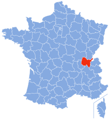
Savoie (Savoie)


- French department in the Auvergne-Rhône-Alpes region of the French Alps
 Hiking in Savoie
Savoie, located in the Auvergne-Rhône-Alpes region of France, is a stunning area known for its dramatic landscapes, alpine scenery, and rich cultural heritage. Hiking in Savoie offers a diverse range of trails suitable for all skill levels, from leisurely walks to challenging mountain treks.
Highlights of Hiking in Savoie
-
Diverse Terrain:
- The region features a variety of terrains, including rugged mountains, lush valleys, alpine lakes, and charming villages. This diversity makes it an ideal location for hikers looking for different experiences.
-
Mont Blanc Massif:
- One of the most iconic hiking areas is around Mont Blanc, the highest peak in the Alps. Trails like the Tour du Mont Blanc offer breathtaking views and challenging routes that attract hikers from all over the world.
-
Vanoise National Park:
- This park is a highlight for outdoor enthusiasts. It boasts an extensive network of marked trails that allow hikers to explore glaciers, meadows, and wildlife. The park is home to ibex, chamois, and various bird species.
-
Alpine Lakes:
- There are numerous beautiful alpine lakes in Savoie, such as Lac d’Annecy and Lac de la Sassière, which provide stunning backdrops for hiking and are perfect for a scenic picnic.
-
Charming Villages:
- The region is dotted with quaint villages like Albertville, Chambéry, and La Féclaz. These spots offer opportunities for cultural exploration, local cuisine, and a chance to experience the traditional Savoie lifestyle.
-
Local Cuisine:
- After a day of hiking, savor the local culinary delights. Try regional specialties such as fondue, raclette, tartiflette, and various cheeses.
Best Seasons for Hiking
- Summer (June to September): This is the most popular season for hiking in Savoie. The weather is generally mild, and most trails are accessible.
- Autumn (October): Early autumn offers beautiful fall foliage, although some higher trails may begin to close due to snow.
- Winter (December to March): While hiking is less common in winter, snowshoeing and winter hiking trails do exist in certain areas.
- Spring (April to May): Spring is a beautiful time to hike as wildflowers begin to bloom, but some trails at higher altitudes may still be snow-covered.
Safety Tips
- Prepare: Always check the weather forecast before your hike. Conditions can change rapidly in mountainous regions.
- Equipment: Wear sturdy hiking boots, and carry essentials such as water, snacks, a map or GPS, and appropriate clothing for changing weather conditions.
- Altitude: Be aware of altitude sickness if you plan to hike at high elevations.
- Stay on Marked Trails: To protect the natural environment and ensure your safety, stick to designated paths.
Hiking in Savoie offers breathtaking views and unforgettable experiences in the heart of the Alps. Whether you are looking for a day hike or a multi-day adventure, this region has it all!
- Country:

- Capital: Chambéry
- Coordinates: 45° 35' 0" N, 6° 20' 0" E


- GPS tracks (wikiloc): [Link]
- AboveSeaLevel: 1595 м m
- Area: 6028 sq km
- Population: 428204
- Web site: http://www.savoie.pref.gouv.fr/
- Wikipedia en: wiki(en)
- Wikipedia: wiki(fr)
- Wikidata storage: Wikidata: Q12745
- Wikipedia Commons Gallery: [Link]
- Wikipedia Commons Category: [Link]
- Wikipedia Commons Maps Category: [Link]
- Freebase ID: [/m/0m0d6]
- GeoNames ID: Alt: [2975517]
- SIREN number: [227300019]
- BnF ID: [12155663d]
- VIAF ID: Alt: [263099275]
- OSM relation ID: [7425]
- GND ID: Alt: [4118458-0]
- archINFORM location ID: [43]
- Library of Congress authority ID: Alt: [n80115811]
- PACTOLS thesaurus ID: [pcrtkbRpNqs3L7]
- MusicBrainz area ID: [e39bdfe9-7cfc-4b1d-8f29-ae63663c889a]
- Quora topic ID: [Savoya-1]
- TGN ID: [7002987]
- SUDOC authorities ID: [030065259]
- Encyclopædia Britannica Online ID: [place/Savoie]
- Twitter username: Alt: [SavoieDepart]
- DMOZ ID: Alt: [Regional/Europe/France/Regions/Rhone-Alpes/Savoie/]
- data.gouv.fr org ID: [conseil-departemental-de-savoie]
- YouTube channel ID: [UClz8i0_jW2wI3bBVE7vZuGg]
- NUTS code: [FR717]
- INSEE department code: [73]
- Foursquare venue ID: [51ebd4f0498e6b91f8686945]
- US National Archives Identifier: 10044290
- ISO 3166-2 code: FR-73
Includes regions:


Saint-Alban-d'Hurtières
- commune in Savoie, France
Hiking in Saint-Alban-d'Hurtières
Saint-Alban-d'Hurtières, located in the Savoie region of the French Alps, is a hidden gem for hiking enthusiasts. The area offers a mix of stunning mountain landscapes, lush forests, and diverse wildlife, making it suitable for hikers of all levels. Here are some highlights about hiking in this region:...
- Country:
- Postal Code: 73220
- Coordinates: 45° 29' 0" N, 6° 16' 35" E
- GPS tracks (wikiloc): [Link]
- Area: 19.4 sq km
- Population: 337


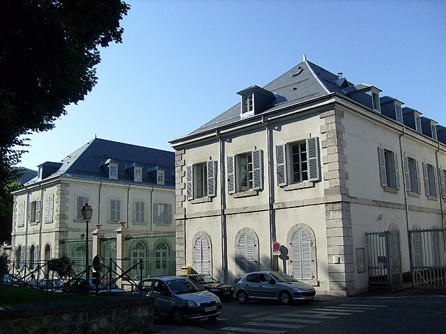
Chambéry
- commune in Savoie, France
Hiking in Chambéry
Chambéry, located in the Auvergne-Rhône-Alpes region of France, is surrounded by stunning mountains and beautiful landscapes, making it an excellent destination for hiking enthusiasts. Here are some highlights about hiking in the area:...
- Country:
- Postal Code: 73000
- Coordinates: 45° 33' 59" N, 5° 55' 15" E
- GPS tracks (wikiloc): [Link]
- AboveSeaLevel: 270 м m
- Area: 20.99 sq km
- Population: 59697
- Web site: [Link]


Saint-Offenge
- commune in Savoie, France
Hiking in Saint-Offenge
Saint-Offenge is a charming village located in the Auvergne-Rhône-Alpes region of France, surrounded by beautiful landscapes that are perfect for hiking enthusiasts. The area features a mix of rolling hills, forests, and scenic views of the surrounding mountains....
- Country:
- Postal Code: 73100
- Coordinates: 45° 44' 7" N, 6° 0' 8" E
- GPS tracks (wikiloc): [Link]
- Area: 7.92 sq km
- Population: 1043
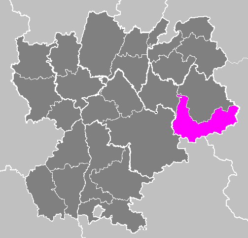

arrondissement of Saint-Jean-de-Maurienne
- arrondissement of France in the Savoie department
Hiking in arrondissement of Saint-Jean-de-Maurienne
The Arrondissement of Saint-Jean-de-Maurienne, located in the Savoie region of the French Alps, is an excellent destination for hiking enthusiasts. This area is renowned for its stunning mountainous landscapes, diverse trails, and rich cultural heritage. Here are some highlights and tips for hiking in this beautiful region:...
- Country:
- Capital: Saint-Jean-de-Maurienne
- Coordinates: 45° 10' 0" N, 6° 35' 0" E
- GPS tracks (wikiloc): [Link]
- Area: 1976 sq km
- Population: 43240


arrondissement of Albertville
- arrondissement of France
Hiking in arrondissement of Albertville
The Arrondissement of Albertville, located in the Savoie region of the French Alps, is a fantastic destination for hiking enthusiasts. Known for its stunning alpine landscape, the area offers a variety of trails suitable for different skill levels, from leisurely walks to more challenging treks....
- Country:
- Capital: Albertville
- Coordinates: 45° 35' 0" N, 6° 35' 0" E
- GPS tracks (wikiloc): [Link]
- Area: 2466 sq km
- Population: 111869


arrondissement of Chambéry
- arrondissement of France
Hiking in arrondissement of Chambéry
The Arrondissement of Chambéry, located in the Savoie department in the Auvergne-Rhône-Alpes region of southeastern France, is a fantastic area for hiking enthusiasts. Nestled in the French Alps, this region is characterized by stunning natural landscapes, including mountains, lakes, and lush valleys. Here are some highlights for hikers:...
- Country:
- Capital: Chambéry
- Coordinates: 45° 40' 0" N, 5° 55' 0" E
- GPS tracks (wikiloc): [Link]
- Area: 1586 sq km
- Population: 273095
Shares border with regions:

Piedmont
- region in North-West Italy
Hiking in Piedmont
Hiking in the Piedmont region offers a wonderful blend of natural beauty, diverse landscapes, and rich cultural heritage. This area, which generally encompasses the foothills of the Appalachian Mountains and stretches across parts of Virginia, North Carolina, South Carolina, and more, features rolling hills, lush forests, and scenic views. Here are some highlights and tips for hiking in Piedmont:...
- Country:

- Capital: Turin
- Coordinates: 45° 15' 0" N, 7° 55' 0" E
- GPS tracks (wikiloc): [Link]
- AboveSeaLevel: 421 м m
- Area: 25402 sq km
- Population: 4367559
- Web site: [Link]

Aosta Valley
- Italian mountainous semi-autonomous region in the North-West
Hiking in Aosta Valley
Aosta Valley, located in the northwest of Italy, is a mountainous region known for its stunning landscapes, rich history, and diverse outdoor activities, making it a paradise for hikers. Here’s a comprehensive overview of hiking in Aosta Valley:...
- Country:
- Capital: Aosta
- Postal Code: 11100, 11010-11029
- Licence Plate Code: AO
- Coordinates: 45° 43' 0" N, 7° 22' 0" E
- GPS tracks (wikiloc): [Link]
- AboveSeaLevel: 951 м m
- Area: 3263.22 sq km
- Population: 125901
- Web site: [Link]


Isère
- French department
Hiking in Isère
Isère, located in the Auvergne-Rhône-Alpes region of France, offers some of the most beautiful and diverse hiking opportunities in the French Alps. Known for its stunning mountain scenery, charming villages, and rich cultural heritage, Isère is a fantastic destination for hikers of all levels. Here are some highlights of hiking in Isère:...
- Country:
- Capital: Grenoble
- Coordinates: 45° 20' 0" N, 5° 30' 0" E
- GPS tracks (wikiloc): [Link]
- AboveSeaLevel: 846 м m
- Area: 7431 sq km
- Population: 1251060
- Web site: [Link]


Haute-Savoie
- French department
Hiking in Haute-Savoie
Haute-Savoie, located in the southeastern part of France, is a stunning region of the French Alps known for its breathtaking landscapes, picturesque villages, and a plethora of outdoor activities. Hiking is one of the most popular pursuits in this area, offering trails that cater to all experience levels and showcasing everything from serene lakes to rugged mountain peaks....
- Country:
- Capital: Annecy
- Coordinates: 46° 0' 0" N, 6° 20' 0" E
- GPS tracks (wikiloc): [Link]
- AboveSeaLevel: 1160 м m
- Area: 4388 sq km
- Population: 793938
- Web site: [Link]

Province of Turin
- former province of Italy (1847 to 2014), now Metropolitan City of Turin (Q18288162)
Hiking in Province of Turin
The Province of Turin, located in the Piedmont region of northwest Italy, offers a diverse range of hiking opportunities set against stunning mountainous backdrops, particularly in the Susa Valley and the nearby areas of the Alps....
- Country:
- Capital: Turin
- Postal Code: 10010–10099; 10121–10156
- Local Dialing Code: 0161; 0125; 0124; 0123; 0122; 0121; 011
- Licence Plate Code: TO
- Coordinates: 45° 4' 0" N, 7° 42' 0" E
- GPS tracks (wikiloc): [Link]
- Area: 6821 sq km
- Web site: [Link]

Ain
- French département
Hiking in Ain
Certainly! Ain, a department located in the Auvergne-Rhône-Alpes region of France, offers a diverse range of hiking opportunities, from gentle trails suited for families to more challenging hikes for experienced trekkers. Here are some highlights about hiking in Ain:...
- Country:
- Capital: Bourg-en-Bresse
- Coordinates: 46° 5' 0" N, 5° 20' 0" E
- GPS tracks (wikiloc): [Link]
- Area: 5762 sq km
- Population: 631877
- Web site: [Link]

Hautes-Alpes
- department in southeastern France named after the Alps mountain range
Hiking in Hautes-Alpes
The Hautes-Alpes region in southeastern France is a spectacular destination for hiking enthusiasts, known for its stunning landscapes, diverse terrain, and rich biodiversity. The region is part of the French Alps and offers a variety of hiking trails suitable for different skill levels....
- Country:
- Capital: Gap
- Coordinates: 44° 40' 0" N, 6° 20' 0" E
- GPS tracks (wikiloc): [Link]
- AboveSeaLevel: 1665 м m
- Area: 5549 sq km
- Population: 140916
- Web site: [Link]