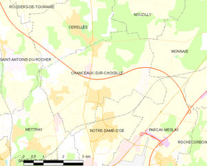
Chanceaux-sur-Choisille (Chanceaux-sur-Choisille)
- commune in Indre-et-Loire, France
- Country:

- Postal Code: 37390
- Coordinates: 47° 28' 15" N, 0° 42' 12" E


- GPS tracks (wikiloc): [Link]
- Area: 18.47 sq km
- Population: 3492
- Web site: http://www.chanceauxsurchoisille.fr
- Wikipedia en: wiki(en)
- Wikipedia: wiki(fr)
- Wikidata storage: Wikidata: Q745610
- Wikipedia Commons Category: [Link]
- Freebase ID: [/m/03nvcvm]
- GeoNames ID: Alt: [6448670]
- SIREN number: [213700545]
- BnF ID: [152576059]
- PACTOLS thesaurus ID: [pcrttYevlovkFc]
- Digital Atlas of the Roman Empire ID: [15648]
- Pleiades ID: [138286]
- INSEE municipality code: 37054
Shares border with regions:


Cerelles
- commune in Indre-et-Loire, France
- Country:

- Postal Code: 37390
- Coordinates: 47° 29' 58" N, 0° 40' 55" E


- GPS tracks (wikiloc): [Link]
- Area: 12.3 sq km
- Population: 1201


Saint-Antoine-du-Rocher
- commune in Indre-et-Loire, France
- Country:

- Postal Code: 37360
- Coordinates: 47° 29' 46" N, 0° 37' 48" E


- GPS tracks (wikiloc): [Link]
- Area: 24.23 sq km
- Population: 1704
- Web site: [Link]


Parçay-Meslay
- commune in Indre-et-Loire, France
- Country:

- Postal Code: 37210
- Coordinates: 47° 26' 30" N, 0° 44' 44" E


- GPS tracks (wikiloc): [Link]
- Area: 14.07 sq km
- Population: 2269
- Web site: [Link]


Monnaie
- commune in Indre-et-Loire, France
- Country:

- Postal Code: 37380
- Coordinates: 47° 30' 2" N, 0° 47' 7" E


- GPS tracks (wikiloc): [Link]
- Area: 39.42 sq km
- Population: 4298
- Web site: [Link]


Mettray
- commune in Indre-et-Loire, France
- Country:

- Postal Code: 37390
- Coordinates: 47° 27' 9" N, 0° 38' 54" E


- GPS tracks (wikiloc): [Link]
- Area: 10.34 sq km
- Population: 2031
- Web site: [Link]


Notre-Dame-d'Oé
- commune in Indre-et-Loire, France
- Country:

- Postal Code: 37390
- Coordinates: 47° 27' 28" N, 0° 42' 29" E


- GPS tracks (wikiloc): [Link]
- Area: 7.73 sq km
- Population: 4045
- Web site: [Link]


Nouzilly
- commune in Indre-et-Loire, France
- Country:

- Postal Code: 37380
- Coordinates: 47° 32' 36" N, 0° 44' 38" E


- GPS tracks (wikiloc): [Link]
- Area: 40.24 sq km
- Population: 1265
- Web site: [Link]
