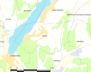
Charavines (Charavines)

- commune in Isère, France
 Hiking in Charavines
Charavines is a picturesque village located in the Isère department of the Auvergne-Rhône-Alpes region in southeastern France. Nestled near the shores of Lake Paladru, it offers a variety of hiking opportunities suitable for all levels of outdoor enthusiasts. Here are some highlights of hiking in and around Charavines:
Trails and Scenery
-
Lakeside Paths: The area around Lake Paladru features beautiful lakeside paths that allow hikers to enjoy stunning views of the water and surrounding mountains. These trails are generally easy and suitable for families.
-
Forest Trails: There are several forested hiking paths in the nearby hills, providing a serene atmosphere for those who enjoy the tranquility of nature. These trails often give you a chance to observe local wildlife and flora.
-
Panoramic Views: For those seeking a bit more of a challenge, trails that ascend into the surrounding foothills and mountains offer breathtaking panoramic views of the lake and the Savoie region. The hikes may be more strenuous but are rewarding.
-
Cultural Sites: Some trails may lead to nearby cultural and historical landmarks, such as old chapels or archaeological sites, allowing hikers to combine nature with a bit of history.
Tips for Hiking in Charavines
- Seasonal Considerations: The best times for hiking are typically spring through early fall when the weather is mild, and trails are clear of snow.
- Equipment: Make sure to wear comfortable hiking shoes, carry enough water, snacks, and consider sun protection during warmer months. A map or GPS device can also be helpful, especially for less-marked trails.
- Local Regulations: Respect local guidelines regarding wildlife and nature conservation. Stick to marked trails to minimize your impact on the environment.
- Local Expertise: If you’re unfamiliar with the area, consider joining guided hikes offered by local instructors or outdoor clubs.
Other Activities
In addition to hiking, the area is also great for swimming, kayaking, and picnicking by the lake, making it a beautiful destination for a full day of outdoor activities.
Overall, Charavines offers a mix of leisure and adventure, making it a great destination for hikers of all skill levels looking to explore the natural beauty of southeastern France.
- Country:

- Postal Code: 38850
- Coordinates: 45° 25' 50" N, 5° 30' 48" E


- GPS tracks (wikiloc): [Link]
- Area: 7.52 sq km
- Population: 1907
- Web site: http://www.mairie-charavines.fr
- Wikipedia en: wiki(en)
- Wikipedia: wiki(fr)
- Wikidata storage: Wikidata: Q1003033
- Wikipedia Commons Category: [Link]
- Freebase ID: [/m/03g_67f]
- GeoNames ID: Alt: [6448750]
- SIREN number: [213800824]
- BnF ID: [15257910q]
- VIAF ID: Alt: [239179985]
- WOEID: [584591]
- Encyclopædia Universalis ID: [charavines-prehistoire]
- INSEE municipality code: 38082
Shares border with regions:


Apprieu
- commune in Isère, France
Hiking in Apprieu
Apprieu is a charming commune located in the Isère department in the Auvergne-Rhône-Alpes region of southeastern France. This area offers various hiking opportunities, leveraging its picturesque landscapes and proximity to the foothills of the French Alps. Here are some key points for hiking in and around Apprieu:...
- Country:
- Postal Code: 38140
- Coordinates: 45° 24' 1" N, 5° 29' 28" E
- GPS tracks (wikiloc): [Link]
- Area: 15.09 sq km
- Population: 3269
- Web site: [Link]


Le Pin
- former commune in Isère, France
Hiking in Le Pin
Le Pin, located in the Isère department of the Auvergne-Rhône-Alpes region in France, offers beautiful hiking opportunities with picturesque landscapes and a variety of trails suited for different skill levels. Here are some insights into hiking in the area:...
- Country:
- Postal Code: 38730
- Coordinates: 45° 27' 24" N, 5° 30' 20" E
- GPS tracks (wikiloc): [Link]
- Area: 9.6 sq km
- Population: 1255
- Web site: [Link]


Oyeu
- commune in Isère, France
Hiking in Oyeu
Oyeu is a charming municipality located in the Auvergne-Rhône-Alpes region of France, known for its picturesque landscapes and outdoor activities, including hiking. Although Oyeu might not be as famous as some larger hiking destinations, it offers a range of trails that cater to various skill levels and preferences....
- Country:
- Postal Code: 38690
- Coordinates: 45° 25' 19" N, 5° 28' 28" E
- GPS tracks (wikiloc): [Link]
- Area: 13.69 sq km
- Population: 956
- Web site: [Link]

Bilieu
- commune in Isère, France
Hiking in Bilieu
Bilieu is a charming village located in the Auvergne-Rhône-Alpes region of France, near the shores of Lake Paladru. It offers a variety of hiking opportunities that cater to different skill levels, allowing both beginners and experienced hikers to explore the natural beauty of the area. Here are some highlights of hiking in Bilieu:...
- Country:
- Postal Code: 38850
- Coordinates: 45° 26' 55" N, 5° 32' 59" E
- GPS tracks (wikiloc): [Link]
- Area: 6.71 sq km
- Population: 1503
- Web site: [Link]


Chirens
- commune in Isère, France
Hiking in Chirens
Chirens is a charming village located in the Isère department in the Auvergne-Rhône-Alpes region of southeastern France. It’s surrounded by beautiful natural landscapes, making it a great destination for hiking enthusiasts. Here are some highlights for hiking in and around Chirens:...
- Country:
- Postal Code: 38850
- Coordinates: 45° 24' 50" N, 5° 33' 21" E
- GPS tracks (wikiloc): [Link]
- AboveSeaLevel: 876 м m
- Area: 17.53 sq km
- Population: 2342
- Web site: [Link]