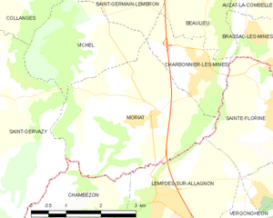
Charbonnier-les-Mines (Charbonnier-les-Mines)

- commune in Puy-de-Dôme, France
- Country:

- Postal Code: 63340
- Coordinates: 45° 25' 0" N, 3° 17' 6" E


- GPS tracks (wikiloc): [Link]
- Area: 3.36 sq km
- Population: 901
- Web site: http://63091.web63.fr
- Wikipedia en: wiki(en)
- Wikipedia: wiki(fr)
- Wikidata storage: Wikidata: Q242279
- Wikipedia Commons Category: [Link]
- Freebase ID: [/m/03qh8zh]
- GeoNames ID: Alt: [6613070]
- SIREN number: [216300913]
- BnF ID: [152694419]
- PACTOLS thesaurus ID: [pcrtqbwBodg9y4]
- INSEE municipality code: 63091
Shares border with regions:


Saint-Germain-Lembron
- commune in Puy-de-Dôme, France
- Country:
- Postal Code: 63340
- Coordinates: 45° 27' 29" N, 3° 14' 23" E
- GPS tracks (wikiloc): [Link]
- Area: 15.7 sq km
- Population: 1934


Beaulieu
- commune in Puy-de-Dôme, France
- Country:
- Postal Code: 63570
- Coordinates: 45° 26' 42" N, 3° 17' 8" E
- GPS tracks (wikiloc): [Link]
- Area: 8.65 sq km
- Population: 423


Sainte-Florine
- commune in Haute-Loire, France
- Country:
- Postal Code: 43250
- Coordinates: 45° 24' 19" N, 3° 19' 2" E
- GPS tracks (wikiloc): [Link]
- Area: 7.67 sq km
- Population: 3066
- Web site: [Link]


Brassac-les-Mines
- commune in Puy-de-Dôme, France
- Country:
- Postal Code: 63570
- Coordinates: 45° 24' 51" N, 3° 19' 44" E
- GPS tracks (wikiloc): [Link]
- Area: 7.2 sq km
- Population: 3300
- Web site: [Link]
Moriat
- commune in Puy-de-Dôme, France
- Country:
- Postal Code: 63340
- Coordinates: 45° 24' 18" N, 3° 15' 41" E
- GPS tracks (wikiloc): [Link]
- AboveSeaLevel: 460 м m
- Area: 10.81 sq km
- Population: 362