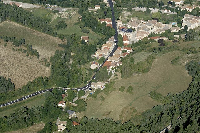
Charens (Charens)

- commune in Drôme, France
 Hiking in Charens
Charens is a relatively lesser-known destination for hiking enthusiasts, famous for its beautiful landscapes and diverse trails. Though it might not be as popular as some major hiking areas, it offers a unique experience for those looking to explore its natural beauty.
Hiking Trails:
-
Beginner Trails: Charens features several beginner-friendly trails that are well-marked and accessible. These trails often lead through scenic areas, allowing newcomers to enjoy the beauty of nature without overwhelming challenges.
-
Intermediate Trails: If you're looking for a bit of a challenge, there are intermediate trails that vary in length and terrain. Expect to encounter some elevation changes and more rugged paths that offer rewarding views.
-
Advanced Trails: For seasoned hikers, Charens has some advanced trails that can test your skills and endurance. These trails often take you through less-traveled areas, offering solitude as well as breathtaking vistas.
Nature and Wildlife: Hiking in Charens provides opportunities to observe local wildlife, including various bird species and small mammals. The region may feature diverse flora depending on the season, making it a great spot for nature photography.
Safety Tips:
- Always check the weather before heading out, as conditions can change quickly.
- Carry adequate water and snacks, as well as a first-aid kit.
- Make sure to wear appropriate footwear and clothing for the terrain and climate.
- Inform someone about your hiking plans, especially if you intend to go on less-trafficked trails.
Best Time to Hike: The best time for hiking in Charens is typically during the spring and fall when temperatures are mild and the scenery is particularly vibrant with blooming flowers or autumn foliage.
Getting There: Make sure you have detailed maps or a reliable GPS device, as some trails may not be well-marked. Familiarize yourself with parking options and trailheads to ensure a smooth start to your hiking adventure.
Overall, hiking in Charens can be a memorable experience filled with natural beauty and the chance to connect with the outdoors. Always remember to practice Leave No Trace principles to preserve the area's natural charm for future hikers.
- Country:

- Postal Code: 26310
- Coordinates: 44° 32' 18" N, 5° 30' 37" E


- GPS tracks (wikiloc): [Link]
- Area: 13.47 sq km
- Population: 28
- Wikipedia en: wiki(en)
- Wikipedia: wiki(fr)
- Wikidata storage: Wikidata: Q1060503
- Wikipedia Commons Category: [Link]
- Freebase ID: [/m/03mhfmf]
- GeoNames ID: Alt: [6453480]
- SIREN number: [212600761]
- BnF ID: [15252937j]
- INSEE municipality code: 26076
Shares border with regions:


Valdrôme
- commune in Drôme, France
Hiking in Valdrôme
Valdrôme is a picturesque village located in the Drôme department of the Auvergne-Rhône-Alpes region in southeastern France. It's known for its stunning natural scenery, which makes it a fantastic destination for hiking enthusiasts. Here are some details you might find helpful for planning a hiking trip there:...
- Country:
- Postal Code: 26310
- Coordinates: 44° 30' 15" N, 5° 34' 23" E
- GPS tracks (wikiloc): [Link]
- Area: 41.51 sq km
- Population: 147
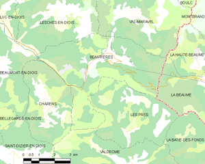
Beaurières
- commune in Drôme, France
Hiking in Beaurières
Beaurières is a beautiful destination located in the French Alps, known for its picturesque landscapes and diverse hiking opportunities. Set within the Drôme department, it offers hikers a chance to immerse themselves in nature, with stunning mountain views, serene lakes, and an abundance of flora and fauna....
- Country:
- Postal Code: 26310
- Coordinates: 44° 34' 18" N, 5° 33' 34" E
- GPS tracks (wikiloc): [Link]
- Area: 24.58 sq km
- Population: 80


Saint-Dizier-en-Diois
- commune in Drôme, France
Hiking in Saint-Dizier-en-Diois
Saint-Dizier-en-Diois is a charming commune located in the Drôme department of southeastern France, nestled in the picturesque landscapes of the Diois region. The area is well-known for its stunning natural beauty, making it an appealing destination for hiking enthusiasts....
- Country:
- Postal Code: 26310
- Coordinates: 44° 30' 51" N, 5° 28' 38" E
- GPS tracks (wikiloc): [Link]
- Area: 13.94 sq km
- Population: 47


Beaumont-en-Diois
- commune in Drôme, France
Hiking in Beaumont-en-Diois
Beaumont-en-Diois is a picturesque village located in the Drôme region of France, within the stunning Diois mountains. The area offers a variety of hiking opportunities, attracting both casual walkers and experienced hikers. Here’s what you can expect when hiking in and around Beaumont-en-Diois:...
- Country:
- Postal Code: 26310
- Coordinates: 44° 34' 14" N, 5° 28' 34" E
- GPS tracks (wikiloc): [Link]
- Area: 17.65 sq km
- Population: 99