Charnay (Charnay)

- commune in Doubs, France
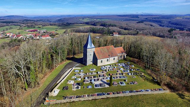
 Hiking in Charnay
Charnay, located in the Doubs department in the Bourgogne-Franche-Comté region of eastern France, is a picturesque area that offers a variety of hiking opportunities amidst beautiful landscapes.
Highlights of Hiking in Charnay, Doubs
-
Scenic Beauty: The region is characterized by stunning hills, lush forests, and panoramic views of the surrounding countryside. The diverse flora and fauna can be enjoyed along the trails.
-
Trail Variety: There are numerous hiking trails catering to different skill levels, from easy walks suitable for families to more challenging routes for experienced hikers. It's wise to check local maps or guidebooks for specific trails, as they can vary in difficulty.
-
Cultural Landmarks: While hiking, you may come across various historical sites and local architecture that reflect the rich history of the area. Be sure to take breaks to explore these points of interest.
-
Wildlife Observation: The Doubs region is rich in biodiversity. Hikers may have the chance to see a variety of wildlife, including birds, deer, and other local species, especially if they maintain a quiet demeanor.
-
Local Guides: Consider hiring a local guide who can provide insights into the natural and cultural history of the area, as well as ensure safety on the trails.
-
Weather Considerations: Be mindful of the weather, as conditions can change rapidly in the mountains. Always dress in layers, bring adequate water, and check local weather forecasts before heading out.
-
Nearby Attractions: After a day of hiking, you might want to explore nearby attractions such as local villages, markets, or even vineyards which can provide a taste of the regional culture and hospitality.
Tips for Hiking in Charnay
- Trail Maps: Acquire detailed maps from local tourist offices to help navigate the area efficiently.
- Safety Precautions: Inform someone about your hiking plans and estimated return time. Carry a first aid kit and ensure your phone is charged.
- Respect Nature: Follow “Leave No Trace” principles, stay on marked trails, and be respectful of wildlife.
Whether you're looking for a peaceful walk through nature or an adventurous hike, Charnay in Doubs offers a charming escape into the great outdoors.
- Country:

- Postal Code: 25440
- Coordinates: 47° 7' 39" N, 5° 57' 20" E


- GPS tracks (wikiloc): [Link]
- Area: 5.66 sq km
- Population: 478
- Wikipedia en: wiki(en)
- Wikipedia: wiki(fr)
- Wikidata storage: Wikidata: Q838852
- Wikipedia Commons Category: [Link]
- Freebase ID: [/m/03mgryd]
- Freebase ID: [/m/03mgryd]
- GeoNames ID: Alt: [6453840]
- GeoNames ID: Alt: [6453840]
- SIREN number: [212501266]
- SIREN number: [212501266]
- BnF ID: [15252352s]
- BnF ID: [15252352s]
- INSEE municipality code: 25126
- INSEE municipality code: 25126
Shares border with regions:


Palantine
- commune in Doubs, France
Hiking in Palantine
Palatine, a suburb of Chicago in Cook County, Illinois, offers a few options for hiking and enjoying the outdoors, though it might not be known for rugged terrain or extensive trails like some more mountainous areas. Here are some places you might consider for hiking and outdoor activities in and around Palatine:...
- Country:
- Postal Code: 25440
- Coordinates: 47° 5' 21" N, 5° 56' 36" E
- GPS tracks (wikiloc): [Link]
- Area: 4.31 sq km
- Population: 64


Chenecey-Buillon
- commune in Doubs, France
Hiking in Chenecey-Buillon
Chenecey-Buillon, located in the Doubs department of the Bourgogne-Franche-Comté region in France, offers a pleasant natural landscape for hiking enthusiasts. The area is characterized by its scenic countryside, rolling hills, and lush forests, making it a wonderful destination for outdoor activities....
- Country:
- Postal Code: 25440
- Coordinates: 47° 8' 24" N, 5° 57' 33" E
- GPS tracks (wikiloc): [Link]
- Area: 16.58 sq km
- Population: 527


Cessey
- commune in Doubs, France
Hiking in Cessey
Cessey is not widely recognized as a specific hiking destination, so it might be a small town or area that isn't heavily documented in hiking literature. However, if you're referring to a particular region or are looking for guidance on hiking in hiking-friendly areas near where "Cessey" might be located, I’d suggest considering a few general tips and information:...
- Country:
- Postal Code: 25440
- Coordinates: 47° 6' 31" N, 5° 54' 51" E
- GPS tracks (wikiloc): [Link]
- Area: 7.53 sq km
- Population: 340
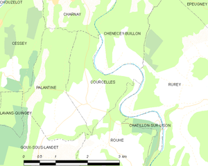
Courcelles
- commune in Doubs, France
Hiking in Courcelles
Courcelles, located in the Doubs department of the Bourgogne-Franche-Comté region in eastern France, is surrounded by beautiful natural landscapes that make it an appealing destination for hiking enthusiasts. Here are some highlights about hiking in and around Courcelles:...
- Country:
- Postal Code: 25440
- Coordinates: 47° 5' 38" N, 5° 57' 25" E
- GPS tracks (wikiloc): [Link]
- AboveSeaLevel: 360 м m
- Area: 3.61 sq km
- Population: 111