Chessy (Chessy)

- commune in Seine-et-Marne, France
- Country:

- Postal Code: 77700
- Coordinates: 48° 52' 49" N, 2° 45' 48" E


- GPS tracks (wikiloc): [Link]
- Area: 5.74 sq km
- Population: 5131
- Web site: http://www.chessy77.fr
- Wikipedia en: wiki(en)
- Wikipedia: wiki(fr)
- Wikidata storage: Wikidata: Q1076338
- Wikipedia Commons Category: [Link]
- Freebase ID: [/m/09kz0m]
- Freebase ID: [/m/09kz0m]
- GeoNames ID: Alt: [6443606]
- GeoNames ID: Alt: [6443606]
- SIREN number: [217701119]
- SIREN number: [217701119]
- BnF ID: [152754526]
- BnF ID: [152754526]
- archINFORM location ID: [42109]
- archINFORM location ID: [42109]
- PACTOLS thesaurus ID: [pcrtaZAhPWm4ge]
- PACTOLS thesaurus ID: [pcrtaZAhPWm4ge]
- MusicBrainz area ID: [ac64a4bd-df2a-46b7-a108-405bb6ffbd30]
- MusicBrainz area ID: [ac64a4bd-df2a-46b7-a108-405bb6ffbd30]
- INSEE municipality code: 77111
- INSEE municipality code: 77111
Shares border with regions:

Chalifert
- commune in Seine-et-Marne, France
- Country:
- Postal Code: 77144
- Coordinates: 48° 53' 19" N, 2° 46' 23" E
- GPS tracks (wikiloc): [Link]
- Area: 2.42 sq km
- Population: 1270
- Web site: [Link]


Serris
- commune in Seine-et-Marne, France
- Country:
- Postal Code: 77700
- Coordinates: 48° 51' 23" N, 2° 47' 10" E
- GPS tracks (wikiloc): [Link]
- Area: 5.65 sq km
- Population: 8621
- Web site: [Link]

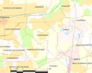
Montévrain
- commune in Seine-et-Marne, France
- Country:
- Postal Code: 77144
- Coordinates: 48° 52' 31" N, 2° 44' 44" E
- GPS tracks (wikiloc): [Link]
- Area: 5.45 sq km
- Population: 10337
- Web site: [Link]


Dampmart
- commune in Seine-et-Marne, France
- Country:
- Postal Code: 77400
- Coordinates: 48° 53' 12" N, 2° 44' 6" E
- GPS tracks (wikiloc): [Link]
- Area: 5.92 sq km
- Population: 3309
- Web site: [Link]


Coupvray
- commune in Seine-et-Marne, France
- Country:
- Postal Code: 77700
- Coordinates: 48° 53' 31" N, 2° 47' 37" E
- GPS tracks (wikiloc): [Link]
- Area: 8.09 sq km
- Population: 2811
- Web site: [Link]