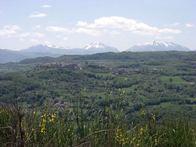
Chiaromonte (Chiaromonte)
.svg)
- Italian comune
 Hiking in Chiaromonte
Chiaromonte is a charming hilltop town located in the Basilicata region of southern Italy, and it offers some fantastic opportunities for hiking. Here are some key points about hiking in and around Chiaromonte:
Scenic Trails
-
Local Nature Trails: The surrounding landscapes are characterized by rolling hills, rugged terrain, and beautiful vistas. There are several trails suitable for various skill levels, allowing hikers to experience the natural beauty of the region.
-
Sila National Park: A bit further afield, the Sila National Park offers numerous hiking trails through dense forests, past lakes, and up to panoramic viewpoints. It’s an excellent option for those wanting to explore more extensive wilderness areas.
-
Historical Routes: Some trails near Chiaromonte lead to ancient ruins and historical sites, making a hike both a physical and cultural experience.
Flora and Fauna
- The region is rich in biodiversity, with various plant species and wildlife. Keep an eye out for local fauna, including birds, deer, and perhaps even some rare species.
Preparation
- Gear: Ensure you have comfortable hiking boots, water, snacks, and a map or GPS device, as some trails may not be well-marked.
- Weather: Check the local weather conditions before heading out, as they can change rapidly.
Local Insights
- Guided Tours: If you prefer to explore with a guide, consider joining local hiking tours which can provide insights into the area’s history and ecology.
- Community Events: Occasionally, there are local hiking events or festivals that promote outdoor activities and community participation.
Accessibility
- Chiaromonte is accessible from other cities in Basilicata, such as Potenza and Matera, making it a convenient stop for hikers exploring the region.
Overall, hiking in Chiaromonte offers a blend of scenic beauty, cultural exploration, and the chance to experience the tranquility of the Italian countryside. Make sure to take your time and enjoy the stunning landscapes that this hidden gem has to offer!
- Country:

- Postal Code: 85032
- Local Dialing Code: 0973
- Licence Plate Code: PZ
- Coordinates: 40° 7' 0" N, 16° 13' 0" E


- GPS tracks (wikiloc): [Link]
- AboveSeaLevel: 794 м m
- Area: 70.02 sq km
- Population: 1922
- Web site: http://www.comune.chiaromonte.pz.it
- Wikipedia en: wiki(en)
- Wikipedia: wiki(it)
- Wikidata storage: Wikidata: Q52561
- Wikipedia Commons Category: [Link]
- Freebase ID: [/m/0fh390]
- GeoNames ID: Alt: [6538997]
- VIAF ID: Alt: [144696046]
- OSM relation ID: [40140]
- UN/LOCODE: [ITIT4]
- Digital Atlas of the Roman Empire ID: [30444]
- ISTAT ID: 076028
- Italian cadastre code: C619
Shares border with regions:
Castronuovo di Sant'Andrea
- Italian comune
Hiking in Castronuovo di Sant'Andrea
Castronuovo di Sant'Andrea is a small village located in the Basilicata region of southern Italy, surrounded by the picturesque Apennine Mountains. This area offers some beautiful hiking opportunities, with trails that showcase the natural beauty and rugged landscapes of the region....
- Country:
- Postal Code: 85030
- Local Dialing Code: 0973
- Licence Plate Code: PZ
- Coordinates: 40° 11' 0" N, 16° 11' 0" E
- GPS tracks (wikiloc): [Link]
- AboveSeaLevel: 650 м m
- Area: 47.45 sq km
- Population: 1016
- Web site: [Link]
Episcopia
- Italian comune
Hiking in Episcopia
Episcopia, a charming town in the Basilicata region of southern Italy, is not as well-known for hiking as some other areas in the country, but it offers some beautiful landscapes and trails that are perfect for outdoor enthusiasts. The region is characterized by its rolling hills, lush greenery, and scenic views of the surrounding countryside....
- Country:
- Postal Code: 85033
- Local Dialing Code: 0973
- Licence Plate Code: PZ
- Coordinates: 40° 4' 29" N, 16° 5' 53" E
- GPS tracks (wikiloc): [Link]
- AboveSeaLevel: 530 м m
- Area: 28.64 sq km
- Population: 1389
- Web site: [Link]
Fardella, Basilicata
- Italian comune
Hiking in Fardella, Basilicata
Fardella is a small village in the Basilicata region of Italy, known for its picturesque landscapes and natural beauty, making it an ideal spot for hiking enthusiasts. Here are some key highlights and tips for hiking in and around Fardella:...
- Country:
- Postal Code: 85030
- Local Dialing Code: 0973
- Licence Plate Code: PZ
- Coordinates: 40° 7' 0" N, 16° 10' 0" E
- GPS tracks (wikiloc): [Link]
- AboveSeaLevel: 745 м m
- Area: 29.08 sq km
- Population: 631
- Web site: [Link]
Francavilla in Sinni
- Italian comune
Hiking in Francavilla in Sinni
Francavilla in Sinni, located in the Basilicata region of southern Italy, offers a variety of hiking opportunities for outdoor enthusiasts. Nestled in a beautiful natural landscape, it serves as a gateway to the surrounding areas, including the Pollino National Park....
- Country:
- Postal Code: 85034
- Local Dialing Code: 0973
- Licence Plate Code: PZ
- Coordinates: 40° 5' 0" N, 16° 12' 0" E
- GPS tracks (wikiloc): [Link]
- AboveSeaLevel: 421 м m
- Area: 46.82 sq km
- Population: 4158
- Web site: [Link]
Noepoli
- Italian comune
Hiking in Noepoli
Noepoli is a small town located in the southern part of Italy, specifically in the Basilicata region. While it may not be as widely known for hiking as some other areas in Italy, it does offer opportunities for outdoor enthusiasts looking to explore the natural beauty of the region....
- Country:
- Postal Code: 85035
- Local Dialing Code: 0973
- Licence Plate Code: PZ
- Coordinates: 40° 5' 0" N, 16° 20' 0" E
- GPS tracks (wikiloc): [Link]
- AboveSeaLevel: 676 м m
- Area: 46.71 sq km
- Population: 841
- Web site: [Link]
Roccanova
- Italian comune
Hiking in Roccanova
Roccanova is a charming destination located in the Basilicata region of southern Italy. Nestled in the Apennine Mountains, it offers a range of hiking opportunities for outdoor enthusiasts. Here’s a guide to help you explore the hiking options in and around Roccanova:...
- Country:
- Postal Code: 85036
- Local Dialing Code: 0973
- Licence Plate Code: PZ
- Coordinates: 40° 13' 0" N, 16° 12' 0" E
- GPS tracks (wikiloc): [Link]
- AboveSeaLevel: 648 м m
- Area: 61.74 sq km
- Population: 1477
- Web site: [Link]


San Costantino Albanese
- Italian comune
Hiking in San Costantino Albanese
San Costantino Albanese is a charming village located in the Basilicata region of southern Italy. It sits in the Pollino National Park, which offers stunning landscapes and diverse ecosystems, making it an excellent destination for hiking enthusiasts....
- Country:
- Postal Code: 85030
- Local Dialing Code: 0973
- Licence Plate Code: PZ
- Coordinates: 40° 2' 0" N, 16° 18' 0" E
- GPS tracks (wikiloc): [Link]
- AboveSeaLevel: 650 м m
- Area: 43.25 sq km
- Population: 686
- Web site: [Link]
San Severino Lucano
- Italian comune
Hiking in San Severino Lucano
San Severino Lucano, located in the heart of the Basilicata region in southern Italy, is a wonderful destination for hiking enthusiasts. Nestled in the Pollino National Park, this area is known for its stunning natural landscapes, rich biodiversity, and a variety of trails suitable for different skill levels....
- Country:
- Postal Code: 85030
- Local Dialing Code: 0973
- Licence Plate Code: PZ
- Coordinates: 40° 1' 0" N, 16° 8' 0" E
- GPS tracks (wikiloc): [Link]
- AboveSeaLevel: 877 м m
- Area: 61.16 sq km
- Population: 1518
- Web site: [Link]
Senise
- Italian comune
Hiking in Senise
Senise, a charming town located in the Basilicata region of Italy, offers an array of hiking opportunities in a stunning natural environment. The surrounding area is characterized by rolling hills, lush forests, and breathtaking views. Here are some highlights and suggestions for hiking in Senise:...
- Country:
- Postal Code: 85038
- Local Dialing Code: 0973
- Licence Plate Code: PZ
- Coordinates: 40° 8' 0" N, 16° 17' 0" E
- GPS tracks (wikiloc): [Link]
- AboveSeaLevel: 335 м m
- Area: 97.31 sq km
- Population: 6995
- Web site: [Link]

Teana
- Italian comune
Hiking in Teana
Teana, located in the region of Calabria in southern Italy, offers beautiful landscapes and a variety of hiking opportunities. The area is known for its natural beauty, featuring mountains, forests, and picturesque views of the surrounding valleys and the Tyrrhenian Sea. Here are some key points to consider when hiking in Teana:...
- Country:
- Postal Code: 85030
- Local Dialing Code: 0973
- Licence Plate Code: PZ
- Coordinates: 40° 7' 40" N, 16° 9' 19" E
- GPS tracks (wikiloc): [Link]
- AboveSeaLevel: 806 м m
- Area: 19.3 sq km
- Population: 585
- Web site: [Link]
Terranova di Pollino
- Italian comune
Hiking in Terranova di Pollino
Terranova di Pollino, located in the Pollino National Park in southern Italy, is a fantastic destination for hiking enthusiasts. The park is known for its stunning landscapes, diverse flora and fauna, and significant geological formations. Here are some key highlights about hiking in this area:...
- Country:
- Postal Code: 85030
- Local Dialing Code: 0973
- Licence Plate Code: PZ
- Coordinates: 39° 59' 0" N, 16° 18' 0" E
- GPS tracks (wikiloc): [Link]
- AboveSeaLevel: 926 м m
- Area: 113.07 sq km
- Population: 1141
- Web site: [Link]
Viggianello
- Italian comune
Hiking in Viggianello
Viggianello is a charming village located in the heart of the Pollino National Park in Calabria, southern Italy. It offers a wonderful mix of natural beauty, cultural heritage, and outdoor activities, making it a great destination for hiking enthusiasts....
- Country:
- Postal Code: 85040
- Local Dialing Code: 0973
- Licence Plate Code: PZ
- Coordinates: 39° 58' 0" N, 16° 5' 0" E
- GPS tracks (wikiloc): [Link]
- AboveSeaLevel: 549 м m
- Area: 120.83 sq km
- Population: 2940
- Web site: [Link]


Castrovillari
- Italian comune
Hiking in Castrovillari
Castrovillari, a charming town in the Calabria region of southern Italy, is surrounded by stunning natural landscapes and offers excellent hiking opportunities. Situated near the Pollino National Park, the area is known for its rich biodiversity, scenic views, and various hiking trails that cater to different skill levels....
- Country:
- Postal Code: 87012
- Local Dialing Code: 0981
- Licence Plate Code: CS
- Coordinates: 39° 49' 0" N, 16° 12' 0" E
- GPS tracks (wikiloc): [Link]
- AboveSeaLevel: 362 м m
- Area: 130.64 sq km
- Population: 22037
- Web site: [Link]


Morano Calabro
- Italian comune
Hiking in Morano Calabro
Morano Calabro is a picturesque hilltop village in Calabria, Italy, known for its medieval architecture and stunning natural surroundings. It's an excellent destination for hiking enthusiasts due to the variety of trails and the beautiful landscapes that the region offers....
- Country:
- Postal Code: 87016
- Local Dialing Code: 0981
- Licence Plate Code: CS
- Coordinates: 39° 51' 0" N, 16° 8' 0" E
- GPS tracks (wikiloc): [Link]
- AboveSeaLevel: 694 м m
- Area: 116.26 sq km
- Population: 4413
- Web site: [Link]