Chitray (Chitray)

- commune in Indre, France
- Country:

- Postal Code: 36800
- Coordinates: 46° 38' 8" N, 1° 21' 32" E


- GPS tracks (wikiloc): [Link]
- Area: 19.94 sq km
- Population: 176
- Wikipedia en: wiki(en)
- Wikipedia: wiki(fr)
- Wikidata storage: Wikidata: Q626442
- Wikipedia Commons Category: [Link]
- Freebase ID: [/m/03nvbq5]
- GeoNames ID: Alt: [6448595]
- SIREN number: [213600513]
- BnF ID: [152573551]
- INSEE municipality code: 36051
Shares border with regions:


Oulches
- commune in Indre, France
- Country:
- Postal Code: 36800
- Coordinates: 46° 36' 55" N, 1° 17' 50" E
- GPS tracks (wikiloc): [Link]
- Area: 43.36 sq km
- Population: 407


Migné
- commune in Indre, France
- Country:
- Postal Code: 36800
- Coordinates: 46° 43' 0" N, 1° 19' 1" E
- GPS tracks (wikiloc): [Link]
- Area: 56.32 sq km
- Population: 278


Nuret-le-Ferron
- commune in Indre, France
- Country:
- Postal Code: 36800
- Coordinates: 46° 41' 3" N, 1° 25' 59" E
- GPS tracks (wikiloc): [Link]
- Area: 47.29 sq km
- Population: 311


Rivarennes
- commune in Indre, France
- Country:
- Postal Code: 36800
- Coordinates: 46° 38' 8" N, 1° 23' 8" E
- GPS tracks (wikiloc): [Link]
- Area: 37.41 sq km
- Population: 571

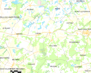
Ciron
- commune in Indre, France
- Country:
- Postal Code: 36300
- Coordinates: 46° 37' 38" N, 1° 14' 42" E
- GPS tracks (wikiloc): [Link]
- Area: 57.94 sq km
- Population: 562