Chiusa di Pesio (Chiusa di Pesio)
- Italian comune
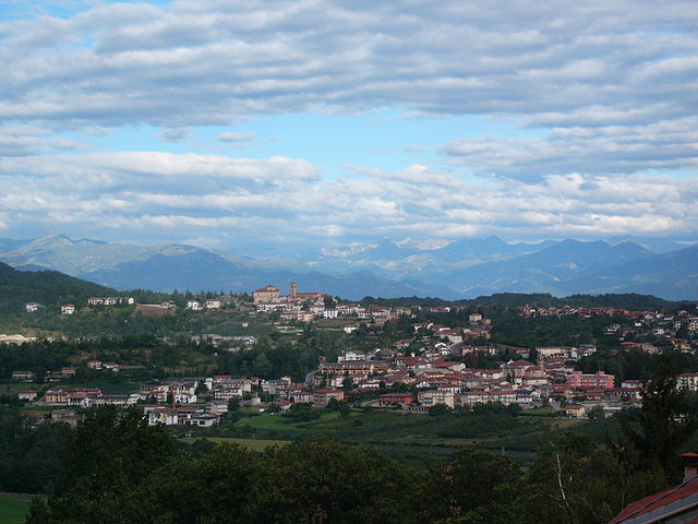
Chiusa di Pesio is a beautiful area located in the Piedmont region of Italy, renowned for its stunning natural landscapes and excellent hiking opportunities. Nestled in the heart of the Maritime Alps, Chiusa di Pesio offers a variety of trails that cater to different skill levels, making it an appealing destination for both casual walkers and experienced hikers.
Highlights of Hiking in Chiusa di Pesio:
-
Natural Park: The area is part of the Marguareis Natural Park, which features diverse flora and fauna, scenic views, and pristine mountain environments. The park is home to many species of wildlife, including deer, chamois, and various bird species.
-
Trail Diversity: There are numerous trails ranging from easy walks suitable for families to more challenging hikes that lead to higher elevations. Some popular trails include:
- Sentiero delle Marmotte: A moderately difficult trail that offers stunning views and the chance to see marmots in their natural habitat.
- Trail to Monte Marguareis: For veteran hikers, this trail leads to one of the highest peaks in the area, offering breathtaking panoramic views.
-
Cultural Sites: Along with the natural beauty, you can encounter historical and cultural sites. The area has several chapels and monuments that reflect the rich history of the region.
-
Flora and Fauna: The biodiversity in Chiusa di Pesio is impressive, with various plant species, wildflowers, and unique ecosystems. Spring and summer are particularly vibrant times to hike as the mountains bloom with a kaleidoscope of colors.
-
Accessibility: The main trailheads are easily accessible from the town of Chiusa di Pesio, and there are various parking options available. Local maps and information can often be found in tourist offices.
-
Local Amenities: The town has several accommodations, ranging from hotels to guesthouses, as well as eateries where you can enjoy traditional Piedmontese cuisine after a day of hiking.
-
Seasonal Considerations: Hiking is popular in the warmer months, but the trails can also offer winter sports opportunities such as snowshoeing and cross-country skiing. Always check weather conditions and trail availability before heading out, especially in winter.
Tips for Hiking in Chiusa di Pesio:
- Stay Hydrated: Bring plenty of water, especially on warmer days.
- Wear Appropriate Footwear: Sturdy hiking boots with good grip are essential due to varying terrain.
- Pack Essentials: Include a map, compass, first-aid kit, snacks, and weather-appropriate clothing.
- Respect Nature: Follow the Leave No Trace principles to minimize your impact on the environment.
Whether you're looking for a peaceful walk among the trees or a challenging climb to breathtaking viewpoints, Chiusa di Pesio has something to offer every hiking enthusiast. Enjoy your adventure!
- Country:

- Postal Code: 12013
- Local Dialing Code: 0171
- Licence Plate Code: CN
- Coordinates: 44° 19' 0" N, 7° 41' 0" E


- GPS tracks (wikiloc): [Link]
- AboveSeaLevel: 575 м m
- Area: 95.02 sq km
- Population: 3653
- Web site: http://www.comune.chiusasclafani.pa.it
- Wikipedia en: wiki(en)
- Wikipedia: wiki(it)
- Wikidata storage: Wikidata: Q19948
- Wikipedia Commons Category: [Link]
- Freebase ID: [/m/0gb956]
- GeoNames ID: Alt: [6541454]
- VIAF ID: Alt: [237490615]
- OSM relation ID: [42927]
- ISTAT ID: 004068
- Italian cadastre code: C653
Shares border with regions:

Beinette
- Italian comune
Beinette is a charming commune located in the Piedmont region of Italy, near the larger city of Cuneo. The surrounding area offers beautiful landscapes and opportunities for hiking, making it a great destination for outdoor enthusiasts....
- Country:

- Postal Code: 12081
- Local Dialing Code: 0171
- Licence Plate Code: CN
- Coordinates: 44° 22' 0" N, 7° 39' 0" E


- GPS tracks (wikiloc): [Link]
- AboveSeaLevel: 491 м m
- Area: 17.69 sq km
- Population: 3460
- Web site: [Link]

Briga Alta
- Italian comune
Briga Alta is a charming town located in the Piedmont region of northern Italy, known for its beautiful landscapes, historical significance, and excellent hiking opportunities. If you're considering hiking in that area, here are some details to keep in mind:...
- Country:

- Postal Code: 18025
- Local Dialing Code: 0174
- Licence Plate Code: CN
- Coordinates: 44° 4' 53" N, 7° 44' 27" E


- GPS tracks (wikiloc): [Link]
- AboveSeaLevel: 1310 м m
- Area: 52.18 sq km
- Population: 40
- Web site: [Link]

Limone Piemonte
- comune in Italy
Limone Piemonte is a charming alpine resort located in the Piedmont region of Italy, nestled in the Maritime Alps, near the border with France. It offers a range of hiking opportunities that cater to different skill levels, from casual walks to more challenging treks. Here are some key highlights about hiking in Limone Piemonte:...
- Country:

- Postal Code: 12015
- Local Dialing Code: 0171
- Licence Plate Code: CN
- Coordinates: 44° 12' 0" N, 7° 34' 0" E


- GPS tracks (wikiloc): [Link]
- AboveSeaLevel: 1010 м m
- Area: 70.81 sq km
- Population: 1466
- Web site: [Link]

Margarita
- Italian comune
Margarita, located in the Piedmont region of Italy, is known for its beautiful landscapes, rich history, and charming towns. Hiking in this area can be a delightful experience due to its diverse terrain, including rolling hills, vineyards, and scenic views of the Alps. Here are some highlights and tips for hiking in and around Margarita:...
- Country:

- Postal Code: 12040
- Local Dialing Code: 0171
- Licence Plate Code: CN
- Coordinates: 44° 24' 0" N, 7° 41' 0" E


- GPS tracks (wikiloc): [Link]
- AboveSeaLevel: 448 м m
- Area: 11.38 sq km
- Population: 1416
- Web site: [Link]

Peveragno
- Italian comune
Peveragno is a charming village located in the Piedmont region of Italy, close to the Cuneo province and nestled in a picturesque setting at the base of the Alps. It offers numerous hiking opportunities, showcasing stunning landscapes, rich biodiversity, and cultural landmarks. Here’s what you need to know about hiking in the area:...
- Country:

- Postal Code: 12016
- Local Dialing Code: 0171
- Licence Plate Code: CN
- Coordinates: 44° 20' 0" N, 7° 37' 0" E


- GPS tracks (wikiloc): [Link]
- AboveSeaLevel: 575 м m
- Area: 67.92 sq km
- Population: 5561
- Web site: [Link]
Pianfei
- Italian comune
Pianfei is a charming village located in the Piedmont region of Italy, surrounded by picturesque landscapes that make it a great destination for hiking enthusiasts. The area offers a variety of trails, catering to different skill levels and providing access to stunning views, rolling hills, and lush forests....
- Country:

- Postal Code: 12080
- Local Dialing Code: 0174
- Licence Plate Code: CN
- Coordinates: 44° 22' 22" N, 7° 42' 45" E


- GPS tracks (wikiloc): [Link]
- AboveSeaLevel: 500 м m
- Area: 15.31 sq km
- Population: 2129
- Web site: [Link]

Roccaforte Mondovì
- Italian comune
Roccaforte Mondovì is a charming village nestled in the Piedmont region of Italy, surrounded by the stunning landscape of the Maritime Alps. This area is known for its diverse hiking opportunities, offering trails for various skill levels and preferences. Here are some highlights and tips for hiking in Roccaforte Mondovì:...
- Country:

- Postal Code: 12088
- Local Dialing Code: 0174
- Licence Plate Code: CN
- Coordinates: 44° 19' 0" N, 7° 45' 0" E


- GPS tracks (wikiloc): [Link]
- AboveSeaLevel: 574 м m
- Area: 84.61 sq km
- Population: 2140
- Web site: [Link]

Villanova Mondovì
- Italian comune
Villanova Mondovì, located in the Piedmont region of Italy, is a charming town surrounded by beautiful landscapes and offers a range of hiking opportunities. The area is characterized by its rolling hills, valleys, and stunning views of the surrounding mountains, making it a fantastic destination for outdoor enthusiasts....
- Country:

- Postal Code: 12089
- Local Dialing Code: 0174
- Licence Plate Code: CN
- Coordinates: 44° 21' 0" N, 7° 46' 0" E


- GPS tracks (wikiloc): [Link]
- AboveSeaLevel: 526 м m
- Area: 28.29 sq km
- Population: 5795
- Web site: [Link]


La Brigue
- commune in Alpes-Maritimes, France
La Brigue is a beautiful commune in the Alpes-Maritimes department of southeastern France, located near the Italian border. Nestled in the Mercantour National Park, it offers stunning landscapes, diverse flora and fauna, and various hiking trails suitable for all levels of hikers. Here are some highlights about hiking in La Brigue:...
- Country:

- Postal Code: 06430
- Coordinates: 44° 3' 45" N, 7° 36' 59" E


- GPS tracks (wikiloc): [Link]
- AboveSeaLevel: 748 м m
- Area: 91.77 sq km
- Population: 706
- Web site: [Link]
