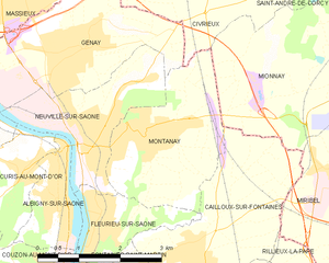
Civrieux (Civrieux)
- commune in Ain, France
- Country:

- Postal Code: 01390
- Coordinates: 45° 55' 16" N, 4° 52' 51" E


- GPS tracks (wikiloc): [Link]
- Area: 19.76 sq km
- Population: 1546
- Web site: http://mairie-civrieux01.fr
- Wikipedia en: wiki(en)
- Wikipedia: wiki(fr)
- Wikidata storage: Wikidata: Q604499
- Wikipedia Commons Category: [Link]
- Wikipedia Commons Maps Category: [Link]
- Freebase ID: [/m/03cz0tl]
- Freebase ID: [/m/03cz0tl]
- Freebase ID: [/m/03cz0tl]
- GeoNames ID: Alt: [6453497]
- GeoNames ID: Alt: [6453497]
- GeoNames ID: Alt: [6453497]
- SIREN number: [210101051]
- SIREN number: [210101051]
- SIREN number: [210101051]
- PACTOLS thesaurus ID: [pcrtYwdYOQvevq]
- PACTOLS thesaurus ID: [pcrtYwdYOQvevq]
- PACTOLS thesaurus ID: [pcrtYwdYOQvevq]
- INSEE municipality code: 01105
- INSEE municipality code: 01105
- INSEE municipality code: 01105
Shares border with regions:


Montanay
- commune in the metropolis of Lyon, France
- Country:

- Postal Code: 69250
- Coordinates: 45° 52' 45" N, 4° 51' 47" E


- GPS tracks (wikiloc): [Link]
- Area: 7.16 sq km
- Population: 3089
- Web site: [Link]

Mionnay
- commune in Ain, France
- Country:

- Postal Code: 01390
- Coordinates: 45° 53' 42" N, 4° 55' 47" E


- GPS tracks (wikiloc): [Link]
- Area: 19.62 sq km
- Population: 2138
- Web site: [Link]

Massieux
- commune in Ain, France
- Country:

- Postal Code: 01600
- Coordinates: 45° 54' 31" N, 4° 49' 49" E


- GPS tracks (wikiloc): [Link]
- Area: 3.1 sq km
- Population: 2516
- Web site: [Link]

Monthieux
- commune in Ain, France
- Country:

- Postal Code: 01390
- Coordinates: 45° 57' 26" N, 4° 56' 25" E


- GPS tracks (wikiloc): [Link]
- Area: 10.75 sq km
- Population: 651
- Web site: [Link]

Genay, Rhône
- commune in the metropolis of Lyon, France
- Country:

- Postal Code: 69730
- Coordinates: 45° 53' 49" N, 4° 50' 27" E


- GPS tracks (wikiloc): [Link]
- Area: 8.49 sq km
- Population: 5419
- Web site: [Link]

Saint-Jean-de-Thurigneux
- commune in Ain, France
- Country:

- Postal Code: 01390
- Coordinates: 45° 57' 8" N, 4° 52' 56" E


- GPS tracks (wikiloc): [Link]
- Area: 16 sq km
- Population: 778
- Web site: [Link]

Reyrieux
- commune in Ain, France
- Country:

- Postal Code: 01600
- Coordinates: 45° 56' 4" N, 4° 49' 24" E


- GPS tracks (wikiloc): [Link]
- Area: 15.7 sq km
- Population: 4544
- Web site: [Link]

Saint-André-de-Corcy
- commune in Ain, France
- Country:

- Postal Code: 01390
- Coordinates: 45° 55' 35" N, 4° 57' 8" E


- GPS tracks (wikiloc): [Link]
- Area: 20.73 sq km
- Population: 3129
- Web site: [Link]

Parcieux
- commune in Ain, France
- Country:

- Postal Code: 01600
- Coordinates: 45° 54' 56" N, 4° 49' 31" E


- GPS tracks (wikiloc): [Link]
- Area: 3.14 sq km
- Population: 1171
- Web site: [Link]