Clarafond-Arcine (Clarafond-Arcine)
- commune in Haute-Savoie, France
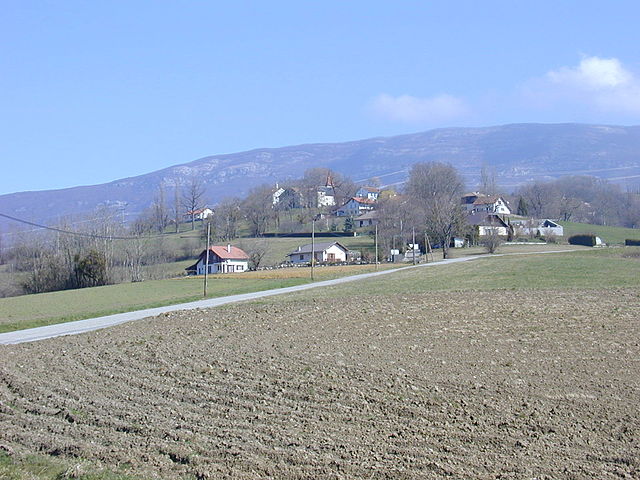
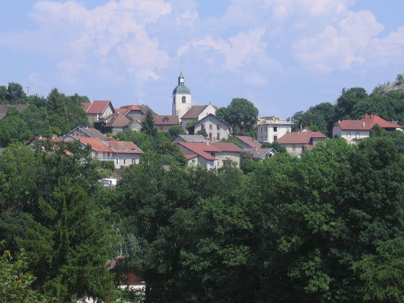
Clarafond-Arcine, a picturesque commune located in the Auvergne-Rhône-Alpes region of France, near Annecy, offers some beautiful hiking opportunities. The area is known for its stunning alpine scenery, encompassing rolling hills, lush forests, and panoramic views of the surrounding mountains.
Here are some key points about hiking in Clarafond-Arcine:
Hiking Trails
-
Varied Terrain: The hiking trails range in difficulty, with options suitable for beginners to more experienced hikers. You can find well-marked paths that wind through beautiful landscapes.
-
Scenic Routes: Some popular routes may take you through charming villages, past lakes, and along rivers, providing a great opportunity to appreciate the natural beauty of the area.
-
Alpine Views: Many trails offer breathtaking views of the nearby Mont Blanc range and the surrounding Alps, particularly as you gain elevation.
-
Flora and Fauna: The area is rich in biodiversity, and hikers may encounter a variety of wildlife and plant species native to the Alps.
Best Times to Hike
- Spring and Summer: Late spring to summer (from May to September) is ideal for hiking, as the weather is generally warm and trails are often accessible.
- Autumn: Early autumn can also be beautiful, with fall colors in the foliage.
Essential Tips
- Equipment: Wear sturdy hiking boots and consider trekking poles if you plan on tackling steeper trails. A good backpack with water and snacks is also essential.
- Navigation: While many trails are well-marked, it's a good idea to carry a map or download a hiking app for navigation.
- Weather Awareness: Weather can change rapidly in the mountains, so check forecasts and be prepared for sudden changes in conditions.
Local Recommendations
- Guided Tours: Consider joining a local guided hike to learn more about the area’s ecology and history.
- Nearby Attractions: Don’t miss exploring the nearby lakes, such as Lake Annecy, which is great for swimming and water activities after a hike.
Overall, Clarafond-Arcine is a beautiful destination for nature lovers and hiking enthusiasts, offering various options to enjoy the stunning alpine scenery!
- Country:

- Postal Code: 74270
- Coordinates: 46° 3' 51" N, 5° 53' 38" E


- GPS tracks (wikiloc): [Link]
- Area: 16.88 sq km
- Population: 978
- Wikipedia en: wiki(en)
- Wikipedia: wiki(fr)
- Wikidata storage: Wikidata: Q636267
- Wikipedia Commons Category: [Link]
- Freebase ID: [/m/03ntykh]
- GeoNames ID: Alt: [6617606]
- SIREN number: [217400779]
- INSEE municipality code: 74077
Shares border with regions:

Léaz
- commune in Ain, France
Léaz is a charming commune located in the Ain department of the Auvergne-Rhône-Alpes region in southeastern France. While it may not be as widely known as some larger hiking destinations, it offers some beautiful opportunities for outdoor enthusiasts....
- Country:

- Postal Code: 01200
- Coordinates: 46° 5' 53" N, 5° 53' 12" E


- GPS tracks (wikiloc): [Link]
- Area: 11.4 sq km
- Population: 700
- Web site: [Link]


Éloise
- commune in Haute-Savoie, France
Éloise is a charming municipality located in the "Auvergne-Rhône-Alpes" region of France, nestled in the foothills of the Alps. While not as widely known for hiking as some other areas in the French Alps, it offers access to some beautiful natural landscapes and trails for those interested in hiking....
- Country:

- Postal Code: 01200
- Coordinates: 46° 4' 48" N, 5° 51' 30" E


- GPS tracks (wikiloc): [Link]
- Area: 8.95 sq km
- Population: 833


Vulbens
- commune in Haute-Savoie, France
Vulbens is a charming village located in the Haute-Savoie region of southeastern France, near the border with Switzerland. The region is known for its beautiful landscapes, including the surrounding alpine scenery, making it an excellent destination for hiking enthusiasts. Here are some aspects to consider when hiking in and around Vulbens:...
- Country:

- Postal Code: 74520
- Coordinates: 46° 6' 5" N, 5° 55' 50" E


- GPS tracks (wikiloc): [Link]
- Area: 12.53 sq km
- Population: 1521
- Web site: [Link]


Chevrier
- commune in Haute-Savoie, France
Chevrier, located in the Auvergne-Rhône-Alpes region of France, offers beautiful landscapes for hiking enthusiasts. The area is often appreciated for its scenic views, natural beauty, and a variety of trails suitable for different skill levels. Here are some aspects to consider when planning a hiking trip to Chevrier:...
- Country:

- Postal Code: 74520
- Coordinates: 46° 6' 31" N, 5° 54' 58" E


- GPS tracks (wikiloc): [Link]
- Area: 5.35 sq km
- Population: 489
- Web site: [Link]


Chessenaz
- commune in Haute-Savoie, France
Chessenaz is a picturesque area located in the French Alps, offering stunning landscapes and a variety of hiking trails suitable for different skill levels. Here are some highlights and tips for hiking in this beautiful region:...
- Country:

- Postal Code: 74270
- Coordinates: 46° 2' 2" N, 5° 53' 56" E


- GPS tracks (wikiloc): [Link]
- Area: 5.23 sq km
- Population: 209


Chaumont
- commune in Haute-Savoie, France
Chaumont, located in the Haute-Savoie region of France, is known for its stunning alpine scenery and excellent hiking opportunities. Nestled in the French Alps, it offers a mix of beautiful landscapes, rich flora and fauna, and a variety of trail difficulties suitable for all levels of hikers....
- Country:

- Postal Code: 74270
- Coordinates: 46° 2' 6" N, 5° 57' 30" E


- GPS tracks (wikiloc): [Link]
- Area: 12.38 sq km
- Population: 465


Chêne-en-Semine
- commune in Haute-Savoie, France
Chêne-en-Semine is a charming destination for hiking enthusiasts, located in the Auvergne-Rhône-Alpes region of France. Known for its picturesque natural surroundings, this area offers a variety of trails suitable for different skill levels. Here are some highlights of hiking in Chêne-en-Semine:...
- Country:

- Postal Code: 74270
- Coordinates: 46° 2' 49" N, 5° 51' 31" E


- GPS tracks (wikiloc): [Link]
- Area: 9.46 sq km
- Population: 463
- Web site: [Link]


Dingy-en-Vuache
- commune in Haute-Savoie, France
Dingy-en-Vuache, located in the Haute-Savoie region of southeastern France, offers stunning landscapes and various hiking opportunities. Nestled on the edge of the Vuache mountain range, the area is known for its beautiful natural scenery, including rolling hills, dense forests, and panoramic views of the surrounding valleys and mountains....
- Country:

- Postal Code: 74520
- Coordinates: 46° 5' 31" N, 5° 56' 41" E


- GPS tracks (wikiloc): [Link]
- Area: 7.18 sq km
- Population: 643
- Web site: [Link]


Vanzy
- commune in Haute-Savoie, France
Vanzy, a beautiful and serene location, is perfect for hiking enthusiasts. It offers a variety of trails that cater to different skill levels, from easy walks suitable for families to challenging hikes that provide stunning views for more experienced hikers....
- Country:

- Postal Code: 74270
- Coordinates: 46° 1' 46" N, 5° 53' 19" E


- GPS tracks (wikiloc): [Link]
- Area: 5.57 sq km
- Population: 318

