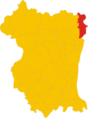
Clauzetto (Clauzetto)
- Italian comune
Clauzetto is a picturesque village located in the province of Pordenone in the Friuli Venezia Giulia region of Italy. Surrounded by beautiful natural landscapes, it offers various hiking opportunities perfect for outdoor enthusiasts.
Hiking Highlights in Clauzetto:
-
Scenic Trails: The trails around Clauzetto vary from easy walks to more challenging hikes. Many of these trails provide stunning views of the surrounding mountains and valleys and lead through lush forests and quaint villages.
-
Monte Sernio: One of the notable peaks in the area, Monte Sernio offers a rewarding hiking experience with panoramic views. It’s a great option for those looking for a moderate difficulty level hike.
-
Nature and Wildlife: The region is rich in biodiversity, so hikers might encounter various flora and fauna along the trails. Be sure to bring your binoculars for birdwatching!
-
Historical and Cultural Sites: Some hiking routes also lead to historical sites, including old churches and ruins. This provides a nice mix of outdoor adventure and cultural exploration.
-
Local Tips:
- Best Time to Visit: Spring and early autumn are ideal for hiking due to mild weather and blooming flora.
- Trail Maps: Make sure to have a reliable trail map or a GPS device, as some trails may not be well-marked.
- Safety Precautions: Always check the weather forecast before heading out and inform someone about your hiking plans. Wear proper hiking gear and carry enough water and snacks.
-
Hiking Groups: If you're new to the area or prefer hiking with others, consider joining a local hiking group or tour. They often have the expertise to guide you through the best routes and hidden gems.
Whether you're an experienced hiker or a beginner, Clauzetto offers a charming setting for enjoying nature and the tranquility of the Friulian countryside. Happy hiking!
- Country:

- Postal Code: 33090
- Local Dialing Code: 0427
- Licence Plate Code: PN
- Coordinates: 46° 14' 0" N, 12° 55' 0" E


- GPS tracks (wikiloc): [Link]
- AboveSeaLevel: 454 м m
- Area: 28.31 sq km
- Population: 380
- Web site: http://www.comune.clauzetto.pn.it
- Wikipedia en: wiki(en)
- Wikipedia: wiki(it)
- Wikidata storage: Wikidata: Q53164
- Wikipedia Commons Category: [Link]
- Freebase ID: [/m/0gqz6z]
- GeoNames ID: Alt: [6537928]
- VIAF ID: Alt: [139996864]
- OSM relation ID: [79112]
- TGN ID: [7047233]
- ISTAT ID: 093016
- Italian cadastre code: C791
Shares border with regions:
Castelnovo del Friuli
- Italian comune
 Hiking in Castelnovo del Friuli
Castelnovo del Friuli is a charming municipality located in the Friuli Venezia Giulia region of northern Italy. It's an excellent destination for hiking enthusiasts, as it offers a variety of landscapes, including hills, forests, and stunning views of the surrounding mountains....
- Country:

- Postal Code: 33090
- Local Dialing Code: 0427
- Licence Plate Code: PN
- Coordinates: 46° 12' 31" N, 12° 53' 37" E


- GPS tracks (wikiloc): [Link]
- AboveSeaLevel: 244 м m
- Area: 22.48 sq km
- Population: 864
- Web site: [Link]


Pinzano al Tagliamento
- Italian comune
 Hiking in Pinzano al Tagliamento
Pinzano al Tagliamento, located in the Friuli Venezia Giulia region of northeastern Italy, is an excellent destination for hiking enthusiasts. The area is characterized by its stunning natural landscapes, including rolling hills, the Tagliamento River, and lush forests....
- Country:

- Postal Code: 33094
- Local Dialing Code: 0432
- Licence Plate Code: PN
- Coordinates: 46° 10' 59" N, 12° 56' 43" E


- GPS tracks (wikiloc): [Link]
- AboveSeaLevel: 201 м m
- Area: 21.95 sq km
- Population: 1514
- Web site: [Link]


Tramonti di Sotto
- Italian comune
Tramonti di Sotto is a picturesque village located in the Friuli Venezia Giulia region of northeastern Italy, nestled within the Julian Alps. The area is known for its natural beauty, offering a range of hiking opportunities suitable for various skill levels. Here are some highlights of hiking in the region:...
- Country:

- Postal Code: 33090
- Local Dialing Code: 0427
- Licence Plate Code: PN
- Coordinates: 46° 17' 0" N, 12° 48' 0" E


- GPS tracks (wikiloc): [Link]
- AboveSeaLevel: 366 м m
- Area: 85.55 sq km
- Population: 367
- Web site: [Link]


Vito d'Asio
- Italian comune
Vito d'Asio is a picturesque village located in the Friuli Venezia Giulia region of northern Italy. Surrounded by the beautiful landscapes of the eastern Alps, this area offers various hiking opportunities for both beginners and experienced hikers. Here are some highlights and tips for hiking in Vito d'Asio:...
- Country:

- Postal Code: 33090
- Local Dialing Code: 0427
- Licence Plate Code: PN
- Coordinates: 46° 14' 0" N, 12° 56' 0" E


- GPS tracks (wikiloc): [Link]
- AboveSeaLevel: 381 м m
- Area: 53.72 sq km
- Population: 734
- Web site: [Link]
