.jpg)
Clisson (Clisson)

- commune in Loire-Atlantique, France
- Country:

- Postal Code: 44190
- Coordinates: 47° 5' 13" N, 1° 17' 1" E


- GPS tracks (wikiloc): [Link]
- Area: 11.3 sq km
- Population: 6883
- Web site: http://www.mairie-clisson.com
- Wikipedia en: wiki(en)
- Wikipedia: wiki(fr)
- Wikidata storage: Wikidata: Q383472
- Wikipedia Commons Gallery: [Link]
- Wikipedia Commons Category: [Link]
- Wikipedia Commons Maps Category: [Link]
- Freebase ID: [/m/07vjgc]
- Freebase ID: [/m/07vjgc]
- GeoNames ID: Alt: [3024578]
- GeoNames ID: Alt: [3024578]
- SIREN number: [214400434]
- SIREN number: [214400434]
- BnF ID: [152602120]
- BnF ID: [152602120]
- VIAF ID: Alt: [155211568]
- VIAF ID: Alt: [155211568]
- archINFORM location ID: [6877]
- archINFORM location ID: [6877]
- Library of Congress authority ID: Alt: [n91078605]
- Library of Congress authority ID: Alt: [n91078605]
- MusicBrainz area ID: [1b484afb-e9cc-4d86-affb-52f0773e802a]
- MusicBrainz area ID: [1b484afb-e9cc-4d86-affb-52f0773e802a]
- INSEE municipality code: 44043
- INSEE municipality code: 44043
Shares border with regions:


Gétigné
- commune in Loire-Atlantique, France
- Country:
- Postal Code: 44190
- Coordinates: 47° 4' 32" N, 1° 14' 58" E
- GPS tracks (wikiloc): [Link]
- Area: 23.97 sq km
- Population: 3614
- Web site: [Link]

Saint-Hilaire-de-Clisson
- commune in Loire-Atlantique, France
- Country:
- Postal Code: 44190
- Coordinates: 47° 3' 44" N, 1° 18' 28" E
- GPS tracks (wikiloc): [Link]
- Area: 18.43 sq km
- Population: 2222
- Web site: [Link]


Mouzillon
- commune in Loire-Atlantique, France
- Country:
- Postal Code: 44330
- Coordinates: 47° 8' 29" N, 1° 16' 56" E
- GPS tracks (wikiloc): [Link]
- Area: 16.5 sq km
- Population: 2764
- Web site: [Link]

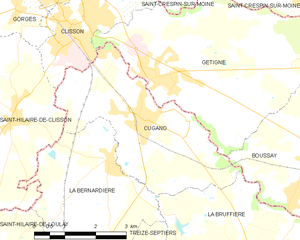
Cugand
- commune in Vendée, France
- Country:
- Postal Code: 85610
- Coordinates: 47° 3' 45" N, 1° 15' 16" E
- GPS tracks (wikiloc): [Link]
- Area: 13.47 sq km
- Population: 3448
- Web site: [Link]

Gorges
- commune in Loire-Atlantique, France
- Country:
- Postal Code: 44190
- Coordinates: 47° 6' 6" N, 1° 18' 14" E
- GPS tracks (wikiloc): [Link]
- Area: 15.77 sq km
- Population: 4495
- Web site: [Link]
Saint-Crespin-sur-Moine
- former commune in Maine-et-Loire, France
- Country:
- Postal Code: 49230
- Coordinates: 47° 5' 56" N, 1° 11' 10" E
- GPS tracks (wikiloc): [Link]
- Area: 20.11 sq km
- Population: 1586