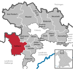
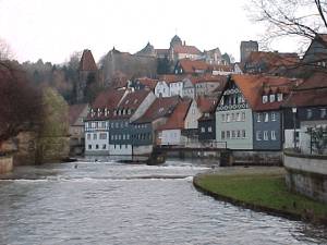
Coburg (Landkreis Coburg)
.svg)
- district in Bavaria, Germany
 Hiking in Coburg
Coburg district, located in Bavaria, Germany, offers a variety of hiking opportunities for outdoor enthusiasts. The region is characterized by beautiful landscapes, including rolling hills, woodlands, and scenic views that make for enjoyable hiking experiences.
Highlights of Hiking in Coburg District:
-
Biodiversity and Nature:
- The area is rich in flora and fauna due to its variety of ecosystems, which include forests, meadows, and rivers. Hikers can enjoy observing wildlife and the seasonal changes in the landscape.
-
Trails and Routes:
- Coburg district features numerous well-marked trails suitable for hikers of all skill levels. The local hiking clubs and tourist offices often provide maps and information about the most popular routes.
- Notable trails include sections of the Frankenweg, a long-distance hiking trail that traverses the Franconian region, providing stunning views and traversing picturesque villages.
-
Historical Significance:
- While hiking, you can explore historical sites, such as castles, churches, and old towns. Coburg itself boasts the impressive Coburg Fortress (Veste Coburg), which is worth a visit.
-
Suitable for All Levels:
- The trails in Coburg offer something for everyone, from gentle walks suitable for families to more challenging hikes for experienced trekkers.
-
Seasonal Hiking:
- Each season in Coburg offers unique beauty. Autumn presents colorful foliage, while spring brings blooming flowers, making it a year-round hiking destination.
-
Local Culture:
- As you hike through the region, you may encounter local festivals, culinary specialties, and crafts, providing a rich cultural experience alongside your outdoor adventure.
-
Accessibility:
- Coburg is well-connected by public transportation, making it easier to reach starting points of various hiking trails.
Tips for Hiking in Coburg District:
- Check Weather: Always check the weather forecast before heading out, as conditions can change rapidly in mountainous regions.
- Gear Up Accordingly: Wear appropriate hiking shoes, and consider layering your clothing for comfort.
- Stay Hydrated: Carry enough water and snacks to keep your energy levels up during your hikes.
- Follow Marked Trails: Stick to marked paths to protect local wildlife and vegetation.
Whether you're looking for a leisurely stroll or an adventurous hike, Coburg district is a wonderful area to explore the great outdoors while enjoying the beauty of Bavaria.
- Country:

- Capital: Coburg
- Licence Plate Code: NEC; CO
- Coordinates: 50° 16' 0" N, 10° 55' 0" E


- GPS tracks (wikiloc): [Link]
- AboveSeaLevel: 306 м m
- Area: 592.00 sq km
- Population: 82033
- Web site: http://www.landkreis-coburg.de/
- Wikipedia en: wiki(en)
- Wikipedia: wiki(de)
- Wikidata storage: Wikidata: Q10440
- Wikipedia Commons Category: [Link]
- Freebase ID: [/m/01kc92]
- GeoNames ID: Alt: [2939950]
- VIAF ID: Alt: [159481801]
- OSM relation ID: [62561]
- GND ID: Alt: [4010327-4]
- archINFORM location ID: [3374]
- Library of Congress authority ID: Alt: [n83038419]
- Quora topic ID: [Coburg]
- Historical Gazetteer (GOV) ID: [adm_139473]
- Bavarikon ID: [ODB_A00002012]
- NUTS code: [DE247]
- BabelNet ID: [01782404n]
- German district key: 09473
Includes regions:
Köllnholz
- unincorporated area in Germany
Hiking in Köllnholz
Köllnholz is a beautiful area in Germany that offers a range of hiking opportunities, especially for those who enjoy nature and tranquility. Nestled in the heart of lush forests and scenic landscapes, Köllnholz can be a great destination for both experienced hikers and those looking for a more leisurely stroll....
- Country:
- Coordinates: 50° 17' 0" N, 10° 57' 0" E
- GPS tracks (wikiloc): [Link]

Dörfles-Esbach
- municipality of Germany
Hiking in Dörfles-Esbach
Dörfles-Esbach is a small municipality in Bavaria, Germany, situated near the city of Coburg. While it may not be as widely known as other hiking destinations, it offers a charming experience for nature enthusiasts and hikers seeking peaceful trails....
- Country:
- Postal Code: 96487
- Local Dialing Code: 09561
- Licence Plate Code: CO
- Coordinates: 50° 16' 50" N, 10° 59' 37" E
- GPS tracks (wikiloc): [Link]
- AboveSeaLevel: 306 м m
- Area: 3.83 sq km
- Population: 3461
- Web site: [Link]


Ahorn, Bavaria
- municipality of Germany
Hiking in Ahorn, Bavaria
Ahorn, located in Bavaria, Germany, is a beautiful destination for hiking enthusiasts. It is nestled in the scenic landscape of the Bavarian countryside and is surrounded by lush forests, rolling hills, and picturesque views. Here are some key aspects of hiking in Ahorn:...
- Country:
- Postal Code: 96482
- Local Dialing Code: 09565; 09561
- Licence Plate Code: CO
- Coordinates: 50° 14' 0" N, 10° 57' 0" E
- GPS tracks (wikiloc): [Link]
- AboveSeaLevel: 335 м m
- Area: 19.85 sq km
- Population: 4262
- Web site: [Link]

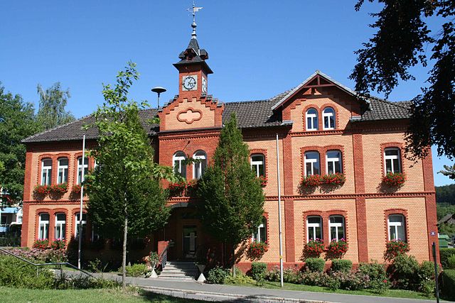
Großheirath
- municipality in Bavaria, Germany
Hiking in Großheirath
Großheirath is a small town in Bavaria, Germany, located close to the city of Coburg. The surrounding area offers various opportunities for hiking enthusiasts, making it a great destination for enjoying nature, exploring scenic trails, and experiencing local wildlife....
- Country:
- Postal Code: 96269
- Local Dialing Code: 09565
- Licence Plate Code: CO
- Coordinates: 50° 10' 0" N, 10° 56' 0" E
- GPS tracks (wikiloc): [Link]
- AboveSeaLevel: 303 м m
- Area: 22.27 sq km
- Population: 1877
- Web site: [Link]

Neustadt bei Coburg
- town in Bavaria, Germany
Hiking in Neustadt bei Coburg
Neustadt bei Coburg, located in Bavaria, Germany, is surrounded by picturesque landscapes and offers various hiking opportunities that cater to different skill levels. Here are some highlights and tips for hiking in this region:...
- Country:
- Postal Code: 96465
- Local Dialing Code: 09568
- Coordinates: 50° 19' 47" N, 11° 7' 14" E
- GPS tracks (wikiloc): [Link]
- AboveSeaLevel: 340 м m
- Area: 61.90 sq km
- Population: 15227
- Web site: [Link]


Bad Rodach
- municipality of Germany
Hiking in Bad Rodach
Bad Rodach, a charming town in Bavaria, Germany, offers a variety of hiking opportunities for outdoor enthusiasts. Nestled in the scenic landscapes of the Franconian region, it's a great place for both casual walkers and more serious hikers....
- Country:
- Postal Code: 96476
- Local Dialing Code: 09564
- Licence Plate Code: CO
- Coordinates: 50° 20' 0" N, 10° 47' 0" E
- GPS tracks (wikiloc): [Link]
- AboveSeaLevel: 320 м m
- Area: 77.65 sq km
- Population: 6399
- Web site: [Link]


Niederfüllbach
- municipality of Germany
Hiking in Niederfüllbach
Niederfüllbach, located in Bavaria, Germany, offers a range of hiking opportunities for outdoor enthusiasts. The surrounding region features scenic landscapes, rolling hills, and lush forests, making it an excellent location for both casual walkers and experienced hikers....
- Country:
- Postal Code: 96489
- Local Dialing Code: 09565
- Licence Plate Code: CO
- Coordinates: 50° 13' 0" N, 10° 59' 0" E
- GPS tracks (wikiloc): [Link]
- AboveSeaLevel: 280 м m
- Area: 2.59 sq km
- Population: 1241
- Web site: [Link]


Untersiemau
- municipality of Germany
Hiking in Untersiemau
Untersiemau is a quaint village located in Bavaria, Germany, and it's surrounded by beautiful landscapes that are perfect for hiking enthusiasts. Here are some highlights of hiking in and around Untersiemau:...
- Country:
- Postal Code: 96253
- Local Dialing Code: 09565
- Licence Plate Code: CO
- Coordinates: 50° 11' 39" N, 10° 58' 23" E
- GPS tracks (wikiloc): [Link]
- AboveSeaLevel: 299 м m
- Area: 20.49 sq km
- Population: 3802
- Web site: [Link]


Sonnefeld
- municipality of Germany
Hiking in Sonnefeld
Sonnefeld is a picturesque town located in Bavaria, Germany, surrounded by beautiful landscapes that are perfect for hiking. The region offers a mix of forested areas, rolling hills, and scenic trails that cater to various skill levels. Here are some key points to consider when planning a hike in and around Sonnefeld:...
- Country:
- Postal Code: 96242
- Local Dialing Code: 09562
- Licence Plate Code: CO
- Coordinates: 50° 13' 0" N, 11° 7' 0" E
- GPS tracks (wikiloc): [Link]
- AboveSeaLevel: 318 м m
- Area: 34.69 sq km
- Population: 4885
- Web site: [Link]


Weitramsdorf
- municipality of Germany
Hiking in Weitramsdorf
Weitramsdorf, a charming municipality located in Bavaria, Germany, offers plenty of opportunities for hiking enthusiasts. Nestled in a picturesque landscape characterized by rolling hills, forests, and scenic views, it serves as an excellent base for outdoor activities....
- Country:
- Postal Code: 96479
- Local Dialing Code: 09561
- Licence Plate Code: CO
- Coordinates: 50° 15' 0" N, 10° 52' 0" E
- GPS tracks (wikiloc): [Link]
- AboveSeaLevel: 300 м m
- Area: 33.71 sq km
- Population: 4338
- Web site: [Link]

Ebersdorf bei Coburg
- municipality of Germany
Hiking in Ebersdorf bei Coburg
Ebersdorf bei Coburg is a charming village in Bavaria, Germany, surrounded by beautiful landscapes and nature. While it may not be as widely known for hiking as some other German regions, it offers several opportunities for outdoor enthusiasts to explore the surrounding area....
- Country:
- Postal Code: 96237
- Local Dialing Code: 09562
- Licence Plate Code: CO
- Coordinates: 50° 13' 12" N, 11° 4' 14" E
- GPS tracks (wikiloc): [Link]
- AboveSeaLevel: 310 м m
- Area: 26.50 sq km
- Population: 5540
- Web site: [Link]

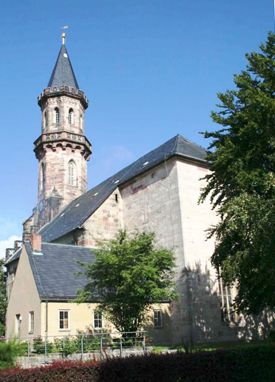
Seßlach
- municipality of Germany
Hiking in Seßlach
Seßlach is a charming town in Bavaria, Germany, known for its picturesque medieval architecture and beautiful surrounding landscapes. While the town itself is small, it offers access to several hiking opportunities in the surrounding area, particularly in the Franconian Switzerland region....
- Country:
- Postal Code: 96145
- Local Dialing Code: 09569
- Licence Plate Code: CO
- Coordinates: 50° 11' 0" N, 10° 50' 0" E
- GPS tracks (wikiloc): [Link]
- AboveSeaLevel: 271 м m
- Area: 72.51 sq km
- Population: 3962
- Web site: [Link]


Weidhausen
- municipality of Germany
Hiking in Weidhausen
Weidhausen is a small town located in Bavaria, Germany. While it may not be as widely known as some of the larger hiking destinations in Germany, it offers a peaceful and scenic environment for those who enjoy exploring the outdoors....
- Country:
- Postal Code: 96279
- Local Dialing Code: 09562
- Licence Plate Code: CO
- Coordinates: 50° 12' 13" N, 11° 8' 24" E
- GPS tracks (wikiloc): [Link]
- AboveSeaLevel: 308 м m
- Area: 9.61 sq km
- Population: 2971
- Web site: [Link]


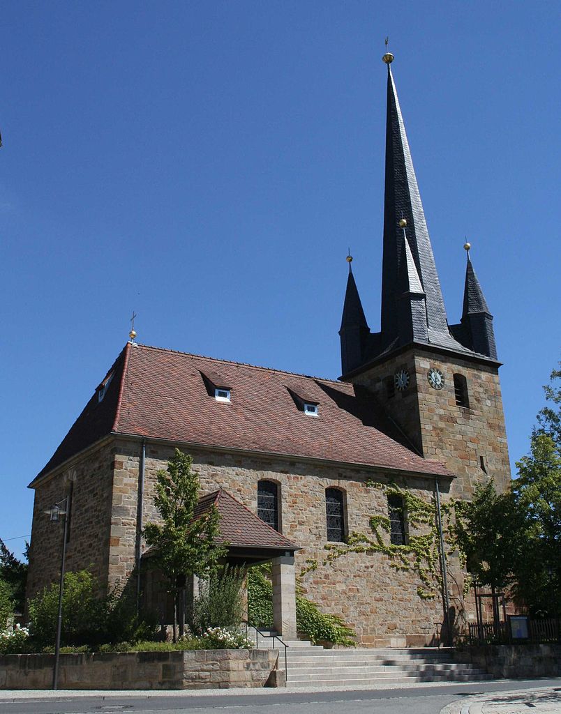
Meeder
- municipality of Germany
Hiking in Meeder
Meeder, a small town in the Oberfranken region of Bavaria, Germany, offers some picturesque hiking opportunities. While the town itself is relatively small, it is surrounded by beautiful landscapes and trails that cater to various skill levels. Here are some key points about hiking in and around Meeder:...
- Country:
- Postal Code: 96484
- Local Dialing Code: 09566
- Licence Plate Code: CO
- Coordinates: 50° 19' 18" N, 10° 54' 21" E
- GPS tracks (wikiloc): [Link]
- AboveSeaLevel: 326 м m
- Area: 79.59 sq km
- Population: 3546
- Web site: [Link]


Grub am Forst
- municipality of Germany
Hiking in Grub am Forst
Grub am Forst is a charming municipality located in Bavaria, Germany, surrounded by picturesque landscapes that are perfect for hiking enthusiasts. Here are some highlights about hiking in this area:...
- Country:
- Postal Code: 96271
- Local Dialing Code: 09560
- Licence Plate Code: CO
- Coordinates: 50° 13' 0" N, 11° 1' 0" E
- GPS tracks (wikiloc): [Link]
- AboveSeaLevel: 300 м m
- Area: 11.97 sq km
- Population: 2913
- Web site: [Link]


Rödental
- municipality of Germany
Hiking in Rödental
Rödental, located in Bavaria, Germany, is a charming town surrounded by beautiful landscapes that offer excellent hiking opportunities. The region is characterized by lush forests, rolling hills, and picturesque views, making it suitable for hikers of all levels....
- Country:
- Postal Code: 96472
- Local Dialing Code: 09563
- Licence Plate Code: CO
- Coordinates: 50° 17' 0" N, 11° 4' 0" E
- GPS tracks (wikiloc): [Link]
- AboveSeaLevel: 350 м m
- Area: 49.96 sq km
- Population: 13068
- Web site: [Link]


Lautertal
- municipality of Germany
Hiking in Lautertal
Lautertal in Bavaria is a beautiful area for hiking, known for its picturesque landscapes, dense forests, and serene valleys. Here are some highlights and tips for hiking in Lautertal:...
- Country:
- Postal Code: 96486
- Local Dialing Code: 09566; 09561
- Licence Plate Code: CO
- Coordinates: 50° 20' 0" N, 10° 58' 0" E
- GPS tracks (wikiloc): [Link]
- AboveSeaLevel: 433 м m
- Area: 30.34 sq km
- Population: 3141
- Web site: [Link]


Itzgrund
- municipality of Germany
Hiking in Itzgrund
Itzgrund is a beautiful area in Germany, located in the state of Bavaria, known for its stunning natural landscapes, which make it a great destination for hiking enthusiasts. While Itzgrund itself may not be a widely recognized hiking destination compared to larger parks or mountain ranges, the surrounding areas provide plenty of opportunities for outdoor activities. Here’s a general overview of what to expect when hiking in Itzgrund:...
- Country:
- Postal Code: 96274
- Local Dialing Code: 09573; 09533
- Licence Plate Code: CO
- Coordinates: 50° 7' 0" N, 10° 54' 0" E
- GPS tracks (wikiloc): [Link]
- AboveSeaLevel: 269 м m
- Area: 33.08 sq km
- Population: 1825
- Web site: [Link]
Callenberger Forst-West
- unincorporated area in Germany
Hiking in Callenberger Forst-West
Callenberger Forst-West, located in the region of Lower Saxony, Germany, is a great destination for hiking enthusiasts. This forest area is known for its tranquil nature, rich biodiversity, and scenic trails, making it an ideal spot for both casual walkers and avid hikers. Here are some key points to consider when planning a hike in Callenberger Forst-West:...
- Country:
- Coordinates: 50° 17' 0" N, 10° 50' 0" E
- GPS tracks (wikiloc): [Link]
Gellnhausen
- unincorporated area in Germany
Hiking in Gellnhausen
Gelnhausen, located in the state of Hesse, Germany, is surrounded by picturesque landscapes and offers several hiking opportunities. The region is characterized by its rolling hills, wooded areas, and historical sites, making it an appealing destination for outdoor enthusiasts....
- Country:
- Coordinates: 50° 22' 0" N, 10° 47' 0" E
- GPS tracks (wikiloc): [Link]
Shares border with regions:
Kronach
- district in Bavaria, Germany
Hiking in Kronach
Kronach, located in Bavaria, Germany, is an excellent destination for hiking enthusiasts. The district is characterized by its beautiful landscapes, rich history, and diverse trails suitable for all levels of hikers. Here are some highlights regarding hiking in Kronach:...
- Country:
- Capital: Kronach
- Licence Plate Code: SAN; KC
- Coordinates: 50° 19' 48" N, 11° 22' 12" E
- GPS tracks (wikiloc): [Link]
- AboveSeaLevel: 412 м m
- Area: 651.00 sq km
- Population: 75353
- Web site: [Link]

Lichtenfels
- district in Bavaria, Germany
Hiking in Lichtenfels
Lichtenfels is a district in Bavaria, Germany, known for its picturesque landscapes and scenic hiking trails. Nestled in the heart of the Franconian region, it offers a variety of hiking opportunities suitable for different skill levels and preferences. Here are some key points about hiking in Lichtenfels:...
- Country:
- Capital: Lichtenfels
- Licence Plate Code: STE; LIF
- Coordinates: 50° 6' 36" N, 11° 7' 12" E
- GPS tracks (wikiloc): [Link]
- AboveSeaLevel: 422 м m
- Area: 552.00 sq km
- Population: 65602
- Web site: [Link]
Bamberg
- district in Bavaria, Germany
Hiking in Bamberg
Bamberg district, located in Bavaria, Germany, offers a variety of scenic hiking opportunities amidst its charming landscapes, historical sites, and cultural attractions. Here’s an overview of what you can expect when hiking in the region:...
- Country:
- Capital: Bamberg
- Licence Plate Code: BA
- Coordinates: 49° 49' 48" N, 10° 49' 48" E
- GPS tracks (wikiloc): [Link]
- AboveSeaLevel: 275 м m
- Area: 1168.00 sq km
- Population: 119829
- Web site: [Link]

Haßberge
- district in Bavaria, Germany
Hiking in Haßberge
The Haßberge district, located in the northern part of Bavaria, Germany, is known for its beautiful landscapes, rolling hills, dense forests, and quaint villages, making it an excellent destination for hiking enthusiasts. Here are some key points about hiking in the Haßberge district:...
- Country:
- Capital: Haßfurt
- Licence Plate Code: HAS
- Coordinates: 50° 4' 48" N, 10° 40' 12" E
- GPS tracks (wikiloc): [Link]
- AboveSeaLevel: 368 м m
- Area: 956.00 sq km
- Population: 80257
- Web site: [Link]
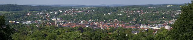
Coburg
- town in Bavaria, Germany
Hiking in Coburg
Coburg, situated in the northern part of Bavaria, Germany, offers attractive hiking opportunities for outdoor enthusiasts. The region is characterized by its beautiful landscapes, including rolling hills, lush forests, and historic sites, making it an appealing destination for hikers of all skill levels....
- Country:
- Postal Code: 96450
- Local Dialing Code: 09561
- Licence Plate Code: CO
- Coordinates: 50° 16' 0" N, 10° 58' 0" E
- GPS tracks (wikiloc): [Link]
- AboveSeaLevel: 292 м m
- Area: 48.30 sq km
- Population: 40994
- Web site: [Link]
Hildburghausen
- district of Thuringia, Germany
Hiking in Hildburghausen
Hildburghausen is a picturesque district located in the state of Thuringia, Germany, known for its diverse landscapes, history, and plenty of outdoor activities, including hiking. Here are some highlights for hiking in the Hildburghausen district:...
- Country:
- Licence Plate Code: HBN
- Coordinates: 50° 25' 12" N, 10° 45' 0" E
- GPS tracks (wikiloc): [Link]
- AboveSeaLevel: 482 м m
- Area: 938.42 sq km
- Population: 64524
- Web site: [Link]
Sonneberg
- district of Thuringia, Germany
Hiking in Sonneberg
Sonneberg, located in the southern part of Germany, in the state of Thuringia, offers a variety of hiking opportunities that cater to different skill levels and preferences. The district is characterized by its beautiful landscapes, including rolling hills, dense forests, and picturesque valleys....
- Country:
- Licence Plate Code: SON; NH
- Coordinates: 50° 24' 36" N, 11° 7' 48" E
- GPS tracks (wikiloc): [Link]
- AboveSeaLevel: 594 м m
- Area: 433.61 sq km
- Population: 56818
- Web site: [Link]