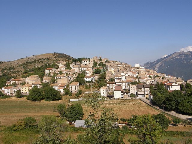
Collepietro (Collepietro)
.svg)
- Italian comune
 Hiking in Collepietro
Collepietro is a charming town located in the Abruzzo region of Italy, known for its stunning landscapes and proximity to the Apennine mountains. The area offers a variety of hiking opportunities, making it a great destination for outdoor enthusiasts.
Hiking in Collepietro
Trails and Routes
-
Monte Stambecco: A popular route leads hikers up to Monte Stambecco, offering breathtaking views of the surrounding mountains and valleys. The trail is moderately challenging and showcases diverse flora and fauna.
-
Path of the Puzzled: This is a scenic route that winds through the countryside, highlighting the picturesque landscapes. It is suitable for families and can be a nice half-day hike.
-
Network of Trails: There are numerous interconnected trails around Collepietro that cater to varying skill levels. Hikers can explore different paths leading to panoramic viewpoints, valleys, and historical sites.
What to Expect
- Scenic Views: The trails provide beautiful vistas of the Apennines, especially during sunrise and sunset.
- Wildlife: Keep an eye out for local wildlife, including various bird species and other animals typical of the Abruzzo region.
- Local Flora: The area boasts rich biodiversity, with many native plants, especially during the spring and summer seasons.
Best Time to Hike
- Spring and Autumn: These seasons offer mild temperatures and stunning natural colors, making it ideal for hiking.
- Summer: While it can be hot, early morning or late afternoon hikes are still enjoyable.
Preparation and Safety
- Gear: Wear appropriate hiking shoes, and consider bringing trekking poles for steeper sections.
- Weather Check: Always check the weather forecast before heading out to ensure safety.
- Water and Snacks: Carry enough water and snacks, especially for longer hikes, as facilities may be limited on the trails.
Conclusion
Hiking in Collepietro provides a wonderful opportunity to immerse yourself in nature while experiencing the beauty of Abruzzo. Whether you're a seasoned hiker or a beginner, the trails in and around Collepietro offer something for everyone. Don’t forget your camera to capture the stunning scenery!
- Country:

- Postal Code: 67020
- Local Dialing Code: 0862
- Licence Plate Code: AQ
- Coordinates: 42° 13' 22" N, 13° 46' 49" E


- GPS tracks (wikiloc): [Link]
- AboveSeaLevel: 849 м m
- Area: 15.21 sq km
- Population: 229
- Web site: http://www.comune.collepietro.aq.it/hh/index.php
- Wikipedia en: wiki(en)
- Wikipedia: wiki(it)
- Wikidata storage: Wikidata: Q50088
- Wikipedia Commons Gallery: [Link]
- Wikipedia Commons Category: [Link]
- Freebase ID: [/m/0fg4pf]
- GeoNames ID: Alt: [6540708]
- OSM relation ID: [41856]
- Google Maps Customer ID: [290851176775805728]
- ISTAT ID: 066040
- Italian cadastre code: C866
Shares border with regions:


Capestrano
- Italian comune
Hiking in Capestrano
Capestrano, a picturesque village located in the Abruzzo region of Italy, offers hikers a unique blend of natural beauty, historical sites, and cultural experiences. Here are some key points about hiking in Capestrano:...
- Country:
- Postal Code: 67022
- Local Dialing Code: 0862
- Licence Plate Code: AQ
- Coordinates: 42° 16' 10" N, 13° 46' 0" E
- GPS tracks (wikiloc): [Link]
- AboveSeaLevel: 465 м m
- Area: 43.66 sq km
- Population: 897
- Web site: [Link]


Navelli
- Italian comune
Hiking in Navelli
Navelli is a charming little area located in the Abruzzo region of Italy, known for its picturesque landscapes, historical sites, and rich agricultural traditions, particularly in saffron cultivation. Hiking in and around Navelli offers stunning views of the surrounding Apennine Mountains, lush valleys, and quaint villages....
- Country:
- Postal Code: 67020
- Local Dialing Code: 0862
- Licence Plate Code: AQ
- Coordinates: 42° 14' 14" N, 13° 43' 47" E
- GPS tracks (wikiloc): [Link]
- AboveSeaLevel: 760 м m
- Area: 42 sq km
- Population: 541
- Web site: [Link]

San Benedetto in Perillis
- Italian comune
Hiking in San Benedetto in Perillis
San Benedetto in Perillis is a picturesque small town located in the Abruzzo region of Italy, nestled in the Apennine Mountains. Its stunning natural scenery, dotted with historic architecture and charming local culture, makes it an appealing destination for hiking enthusiasts. Here are some key points about hiking in this area:...
- Country:
- Postal Code: 67020
- Local Dialing Code: 0862
- Licence Plate Code: AQ
- Coordinates: 42° 11' 7" N, 13° 46' 18" E
- GPS tracks (wikiloc): [Link]
- AboveSeaLevel: 878 м m
- Area: 19.1 sq km
- Population: 103
- Web site: [Link]


Bussi sul Tirino
- Italian comune
Hiking in Bussi sul Tirino
Bussi sul Tirino is a picturesque town located in the Abruzzo region of Italy, nestled along the Tirino River and surrounded by beautiful mountainous landscapes. This area offers a variety of hiking opportunities, catering to both novice and experienced hikers. Here are some highlights to consider when planning your hiking adventure in Bussi sul Tirino:...
- Country:
- Postal Code: 65022
- Local Dialing Code: 085
- Licence Plate Code: PE
- Coordinates: 42° 13' 0" N, 13° 49' 0" E
- GPS tracks (wikiloc): [Link]
- AboveSeaLevel: 344 м m
- Area: 25.91 sq km
- Population: 2447
- Web site: [Link]


Popoli
- Italian comune
Hiking in Popoli
Popoli, located in the Abruzzo region of Italy, is known for its stunning natural landscapes and is an excellent destination for hiking enthusiasts. Nestled in the foothills of the Apennine Mountains, Popoli offers a variety of trails that cater to different skill levels, from leisurely walks to more challenging hikes....
- Country:
- Postal Code: 65026
- Local Dialing Code: 085
- Licence Plate Code: PE
- Coordinates: 42° 10' 7" N, 13° 49' 48" E
- GPS tracks (wikiloc): [Link]
- AboveSeaLevel: 254 м m
- Area: 35.04 sq km
- Population: 5035
- Web site: [Link]