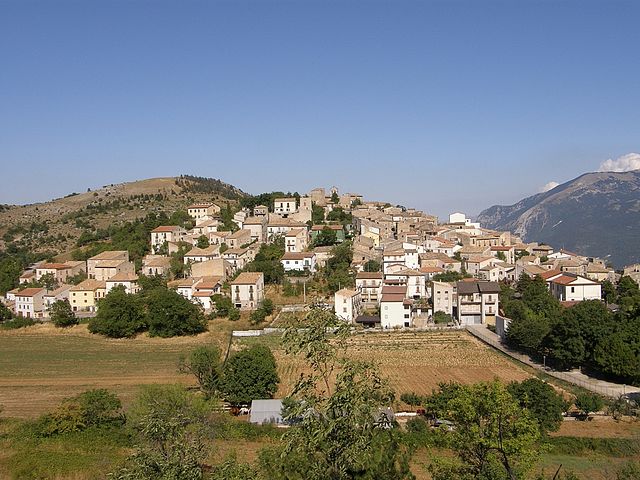
Popoli (Popoli)
.svg)
- Italian comune
 Hiking in Popoli
Popoli, located in the Abruzzo region of Italy, is known for its stunning natural landscapes and is an excellent destination for hiking enthusiasts. Nestled in the foothills of the Apennine Mountains, Popoli offers a variety of trails that cater to different skill levels, from leisurely walks to more challenging hikes.
Key Hiking Areas Around Popoli:
-
Majella National Park: Just a short distance from Popoli, this national park features breathtaking mountain scenery, diverse fauna, and flora. There are numerous trails to choose from, many of which lead to panoramic viewpoints and historical sites. Popular trails include the ascent to the peak of Monte Amaro, the highest mountain in the Majella range.
-
Gorges of the Orfento River: This area is known for its spectacular gorges and lush vegetation. There are several trails that follow the river, allowing hikers to enjoy the coolness of the water while taking in the striking rock formations. The area is also home to various wildlife species, making it a great spot for nature lovers.
-
Local Trails: There are also many well-marked local trails around Popoli that showcase the beautiful countryside, ancient ruins, and traditional villages. These paths often lead through olive groves and vineyards, providing a more cultural experience alongside the natural beauty.
Considerations for Hiking in Popoli:
-
Weather: The best time for hiking in the area is typically during spring and fall when temperatures are mild, and the scenery is vibrant. Summer can be hot, while winter trails may be affected by snow.
-
Preparation: Always ensure you have the right gear, including sturdy hiking shoes, plenty of water, snacks, and a map or GPS device. Some trails may be remote, so it's advisable to let someone know your hiking plans.
-
Local Guidelines: Respect the natural environment by adhering to local guidelines, including any designated park rules, wildlife conservation efforts, and trail etiquette.
-
Accommodations: Popoli offers various lodging options, from hotels to agriturismos, which can provide a comfortable base from which to explore the surrounding hiking opportunities.
Exploring the hiking trails around Popoli allows visitors to enjoy some of the most beautiful landscapes that Italy has to offer while also experiencing its rich culture and history. Whether you're a seasoned hiker or a beginner, there are trails for everyone to enjoy.
- Country:

- Postal Code: 65026
- Local Dialing Code: 085
- Licence Plate Code: PE
- Coordinates: 42° 10' 7" N, 13° 49' 48" E


- GPS tracks (wikiloc): [Link]
- AboveSeaLevel: 254 м m
- Area: 35.04 sq km
- Population: 5035
- Web site: http://www.comune.popoli.pe.it
- Wikipedia en: wiki(en)
- Wikipedia: wiki(it)
- Wikidata storage: Wikidata: Q51384
- Wikipedia Commons Gallery: [Link]
- Wikipedia Commons Category: [Link]
- Freebase ID: [/m/0fg8w9]
- GeoNames ID: Alt: [6539828]
- VIAF ID: Alt: [248307770]
- OSM relation ID: [41815]
- MusicBrainz area ID: [4a2578ae-99fa-4c70-9b38-2e2be753cdc8]
- UN/LOCODE: [ITPAB]
- Digital Atlas of the Roman Empire ID: [26574]
- ISTAT ID: 068033
- Italian cadastre code: G878
Shares border with regions:


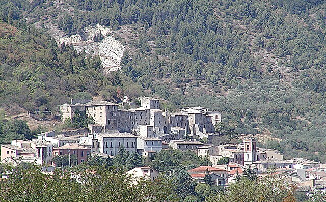
Collepietro
- Italian comune
Hiking in Collepietro
Collepietro is a charming town located in the Abruzzo region of Italy, known for its stunning landscapes and proximity to the Apennine mountains. The area offers a variety of hiking opportunities, making it a great destination for outdoor enthusiasts....
- Country:
- Postal Code: 67020
- Local Dialing Code: 0862
- Licence Plate Code: AQ
- Coordinates: 42° 13' 22" N, 13° 46' 49" E
- GPS tracks (wikiloc): [Link]
- AboveSeaLevel: 849 м m
- Area: 15.21 sq km
- Population: 229
- Web site: [Link]


Corfinio
- Italian comune
Hiking in Corfinio
Corfinio is a charming town located in the Abruzzo region of Italy, surrounded by stunning natural landscapes that offer a variety of hiking opportunities. Nestled on the edge of the Gran Sasso e Monti della Laga National Park, Corfinio provides a perfect base for hikers of all levels. Here are some highlights for hiking in the area:...
- Country:
- Postal Code: 67030
- Local Dialing Code: 0864
- Licence Plate Code: AQ
- Coordinates: 42° 7' 29" N, 13° 50' 33" E
- GPS tracks (wikiloc): [Link]
- AboveSeaLevel: 346 м m
- Area: 17.95 sq km
- Population: 1036
- Web site: [Link]

San Benedetto in Perillis
- Italian comune
Hiking in San Benedetto in Perillis
San Benedetto in Perillis is a picturesque small town located in the Abruzzo region of Italy, nestled in the Apennine Mountains. Its stunning natural scenery, dotted with historic architecture and charming local culture, makes it an appealing destination for hiking enthusiasts. Here are some key points about hiking in this area:...
- Country:
- Postal Code: 67020
- Local Dialing Code: 0862
- Licence Plate Code: AQ
- Coordinates: 42° 11' 7" N, 13° 46' 18" E
- GPS tracks (wikiloc): [Link]
- AboveSeaLevel: 878 м m
- Area: 19.1 sq km
- Population: 103
- Web site: [Link]
Vittorito
- Italian comune
Hiking in Vittorito
Vittorito is a small town located in the Abruzzo region of Italy, nestled in the mountainous landscape of the Apennines. The region is known for its stunning natural beauty, historical sites, and diverse hiking opportunities....
- Country:
- Postal Code: 67030
- Local Dialing Code: 0864
- Licence Plate Code: AQ
- Coordinates: 42° 7' 41" N, 13° 49' 3" E
- GPS tracks (wikiloc): [Link]
- AboveSeaLevel: 377 м m
- Area: 14.19 sq km
- Population: 850
- Web site: [Link]


Bussi sul Tirino
- Italian comune
Hiking in Bussi sul Tirino
Bussi sul Tirino is a picturesque town located in the Abruzzo region of Italy, nestled along the Tirino River and surrounded by beautiful mountainous landscapes. This area offers a variety of hiking opportunities, catering to both novice and experienced hikers. Here are some highlights to consider when planning your hiking adventure in Bussi sul Tirino:...
- Country:
- Postal Code: 65022
- Local Dialing Code: 085
- Licence Plate Code: PE
- Coordinates: 42° 13' 0" N, 13° 49' 0" E
- GPS tracks (wikiloc): [Link]
- AboveSeaLevel: 344 м m
- Area: 25.91 sq km
- Population: 2447
- Web site: [Link]


Tocco da Casauria
- Italian comune
Hiking in Tocco da Casauria
Tocco da Casauria is a charming village located in the Abruzzo region of Italy, nestled in the foothills of the Majella mountain range. This area is known for its stunning landscapes, rich history, and outdoor activities, including hiking. Here are some details about hiking in and around Tocco da Casauria:...
- Country:
- Postal Code: 65028
- Local Dialing Code: 085
- Licence Plate Code: PE
- Coordinates: 42° 13' 0" N, 13° 55' 0" E
- GPS tracks (wikiloc): [Link]
- AboveSeaLevel: 356 м m
- Area: 29.67 sq km
- Population: 2640
- Web site: [Link]