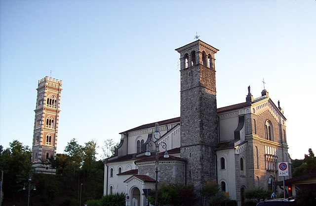
Colloredo di Monte Albano (Colloredo di Monte Albano)
.svg)
- Italian comune
 Hiking in Colloredo di Monte Albano
Colloredo di Monte Albano is a charming town located in the Friuli Venezia Giulia region of northeastern Italy. It is surrounded by beautiful landscapes, including hills and forests, which makes it an excellent location for hiking enthusiasts. Here’s a guide to what you might expect when hiking in this area:
Suggested Trails and Routes
-
Monte Albano Trail: This is a popular hiking route that offers stunning views of the surrounding countryside. The trail is moderate in difficulty and is suitable for both beginners and experienced hikers. Look out for the historical ruins and natural flora along the way.
-
Foresta di Cjavelons: This forested area near Colloredo di Monte Albano provides various trails where you can enjoy the tranquility of nature. The trails here can range from easy walks to more challenging hikes.
-
Hiking to Castello di Colloredo: A hike to the nearby medieval castle is recommended for those interested in history. The path leads through picturesque areas and offers panoramic views of the valley below.
Important Information
-
Difficulty Levels: Trails range from easy to moderate, making them suitable for families as well as more serious hikers. Always check trail markers and local advice regarding current trail conditions.
-
Best Time to Hike: Late spring (May to June) and early fall (September to October) are ideal times for hiking, as temperatures are generally mild and the natural scenery is in full bloom.
-
Equipment: It's advisable to wear sturdy hiking shoes and comfortable clothing. A backpack with water, snacks, and a map or a GPS device will enhance your experience.
Flora and Fauna
The area is rich in biodiversity. You may encounter various species of plants and wildlife unique to the region. Birdwatching can be particularly rewarding here, so consider bringing binoculars.
Local Amenities
Colloredo di Monte Albano has local eateries and shops where you can enjoy traditional Friulian cuisine and restock on supplies. It’s a good idea to explore local culture, including any ongoing events or festivals.
Safety Tips
- Always inform someone about your hiking plans, especially if hiking alone.
- Carry a first aid kit and know basic first aid knowledge.
- Be aware of weather conditions before and during your hike.
Hiking in Colloredo di Monte Albano can be a refreshing experience, offering both physical activity and the opportunity to appreciate the breathtaking natural landscapes of northeastern Italy. Enjoy your adventure!
- Country:

- Postal Code: 33010
- Local Dialing Code: 0432
- Licence Plate Code: UD
- Coordinates: 46° 10' 0" N, 13° 8' 0" E


- GPS tracks (wikiloc): [Link]
- AboveSeaLevel: 218 м m
- Area: 21.75 sq km
- Population: 2187
- Web site: http://www.comune.colloredodimontealbano.ud.it
- Wikipedia en: wiki(en)
- Wikipedia: wiki(it)
- Wikidata storage: Wikidata: Q53248
- Wikipedia Commons Category: [Link]
- Freebase ID: [/m/0gk8pt]
- GeoNames ID: Alt: [6542175]
- VIAF ID: Alt: [266841013]
- OSM relation ID: [79241]
- Library of Congress authority ID: Alt: [nr92035850]
- ISTAT ID: 030028
- Italian cadastre code: C885
Shares border with regions:


Buja
- Italian comune
Hiking in Buja
Hiking in Buja, a town located in the Friuli Venezia Giulia region of Italy, offers a range of scenic routes amid beautiful landscapes. Though Buja itself is not a major hiking destination, it serves as a gateway to numerous trails in the surrounding areas, particularly in the nearby Julian Alps and the Friuli Dolomites....
- Country:
- Postal Code: 33030
- Local Dialing Code: 0432
- Licence Plate Code: UD
- Coordinates: 46° 12' 44" N, 13° 7' 1" E
- GPS tracks (wikiloc): [Link]
- AboveSeaLevel: 213 м m
- Area: 25.51 sq km
- Population: 6484
- Web site: [Link]

Cassacco
- Italian comune
Hiking in Cassacco
Cassacco, located in the province of Udine in the Friuli Venezia Giulia region of northeastern Italy, offers a variety of hiking opportunities suitable for different skill levels. The surrounding landscape features rolling hills, vineyards, and panoramic views of the Alps, making it an attractive destination for outdoor enthusiasts....
- Country:
- Postal Code: 33010
- Local Dialing Code: 0432
- Licence Plate Code: UD
- Coordinates: 46° 10' 0" N, 13° 11' 0" E
- GPS tracks (wikiloc): [Link]
- AboveSeaLevel: 179 м m
- Area: 11.68 sq km
- Population: 2910
- Web site: [Link]


Fagagna
- Italian comune
Hiking in Fagagna
Fagagna is a charming village located in the Friuli-Venezia Giulia region of northeastern Italy. It's surrounded by beautiful landscapes, making it a great spot for hiking enthusiasts. Here are some details to consider for hiking in and around Fagagna:...
- Country:
- Postal Code: 33034
- Local Dialing Code: 0432
- Licence Plate Code: UD
- Coordinates: 46° 7' 0" N, 13° 5' 0" E
- GPS tracks (wikiloc): [Link]
- AboveSeaLevel: 177 м m
- Area: 37.19 sq km
- Population: 6296
- Web site: [Link]
Majano
- Italian comune
Hiking in Majano
Majano, a charming town in the Friuli Venezia Giulia region of northeastern Italy, offers a variety of hiking opportunities that showcase its beautiful landscapes, historic sites, and rich cultural heritage. Here are some key points to consider when planning a hiking trip in Majano and its surroundings:...
- Country:
- Postal Code: 33030
- Local Dialing Code: 0432
- Licence Plate Code: UD
- Coordinates: 46° 11' 0" N, 13° 4' 0" E
- GPS tracks (wikiloc): [Link]
- AboveSeaLevel: 170 м m
- Area: 28.28 sq km
- Population: 5932
- Web site: [Link]


Moruzzo
- Italian comune
Hiking in Moruzzo
Moruzzo is a charming village in the Friuli Venezia Giulia region of northeastern Italy. Surrounded by beautiful landscapes, it offers various hiking opportunities for both novice and experienced hikers....
- Country:
- Postal Code: 33030
- Local Dialing Code: 0432
- Licence Plate Code: UD
- Coordinates: 46° 7' 0" N, 13° 7' 0" E
- GPS tracks (wikiloc): [Link]
- AboveSeaLevel: 267 м m
- Area: 17.78 sq km
- Population: 2499
- Web site: [Link]
Pagnacco
- Italian comune
Hiking in Pagnacco
Pagnacco is a charming town located in the Friuli Venezia Giulia region of northeastern Italy, situated near the city of Udine. The area is known for its picturesque landscapes, rolling hills, and natural beauty, making it a great destination for hiking enthusiasts....
- Country:
- Postal Code: 33010
- Local Dialing Code: 0432
- Licence Plate Code: UD
- Coordinates: 46° 7' 0" N, 13° 11' 0" E
- GPS tracks (wikiloc): [Link]
- AboveSeaLevel: 170 м m
- Area: 14.93 sq km
- Population: 5059
- Web site: [Link]
Rive d'Arcano
- Italian comune
Hiking in Rive d'Arcano
Rive d'Arcano, located in the Friuli Venezia Giulia region of Italy, offers a variety of landscapes and hiking opportunities. The area is characterized by its picturesque hills, lush vineyards, and views of the surrounding mountains, making it an appealing destination for hikers of all skill levels....
- Country:
- Postal Code: 33030
- Local Dialing Code: 0432
- Licence Plate Code: UD
- Coordinates: 46° 8' 0" N, 13° 2' 0" E
- GPS tracks (wikiloc): [Link]
- AboveSeaLevel: 175 м m
- Area: 22.57 sq km
- Population: 2467
- Web site: [Link]


Treppo Grande
- Italian comune
Hiking in Treppo Grande
Treppo Grande is a picturesque area located in the Friuli Venezia Giulia region of northeastern Italy, often celebrated for its stunning landscapes and varied hiking opportunities. Although not as widely known as some other Italian hiking destinations, it offers a unique mix of natural beauty, cultural heritage, and outdoor activities....
- Country:
- Postal Code: 33010
- Local Dialing Code: 0432
- Licence Plate Code: UD
- Coordinates: 46° 12' 0" N, 13° 9' 0" E
- GPS tracks (wikiloc): [Link]
- AboveSeaLevel: 231 м m
- Area: 11.32 sq km
- Population: 1719
- Web site: [Link]

Tricesimo
- Italian comune
Hiking in Tricesimo
Tricesimo is a charming town located in the Friuli Venezia Giulia region of Italy, not far from Udine. It boasts a beautiful landscape that is perfect for hiking enthusiasts. Here are some highlights for hiking in and around Tricesimo:...
- Country:
- Postal Code: 33019
- Local Dialing Code: 0432
- Licence Plate Code: UD
- Coordinates: 46° 9' 0" N, 13° 13' 0" E
- GPS tracks (wikiloc): [Link]
- AboveSeaLevel: 199 м m
- Area: 17.68 sq km
- Population: 7687
- Web site: [Link]