Colombier-Fontaine (Colombier-Fontaine)

- commune in Doubs, France
 Hiking in Colombier-Fontaine
Colombier-Fontaine is a commune located in the Bourgogne-Franche-Comté region of France. Although it might not be as famous as some other hiking destinations in the region, it offers a charming natural environment that can be appealing for hiking enthusiasts. Here are some key points about hiking in the area:
Landscape and Scenery
- Natural Beauty: The region features rolling hills, forests, and picturesque landscapes that are typical of the French countryside.
- Wildlife: As you hike, you may encounter a variety of flora and fauna, enhancing the natural experience.
Hiking Trails
- Variety of Trails: While specific trails may not be extensively documented, there are local paths that connect various points of interest in and around Colombier-Fontaine, suitable for different skill levels.
- Scenic Routes: Many paths may lead through natural woodlands and offer views of the surrounding countryside, providing plenty of opportunities for photography.
Accessibility
- Family-Friendly Options: Depending on the trail, there may be options suitable for families and beginners, making it a great spot for those new to hiking.
- Local Maps: It's advisable to obtain local maps or guides from tourist information centers to help navigate the area safely.
Best Time to Hike
- Seasonal Considerations: Spring and early autumn are often the best times to hike, as the weather is mild, and the landscapes are vibrant with greenery and flowers.
Safety and Preparation
- Footwear: Wear appropriate hiking shoes or boots to handle uneven terrain.
- Packing Essentials: Carry water, snacks, a first-aid kit, and weather-appropriate clothing, as conditions can change.
Additional Activities
- Besides hiking, the area may offer opportunities for cycling and exploring nearby towns and cultural sites, enriching your outdoor experience.
When planning a hiking trip to Colombier-Fontaine, it's a good idea to check local resources for up-to-date trail conditions, safety regulations, and any events or activities that might be taking place during your visit. Enjoy your hiking adventure in this beautiful part of France!
- Country:

- Postal Code: 25260
- Coordinates: 47° 27' 9" N, 6° 41' 23" E


- GPS tracks (wikiloc): [Link]
- Area: 7.66 sq km
- Population: 1344
- Wikipedia en: wiki(en)
- Wikipedia: wiki(fr)
- Wikidata storage: Wikidata: Q835889
- Wikipedia Commons Category: [Link]
- Freebase ID: [/m/03mgs92]
- Freebase ID: [/m/03mgs92]
- GeoNames ID: Alt: [6429727]
- GeoNames ID: Alt: [6429727]
- SIREN number: [212501597]
- SIREN number: [212501597]
- BnF ID: [15252385r]
- BnF ID: [15252385r]
- INSEE municipality code: 25159
- INSEE municipality code: 25159
Shares border with regions:

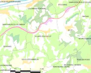
Villars-sous-Écot
- commune in Doubs, France
Hiking in Villars-sous-Écot
Villars-sous-Écot is a charming village located in the French region of Bourgogne-Franche-Comté, near the border with Switzerland. The area is known for its picturesque landscapes and diverse hiking opportunities, making it a great destination for outdoor enthusiasts....
- Country:
- Postal Code: 25150
- Coordinates: 47° 25' 18" N, 6° 41' 57" E
- GPS tracks (wikiloc): [Link]
- Area: 11.48 sq km
- Population: 356
- Web site: [Link]


Saint-Maurice-Colombier
- commune in Doubs, France
Hiking in Saint-Maurice-Colombier
Saint-Maurice-Colombier is located in the Doubs department in the Bourgogne-Franche-Comté region of France. It offers a picturesque backdrop for hikers, characterized by beautiful landscapes, dense forests, and rolling hills....
- Country:
- Postal Code: 25260
- Coordinates: 47° 26' 31" N, 6° 38' 41" E
- GPS tracks (wikiloc): [Link]
- AboveSeaLevel: 330 м m
- Area: 13.29 sq km
- Population: 907
- Web site: [Link]

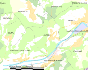
Lougres
- commune in Doubs, France
Hiking in Lougres
It seems like there may be a small confusion with the name "Lougres." As of my last training data cut-off in October 2023, there isn't a widely known hiking destination by that name. However, if you're referring to the region of Lugares or perhaps a specific location in Europe or elsewhere that sounds similar, please clarify for more detailed advice....
- Country:
- Postal Code: 25260
- Coordinates: 47° 28' 18" N, 6° 41' 12" E
- GPS tracks (wikiloc): [Link]
- Area: 5.97 sq km
- Population: 774
- Web site: [Link]