Condorcet (Condorcet)

- commune in Drôme, France
 Hiking in Condorcet
Condorcet, located in the Drôme department of France, offers a beautiful setting for hiking enthusiasts. This charming village is surrounded by stunning natural landscapes, including rolling hills, vineyards, and the dramatic backdrop of the Vercors Mountains. Here’s what you can expect when exploring the hiking opportunities in and around Condorcet:
Trails and Routes
-
Diverse Terrain: The area features a mix of terrains, including forest paths, rocky trails, and gentle slopes that are suitable for hikers of all levels. You can find easy walks for families as well as more challenging hikes for experienced trekkers.
-
Marked Paths: Many trails in the region are marked and well-maintained. It’s advisable to have a hiking map or use a GPS app to navigate the routes easily.
-
Views and Landscape: Hiking around Condorcet gives you incredible views of the surrounding countryside, vineyards, and the distant mountains. The scenery is especially beautiful during the spring and fall when the landscape is vibrant with colors.
Recommended Hiking Areas
- The Dentelles de Montmirail: A bit further from Condorcet, this area offers striking limestone ridges and several hiking trails that provide panoramic views of the region.
- Vercors Regional Natural Park: Located to the southeast, this park is known for its impressive cliffs and diverse wildlife, making it a great spot for hiking and exploring nature.
Local Attractions
- Château de Condorcet: While hiking, take the time to visit the Château, which adds a historical aspect to your outdoor adventure.
- Local Vineyards: The region is known for its wines, so after hiking, consider visiting a vineyard for a tasting experience.
Tips for Hiking in Condorcet
- Best Time to Visit: Spring (April to June) and fall (September to October) are ideal times for hiking, as the weather is generally mild and the trails are not crowded.
- Packing Essentials: Be sure to wear sturdy hiking shoes, bring plenty of water, snacks, a first aid kit, and sun protection.
- Check Weather Conditions: The weather can change rapidly in mountainous areas, so check forecasts before heading out.
Hiking Groups and Guides
If you're new to the area or hiking in general, consider joining a local hiking group or hiring a guide to enhance your experience and ensure safety.
Whether you’re looking for a leisurely walk among vineyards or a challenging ascent in the nearby mountains, Condorcet and the Drôme region have plenty to offer for every hiking adventure. Enjoy your hike!
- Country:

- Postal Code: 26110
- Coordinates: 44° 24' 28" N, 5° 12' 1" E


- GPS tracks (wikiloc): [Link]
- Area: 22.44 sq km
- Population: 474
- Web site: http://www.condorcet-village.fr/
- Wikipedia en: wiki(en)
- Wikipedia: wiki(fr)
- Wikidata storage: Wikidata: Q766142
- Wikipedia Commons Category: [Link]
- Freebase ID: [/m/03mhg0h]
- GeoNames ID: Alt: [6616248]
- SIREN number: [212601033]
- BnF ID: [15252964f]
- VIAF ID: Alt: [245811511]
- INSEE municipality code: 26103
Shares border with regions:
Teyssières
- commune in Drôme, France
Hiking in Teyssières
Teyssières is a beautiful area located in the Drôme department of France, known for its stunning natural landscapes and outdoor activities, including hiking. Hiking in Teyssières offers a variety of trails that cater to different skill levels, making it a great destination for both novice and experienced hikers....
- Country:
- Postal Code: 26220
- Coordinates: 44° 27' 41" N, 5° 8' 45" E
- GPS tracks (wikiloc): [Link]
- Area: 28.09 sq km
- Population: 82


Aubres
- commune in Drôme, France
Hiking in Aubres
Aubres, a picturesque village located in the Drôme department of the Auvergne-Rhône-Alpes region in southeastern France, offers a variety of hiking opportunities that showcase the stunning natural beauty and rich cultural heritage of the area....
- Country:
- Postal Code: 26110
- Coordinates: 44° 22' 37" N, 5° 10' 5" E
- GPS tracks (wikiloc): [Link]
- Area: 20.27 sq km
- Population: 414

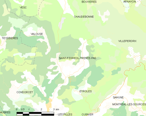
Saint-Ferréol-Trente-Pas
- commune in Drôme, France
Hiking in Saint-Ferréol-Trente-Pas
Saint-Ferréol-Trente-Pas is located in the beautiful region of Occitanie in France, nestled in the foothills of the Pyrenees. The area offers a variety of hiking opportunities for both beginners and experienced hikers. Here's what you can expect when hiking in and around Saint-Ferréol-Trente-Pas:...
- Country:
- Postal Code: 26110
- Coordinates: 44° 25' 37" N, 5° 13' 3" E
- GPS tracks (wikiloc): [Link]
- Area: 21.48 sq km
- Population: 236


Les Pilles
- commune in Drôme, France
Hiking in Les Pilles
Les Pilles is a beautiful area located in the Vaucluse region of France, known for its stunning natural landscapes and varied hiking opportunities. Here are some key points to consider when planning a hiking trip in Les Pilles:...
- Country:
- Postal Code: 26110
- Coordinates: 44° 22' 46" N, 5° 11' 26" E
- GPS tracks (wikiloc): [Link]
- Area: 5.84 sq km
- Population: 246

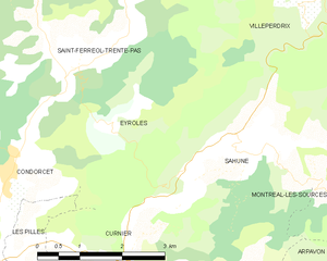
Eyroles
- commune in Drôme, France
Hiking in Eyroles
Eyroles is a picturesque area located in the southern part of France, known for its stunning landscapes and varied hiking opportunities. While it may not be as famous as some other regions in France, it offers charming trails suitable for all levels of hikers....
- Country:
- Postal Code: 26110
- Coordinates: 44° 25' 2" N, 5° 13' 36" E
- GPS tracks (wikiloc): [Link]
- Area: 8.75 sq km
- Population: 33