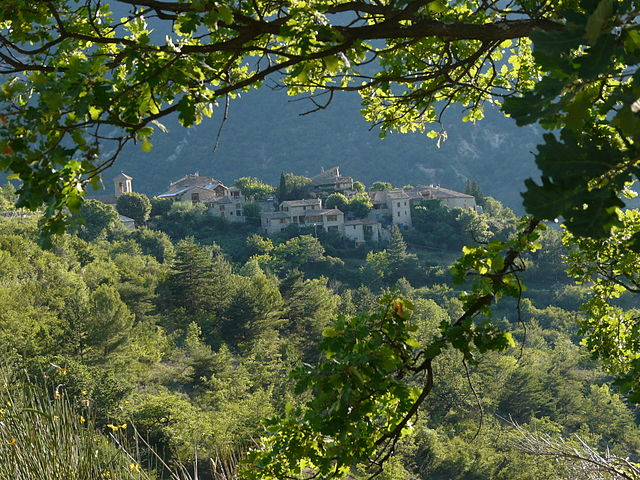
Les Pilles (Les Pilles)

- commune in Drôme, France
 Hiking in Les Pilles
Les Pilles is a beautiful area located in the Vaucluse region of France, known for its stunning natural landscapes and varied hiking opportunities. Here are some key points to consider when planning a hiking trip in Les Pilles:
Scenic Trails
- Variety of Trails: Les Pilles offers a range of hiking trails suitable for different skill levels, from gentle walks to more challenging hikes.
- Breathtaking Views: Many trails in the area provide spectacular views of the surrounding countryside, vineyards, and the iconic Mont Ventoux in the distance.
Natural Features
- Flora and Fauna: The region is rich in biodiversity, featuring lush plant life, wildflowers, and a variety of wildlife. Keep an eye out for local species and enjoy the peacefulness of nature.
- Geological Formations: The area is also known for its unique geological features, including rock formations and hills that make for interesting hiking experiences.
Accessibility
- Trail Markings: Most of the trails are well-marked with signage, making navigation easier for hikers.
- Seasonal Considerations: Spring and fall are ideal times for hiking in Les Pilles due to mild weather. Summer can be hot, while winter may bring snow in higher areas.
Local Attractions
- Cultural Sites: While hiking, you may encounter charming villages, vineyards, and historical sites that add cultural depth to your experience.
- Harvest Time: If you're hiking in the fall, consider timing your visit to coincide with grape harvest season for a unique local experience.
Tips for Hiking
- Preparation: Always check the weather forecast and dress in layers. Carry enough water, snacks, and a hiking map or a GPS device.
- Leave No Trace: Practice responsible hiking by staying on marked trails, respecting wildlife, and carrying out any trash.
- Safety: Inform someone of your hiking plans and estimated return time, especially if heading into more remote areas.
Conclusion
Hiking in Les Pilles provides an excellent opportunity to escape into nature, enjoy stunning landscapes, and experience the beauty of the Vaucluse region. Whether you’re a seasoned hiker or a casual walker, the area has something to offer everyone.
- Country:

- Postal Code: 26110
- Coordinates: 44° 22' 46" N, 5° 11' 26" E


- GPS tracks (wikiloc): [Link]
- Area: 5.84 sq km
- Population: 246
- Wikipedia en: wiki(en)
- Wikipedia: wiki(fr)
- Wikidata storage: Wikidata: Q666535
- Wikipedia Commons Category: [Link]
- Freebase ID: [/m/03mgkmx]
- GeoNames ID: Alt: [6455744]
- SIREN number: [212602387]
- BnF ID: [15253098h]
- INSEE municipality code: 26238
Shares border with regions:

Montaulieu
- commune in Drôme, France
Hiking in Montaulieu
Montaulieu, located in the Vaucluse region of France, offers a variety of hiking opportunities that cater to different skill levels. The area is known for its beautiful landscapes, including hills, forests, and panoramic views of the surrounding countryside. Here are some key points about hiking in Montaulieu:...
- Country:
- Postal Code: 26110
- Coordinates: 44° 21' 28" N, 5° 13' 26" E
- GPS tracks (wikiloc): [Link]
- Area: 13.05 sq km
- Population: 82
- Web site: [Link]


Curnier
- commune in Drôme, France
Hiking in Curnier
Curnier is a picturesque village located in the Jura Mountains of Switzerland. This region is known for its stunning landscapes, rich biodiversity, and well-marked hiking trails that cater to various skill levels. Here’s what you can expect when hiking in and around Curnier:...
- Country:
- Postal Code: 26110
- Coordinates: 44° 23' 6" N, 5° 14' 4" E
- GPS tracks (wikiloc): [Link]
- Area: 8 sq km
- Population: 177

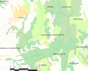
Châteauneuf-de-Bordette
- commune in Drôme, France
Hiking in Châteauneuf-de-Bordette
Châteauneuf-de-Bordette is a small commune located in the Drôme department of southeastern France. The area is known for its picturesque landscapes, rolling hills, and access to the beautiful natural scenery of the Vercors Regional Natural Park, which offers numerous opportunities for hiking and outdoor activities....
- Country:
- Postal Code: 26110
- Coordinates: 44° 20' 8" N, 5° 10' 41" E
- GPS tracks (wikiloc): [Link]
- Area: 15.33 sq km
- Population: 93


Aubres
- commune in Drôme, France
Hiking in Aubres
Aubres, a picturesque village located in the Drôme department of the Auvergne-Rhône-Alpes region in southeastern France, offers a variety of hiking opportunities that showcase the stunning natural beauty and rich cultural heritage of the area....
- Country:
- Postal Code: 26110
- Coordinates: 44° 22' 37" N, 5° 10' 5" E
- GPS tracks (wikiloc): [Link]
- Area: 20.27 sq km
- Population: 414
Condorcet
- commune in Drôme, France
Hiking in Condorcet
Condorcet, located in the Drôme department of France, offers a beautiful setting for hiking enthusiasts. This charming village is surrounded by stunning natural landscapes, including rolling hills, vineyards, and the dramatic backdrop of the Vercors Mountains. Here’s what you can expect when exploring the hiking opportunities in and around Condorcet:...
- Country:
- Postal Code: 26110
- Coordinates: 44° 24' 28" N, 5° 12' 1" E
- GPS tracks (wikiloc): [Link]
- Area: 22.44 sq km
- Population: 474
- Web site: [Link]

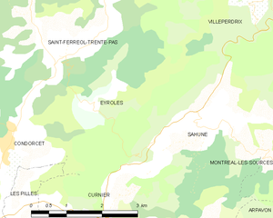
Eyroles
- commune in Drôme, France
Hiking in Eyroles
Eyroles is a picturesque area located in the southern part of France, known for its stunning landscapes and varied hiking opportunities. While it may not be as famous as some other regions in France, it offers charming trails suitable for all levels of hikers....
- Country:
- Postal Code: 26110
- Coordinates: 44° 25' 2" N, 5° 13' 36" E
- GPS tracks (wikiloc): [Link]
- Area: 8.75 sq km
- Population: 33