Corbel, Savoie (Corbel)

- commune in Savoie, France
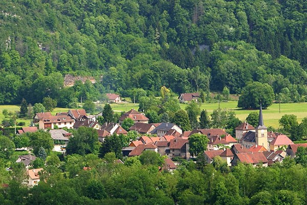
 Hiking in Corbel, Savoie
Corbel is a small commune located in the Savoie department of the Auvergne-Rhône-Alpes region in southeastern France. Nestled in the charming French Alps, Corbel offers a picturesque setting for hiking enthusiasts, featuring stunning mountain landscapes, dense forests, and beautiful alpine meadows.
Hiking Opportunities:
-
Scenic Trails: The region is home to a variety of trails that cater to different skill levels, from easy walks for beginners to more challenging hikes for experienced adventurers. The trails often provide panoramic views of the surrounding mountains and valleys.
-
Natural Attractions: Hikers can enjoy the area's natural beauty, including rivers, waterfalls, and diverse wildlife. Look out for opportunities to see local flora and fauna, as the region is rich in biodiversity.
-
Cultural Sites: In addition to natural hikes, there are routes that lead to historical sites, chapels, and traditional alpine villages, allowing you to experience the cultural heritage of the area.
Tips for Hiking in Corbel:
-
Timing: The best time for hiking in this region is during the late spring to early fall (May to October) when the weather is generally milder and the trails are more accessible.
-
Preparation: Ensure you have the appropriate gear, including sturdy hiking boots, water, snacks, and a map or GPS device. Weather conditions can change rapidly in the mountains, so layers of clothing are advisable.
-
Local Guidelines: Check for any local regulations or guidelines concerning trail use, particularly if you plan to hike in protected areas.
-
Guided Tours: If you're unfamiliar with the area, consider participating in a guided hike. Local guides can provide valuable insights into the geography, history, and ecology of the region.
Conclusion:
Hiking in Corbel, Savoie, offers a great opportunity to explore the stunning landscapes of the French Alps while enjoying a variety of trails suitable for all levels. Always remember to respect the environment and leave no trace to preserve this beautiful area for future hikers. Enjoy your adventure!
- Country:

- Postal Code: 73160
- Coordinates: 45° 25' 46" N, 5° 49' 31" E


- GPS tracks (wikiloc): [Link]
- Area: 10.31 sq km
- Population: 157
- Web site: http://www.corbel.fr/
- Wikipedia en: wiki(en)
- Wikipedia: wiki(fr)
- Wikidata storage: Wikidata: Q582139
- Wikipedia Commons Category: [Link]
- Freebase ID: [/m/03m8lbp]
- GeoNames ID: Alt: [6451003]
- SIREN number: [217300920]
- BnF ID: [152740269]
- WOEID: [586919]
- INSEE municipality code: 73092
Shares border with regions:

Saint-Christophe-sur-Guiers
- commune in Isère, France
Hiking in Saint-Christophe-sur-Guiers
Saint-Christophe-sur-Guiers is a charming village located in the Isère department of the Auvergne-Rhône-Alpes region in southeastern France. The area is surrounded by stunning natural landscapes, making it a great destination for hiking enthusiasts....
- Country:
- Postal Code: 38380
- Coordinates: 45° 26' 19" N, 5° 46' 26" E
- GPS tracks (wikiloc): [Link]
- Area: 23.54 sq km
- Population: 858
- Web site: [Link]

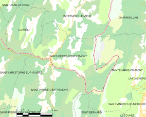
Saint-Pierre-d'Entremont
- commune in Savoie, France
Hiking in Saint-Pierre-d'Entremont
Saint-Pierre-d'Entremont, located in the Savoie region of the French Alps, offers a wealth of hiking opportunities amidst stunning natural scenery. The area is nestled between majestic mountains and lush green valleys, making it an ideal destination for nature lovers and outdoor enthusiasts....
- Country:
- Postal Code: 73670
- Coordinates: 45° 25' 2" N, 5° 51' 15" E
- GPS tracks (wikiloc): [Link]
- Area: 18.36 sq km
- Population: 426


Saint-Christophe
- commune in Savoie, France
Hiking in Saint-Christophe
Saint-Christophe in Savoie is a beautiful destination for hiking enthusiasts. Nestled in the French Alps, this area offers stunning landscapes, including mountains, forests, and alpine meadows. Here’s what you can expect when hiking in Saint-Christophe:...
- Country:
- Postal Code: 73360
- Coordinates: 45° 27' 2" N, 5° 46' 32" E
- GPS tracks (wikiloc): [Link]
- Area: 11.01 sq km
- Population: 529
- Web site: [Link]


Saint-Jean-de-Couz
- commune in Savoie, France
Hiking in Saint-Jean-de-Couz
Saint-Jean-de-Couz is a charming commune located in the Savoie department of the Auvergne-Rhône-Alpes region in southeastern France. It's nestled at the foot of the Alps, making it an excellent destination for hiking enthusiasts, particularly those who are looking to explore the beautiful landscapes of the French Alps....
- Country:
- Postal Code: 73160
- Coordinates: 45° 28' 2" N, 5° 49' 6" E
- GPS tracks (wikiloc): [Link]
- Area: 7.71 sq km
- Population: 286


Entremont-le-Vieux
- commune in Savoie, France
Hiking in Entremont-le-Vieux
Entremont-le-Vieux is a charming commune located in the Savoie region of the French Alps, known for its stunning natural surroundings and outdoor recreational opportunities, including hiking. The area offers a variety of trails suitable for different skill levels, making it an excellent destination for hikers of all backgrounds....
- Country:
- Postal Code: 73670
- Coordinates: 45° 27' 7" N, 5° 53' 3" E
- GPS tracks (wikiloc): [Link]
- Area: 33.01 sq km
- Population: 654