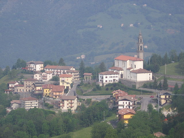
Cornalba (Cornalba)
.svg)
- Italian comune
 Hiking in Cornalba
Cornalba is a picturesque village located in the Lombardy region of Italy, nestled in the Bergamo Alps. Its stunning landscapes, lush forests, and scenic views make it a fantastic destination for hiking enthusiasts. Here’s what you need to know about hiking in and around Cornalba:
Trails and Scenery
-
Diverse Terrain: The area around Cornalba offers a variety of trails suitable for different skill levels, from easy walks to challenging hikes. The paths navigate through forests, meadows, and mountainous terrain.
-
Recommended Trails:
- Sentiero dei Fiori: A popular trail that offers breathtaking views of the surrounding mountains and is adorned with beautiful wildflowers throughout the season.
- Monte Rena: A more challenging hike that takes you to the peak, providing panoramic views of the region. This trail is great for those looking for a bit of adventure and a chance to see the local wildlife.
- Valle San Martino: A scenic route that allows hikers to explore deeper into nature, often with fewer crowds.
-
Nature Observation: The area is rich in biodiversity. Keep an eye out for various species of birds, butterflies, and possibly even deer while hiking.
Practical Information
-
Best Time to Hike: The best time for hiking in Cornalba is during late spring to early autumn (May to October). However, be aware that weather can change rapidly in mountainous regions, so it’s essential to check forecasts before heading out.
-
Equipment: Good hiking boots, weather-appropriate clothing, and enough water and snacks are essential. A map or hiking app can be helpful, as some trails may not be well-marked.
-
Local Regulations: Always follow local guidelines regarding trail use, wildlife protection, and camping rules if you plan to stay overnight.
Getting There
Cornalba is accessible by public transport from cities like Bergamo. Alternatively, a personal vehicle is a convenient option for exploring more remote trails around the area.
Conclusion
Hiking in Cornalba offers a wonderful opportunity to experience the natural beauty of Italy's Alpine region. Whether you are a novice or an experienced hiker, you’ll find something that suits your preferences in this beautiful locale. Make sure to respect the environment and enjoy your adventure!
- Country:

- Postal Code: 24017
- Local Dialing Code: 0345
- Licence Plate Code: BG
- Coordinates: 45° 51' 0" N, 9° 45' 0" E


- GPS tracks (wikiloc): [Link]
- AboveSeaLevel: 893 м m
- Area: 9.25 sq km
- Population: 305
- Web site: http://www.comune.cornalba.bg.it/
- Wikipedia en: wiki(en)
- Wikipedia: wiki(it)
- Wikidata storage: Wikidata: Q100410
- Wikipedia Commons Gallery: [Link]
- Wikipedia Commons Category: [Link]
- Freebase ID: [/m/0gjg0g]
- GeoNames ID: Alt: [6537160]
- VIAF ID: Alt: [244268804]
- OSM relation ID: [46309]
- ISTAT ID: 016249
- Italian cadastre code: D016
Shares border with regions:

Costa di Serina
- Italian comune
Hiking in Costa di Serina
Costa Serina, located in the province of Bergamo in the Lombardy region of Italy, is a beautiful destination for hiking enthusiasts. Nestled in the scenic foothills of the Alps, it offers a variety of trails that cater to different levels of experience, from casual walkers to seasoned hikers. Here are some key details about hiking in this area:...
- Country:
- Postal Code: 24010
- Local Dialing Code: 0345
- Licence Plate Code: BG
- Coordinates: 45° 49' 58" N, 9° 44' 30" E
- GPS tracks (wikiloc): [Link]
- AboveSeaLevel: 868 м m
- Area: 12.3 sq km
- Population: 912
- Web site: [Link]


Gazzaniga
- Italian comune
Hiking in Gazzaniga
Gazzaniga, a town located in the Lombardy region of Italy, is surrounded by beautiful natural landscapes that provide fantastic opportunities for hiking enthusiasts. While the town itself may not be a well-known hiking destination, its proximity to the Orobian Alps and the Seriana Valley offers a variety of trails suitable for all levels of hikers....
- Country:
- Postal Code: 24025
- Local Dialing Code: 035
- Licence Plate Code: BG
- Coordinates: 45° 48' 0" N, 9° 50' 0" E
- GPS tracks (wikiloc): [Link]
- AboveSeaLevel: 386 м m
- Area: 14.41 sq km
- Population: 5058
- Web site: [Link]


Oltre il Colle
- Italian comune
Hiking in Oltre il Colle
Oltre il Colle is a beautiful destination for hiking enthusiasts, located in the Seriana Valley in Italy, close to Bergamo. Known for its stunning landscapes, the area offers a range of trails suitable for various skill levels, from leisurely walks to more challenging hikes....
- Country:
- Postal Code: 24013
- Local Dialing Code: 0345
- Licence Plate Code: BG
- Coordinates: 45° 53' 0" N, 9° 46' 0" E
- GPS tracks (wikiloc): [Link]
- AboveSeaLevel: 1030 м m
- Area: 32.89 sq km
- Population: 1004
- Web site: [Link]


Oneta, Lombardy
- Italian comune
Hiking in Oneta, Lombardy
Oneta, located in the Lombardy region of Italy, is a picturesque village nestled within the Orobian Alps, making it an excellent spot for hiking enthusiasts. The area boasts stunning landscapes, including lush forests, rocky terrains, and panoramic views of the surrounding mountains....
- Country:
- Postal Code: 24020
- Local Dialing Code: 035
- Licence Plate Code: BG
- Coordinates: 45° 52' 0" N, 9° 49' 0" E
- GPS tracks (wikiloc): [Link]
- AboveSeaLevel: 740 м m
- Area: 18.66 sq km
- Population: 598
- Web site: [Link]


Serina, Lombardy
- Italian comune
Hiking in Serina, Lombardy
Serina, located in the Lombardy region of Italy, is a beautiful area for hiking enthusiasts. Nestled in the Seriana Valley, Serina offers stunning landscapes characterized by lush forests, rocky escarpments, and panoramic views of the surrounding mountains. Here are some key points to consider if you're planning a hiking trip to Serina:...
- Country:
- Postal Code: 24017
- Local Dialing Code: 0345
- Licence Plate Code: BG
- Coordinates: 45° 52' 0" N, 9° 44' 0" E
- GPS tracks (wikiloc): [Link]
- AboveSeaLevel: 720 м m
- Area: 27.34 sq km
- Population: 2077
- Web site: [Link]


Vertova
- Italian comune
Hiking in Vertova
Vertova is a charming town located in the Bergamo province of Lombardy, Italy, surrounded by picturesque mountains and beautiful landscapes, making it an appealing spot for hikers. The area is characterized by its rich natural beauty, featuring forests, rivers, and stunning views of the surrounding Alps....
- Country:
- Postal Code: 24029
- Local Dialing Code: 035
- Licence Plate Code: BG
- Coordinates: 45° 49' 0" N, 9° 51' 0" E
- GPS tracks (wikiloc): [Link]
- AboveSeaLevel: 397 м m
- Area: 15.69 sq km
- Population: 4642
- Web site: [Link]