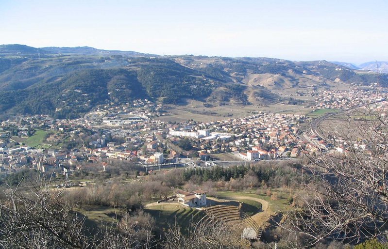
Cornas (Cornas)
- commune in Ardèche, France
 Hiking in Cornas
Cornas is a charming commune located in the Rhône department of France, known primarily for its picturesque vineyards that produce some exquisite red wines, particularly Syrah. The region offers excellent opportunities for hiking enthusiasts, combining stunning natural landscapes with the rich cultural heritage of the area.
Hiking Trails:
-
Sentier des Vignes: This trail takes you through the vineyards that are synonymous with the Cornas wine region. The path offers breathtaking views of the vineyards and the Rhône Valley, allowing hikers to appreciate the beauty of the terraced landscapes.
-
Col de l'Escrinet: A bit farther from Cornas, this trail offers a more challenging hike with rewarding views. The trail leads through lush forests and scenic overlooks, providing a great opportunity to experience the local flora and fauna.
-
The Doux Valley: This area is known for its gentle paths along the Doux River, ideal for those looking for a relaxing trek surrounded by nature. This area is particularly beautiful during the spring when the wildflowers are in bloom.
Tips for Hiking in Cornas:
- Season: The best times to hike in this region are during the spring (April to June) and fall (September to October) when temperatures are mild and the landscapes are particularly stunning.
- Trail Conditions: Always check trail conditions before heading out, especially after heavy rain, as some paths might become muddy or slippery.
- Local Regulations: Be respectful of vineyard property and local wildlife. Stick to designated trails and be mindful of your impact on the environment.
- Hydration and Supplies: Bring plenty of water, snacks, and a map or GPS device, as some areas might not have cell service.
Enjoying the Region:
After a good hike, consider stopping by one of the local wineries to sample the renowned Cornas wines and enjoy the regional cuisine in nearby restaurants. The blend of outdoor adventure and culinary exploration makes for a perfect day in this beautiful part of France!
- Country:

- Postal Code: 07130
- Coordinates: 44° 57' 50" N, 4° 50' 54" E


- GPS tracks (wikiloc): [Link]
- Area: 8.33 sq km
- Population: 2213
- Web site: http://www.cornas.fr
- Wikipedia en: wiki(en)
- Wikipedia: wiki(fr)
- Wikidata storage: Wikidata: Q271351
- Wikipedia Commons Category: [Link]
- Freebase ID: [/m/0b88_q]
- GeoNames ID: Alt: [6453478]
- SIREN number: [210700704]
- VIAF ID: Alt: [236183915]
- MusicBrainz area ID: [fe28d3e9-f709-4992-8c62-fc8080233e0a]
- INSEE municipality code: 07070
Shares border with regions:


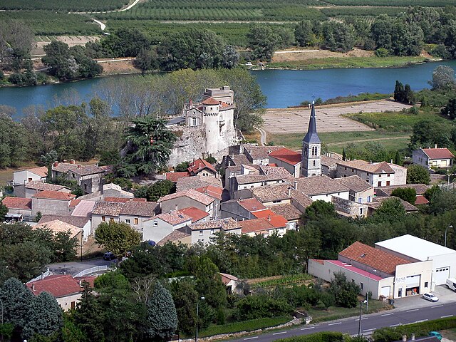
La Roche-de-Glun
- commune in Drôme, France
Hiking in La Roche-de-Glun
La Roche-de-Glun, located in the Drôme department of the Auvergne-Rhône-Alpes region in southeastern France, offers various hiking opportunities that highlight its natural beauty and scenic landscapes. Here are some key points about hiking in this area:...
- Country:
- Postal Code: 26600
- Coordinates: 45° 0' 43" N, 4° 50' 51" E
- GPS tracks (wikiloc): [Link]
- Area: 12.79 sq km
- Population: 3258
- Web site: [Link]
Saint-Péray
- commune in Ardèche, France
Hiking in Saint-Péray
Saint-Péray, located in the Auvergne-Rhône-Alpes region of France, is a charming destination for hiking enthusiasts. Nestled near the Rhône River and surrounded by picturesque vineyards and rolling hills, it offers a variety of trails that cater to different skill levels....
- Country:
- Postal Code: 07130
- Coordinates: 44° 56' 55" N, 4° 50' 42" E
- GPS tracks (wikiloc): [Link]
- AboveSeaLevel: 128 м m
- Area: 24.05 sq km
- Population: 7572
- Web site: [Link]


Bourg-lès-Valence
- commune in Drôme, France
Hiking in Bourg-lès-Valence
Bourg-lès-Valence is a charming town located in the Auvergne-Rhône-Alpes region of France, situated near the banks of the Rhône River. While it may not be a major hiking destination in itself, its proximity to the surrounding natural landscapes makes it a great starting point for various hiking opportunities....
- Country:
- Postal Code: 26500
- Coordinates: 44° 56' 51" N, 4° 53' 43" E
- GPS tracks (wikiloc): [Link]
- Area: 20.3 sq km
- Population: 20074
- Web site: [Link]
Châteaubourg
- commune in Ardèche, France
Hiking in Châteaubourg
Châteaubourg, located in the Ardèche department of France, is nestled in a region known for its stunning landscapes, picturesque villages, and diverse hiking trails. The Ardèche is famous for its dramatic gorges, limestone cliffs, and forested areas, making it a fantastic destination for hikers of all levels....
- Country:
- Postal Code: 07130
- Coordinates: 44° 59' 49" N, 4° 50' 37" E
- GPS tracks (wikiloc): [Link]
- Area: 4.27 sq km
- Population: 234

Saint-Romain-de-Lerps
- commune in Ardèche, France
- Country:
- Postal Code: 07130
- Coordinates: 44° 58' 44" N, 4° 47' 48" E
- GPS tracks (wikiloc): [Link]
- Area: 14.14 sq km
- Population: 838