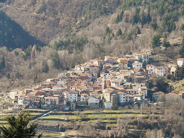
Cosio di Arroscia (Cosio di Arroscia)
- Italian comune
Cosio di Arroscia is a picturesque village located in the province of Imperia, in the Liguria region of Italy. It’s nestled in the Arroscia Valley and is surrounded by beautiful natural landscapes, making it a great spot for hiking enthusiasts seeking serene trails and stunning views.
Hiking Trails
There are several hiking trails in and around Cosio di Arroscia, ranging from easy walks to more challenging routes. Here are some options to consider:
-
Sentiero dei Muratori: This is a historical trail that takes you through the local area while showcasing traditional stone structures. It offers insights into the local culture and allows hikers to enjoy the scenic beauty of the valley.
-
Monte Faudo: A popular hike that leads to the summit of Monte Faudo, offering panoramic views of the surrounding mountains and the sea on clear days. The trail can be steep in sections, so it’s recommended for those with a moderate fitness level.
-
Valle Arroscia Loop: This is an excellent option for those looking to explore the valley itself. The loop trail offers varying terrain and the chance to see local flora and fauna, ideal for nature lovers.
Preparation Tips
- Weather: Check the weather conditions before heading out, as they can change rapidly in mountainous areas.
- Footwear: Wear proper hiking boots to ensure stability and comfort on the trails.
- Water and Snacks: Bring enough water and some snacks, especially for longer hikes.
- Map and Compass: While many trails are well-marked, carrying a map and compass (or a GPS device) can be helpful, especially if you plan to explore less-trafficked routes.
Local Attractions
After a day of hiking, you might want to explore the local area. Cosio di Arroscia has charming architecture, local eateries serving traditional Ligurian dishes, and friendly locals. It’s also close to other beautiful towns such as Badalucco and Taggia, which are worth a visit.
Conclusion
Hiking in Cosio di Arroscia is a rewarding experience that combines natural beauty with cultural richness. Whether you’re looking for a leisurely walk or a challenging hike, you’ll find something that suits your preferences in this beautiful corner of Italy.
- Country:

- Postal Code: 18023
- Local Dialing Code: 0183
- Licence Plate Code: IM
- Coordinates: 44° 4' 32" N, 7° 49' 52" E


- GPS tracks (wikiloc): [Link]
- AboveSeaLevel: 721 м m
- Area: 40.56 sq km
- Population: 204
- Web site: http://www.comunecosiodiarroscia.info/
- Wikipedia en: wiki(en)
- Wikipedia: wiki(it)
- Wikidata storage: Wikidata: Q268742
- Wikipedia Commons Category: [Link]
- Freebase ID: [/m/0gbyjx]
- GeoNames ID: Alt: [6542429]
- VIAF ID: Alt: [245420131]
- OSM relation ID: [42841]
- ISTAT ID: 008023
- Italian cadastre code: D087
Shares border with regions:

Briga Alta
- Italian comune
Briga Alta is a charming town located in the Piedmont region of northern Italy, known for its beautiful landscapes, historical significance, and excellent hiking opportunities. If you're considering hiking in that area, here are some details to keep in mind:...
- Country:

- Postal Code: 18025
- Local Dialing Code: 0174
- Licence Plate Code: CN
- Coordinates: 44° 4' 53" N, 7° 44' 27" E


- GPS tracks (wikiloc): [Link]
- AboveSeaLevel: 1310 м m
- Area: 52.18 sq km
- Population: 40
- Web site: [Link]

Ormea
- Italian comune
Ormea, located in the Liguria region of Italy, is a hidden gem for hiking enthusiasts. Nestled in the Maritime Alps, this charming town offers breathtaking landscapes, rich biodiversity, and a variety of trails suitable for all experience levels. Here are some key points about hiking in and around Ormea:...
- Country:

- Postal Code: 12078
- Local Dialing Code: 0174
- Licence Plate Code: CN
- Coordinates: 44° 9' 0" N, 7° 55' 0" E


- GPS tracks (wikiloc): [Link]
- AboveSeaLevel: 740 м m
- Area: 124.5 sq km
- Population: 1607
- Web site: [Link]


Mendatica
- Italian comune
Mendatica is a charming village in the Ligurian region of Italy, known for its picturesque landscapes and rich natural beauty, making it an excellent destination for hiking enthusiasts. The area is characterized by rugged mountains, dense forests, and scenic valleys, providing a variety of trails suitable for different skill levels....
- Country:

- Postal Code: 18025
- Local Dialing Code: 0183
- Licence Plate Code: IM
- Coordinates: 44° 4' 35" N, 7° 48' 20" E


- GPS tracks (wikiloc): [Link]
- AboveSeaLevel: 778 м m
- Area: 30.69 sq km
- Population: 187
- Web site: [Link]


Pornassio
- Italian comune
Pornassio is a charming village located in the Liguria region of Italy, nestled in the beautiful mountains of the Apennines. It's an excellent base for hiking enthusiasts looking to explore the natural beauty of the area. Here are some highlights for hiking in and around Pornassio:...
- Country:

- Postal Code: 18024
- Local Dialing Code: 0183
- Licence Plate Code: IM
- Coordinates: 44° 4' 12" N, 7° 52' 10" E


- GPS tracks (wikiloc): [Link]
- AboveSeaLevel: 630 м m
- Area: 27.21 sq km
- Population: 681
- Web site: [Link]


Montegrosso Pian Latte
- Italian comune
 Hiking in Montegrosso Pian Latte
Montegrosso Pian Latte is a charming village located in the province of Imperia, in the Italian Liguria region. Nestled in the foothills of the Alps, it offers an array of stunning landscapes, rich biodiversity, and various hiking trails suitable for different skill levels. Here are some key points to consider if you're planning to hike in Montegrosso Pian Latte:...
- Country:

- Postal Code: 18025
- Local Dialing Code: 0183
- Licence Plate Code: IM
- Coordinates: 44° 4' 0" N, 7° 49' 4" E


- GPS tracks (wikiloc): [Link]
- AboveSeaLevel: 721 м m
- Area: 10.03 sq km
- Population: 124
- Web site: [Link]
