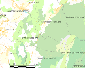
Coublevie (Coublevie)
- commune in Isère, France
Coublevie is a charming village located in the Auvergne-Rhône-Alpes region of France, set near the foothills of the Alps. This region offers a variety of hiking opportunities for outdoor enthusiasts. Here are some key points to consider when hiking in and around Coublevie:
Trails and Routes
-
Local Trails: There are several marked trails around Coublevie that cater to different skill levels, ranging from easy walks suitable for families to more challenging hikes for seasoned trekkers.
-
Nature Enjoyment: The hikes typically showcase beautiful natural landscapes featuring forests, rivers, and panoramic views of the surrounding mountains.
-
Elevation Variation: Some trails may involve significant elevation changes, allowing hikers to experience stunning vistas of the Alps and the surrounding valleys.
-
Cultural Sites: Some hiking routes may take you past historical sites, such as old chapels or traditional farms, enhancing your experience with cultural insights.
Preparation
- Gear: Ensure you're equipped with suitable hiking boots, weather-appropriate clothing, a backpack, water, and snacks.
- Maps: While many trails are well-marked, it's wise to carry a physical map or have a hiking app for navigation.
- Weather Awareness: Weather in the mountains can change rapidly, so be prepared for variable conditions.
Safety
- Stay on Marked Trails: To minimize the impact on the environment and ensure your safety.
- Inform Someone: Let someone know your hiking plans, especially if you’re going on longer or more challenging hikes.
Local Resources
- Tourist Information: The local tourist office can provide maps, recommendations, and up-to-date information on trails and conditions.
- Guided Tours: For those unfamiliar with the area, consider joining a guided hike to learn more about the region’s flora, fauna, and geological features.
Best Time to Hike
- Spring (April to June): Ideal for blooming flowers and pleasant weather.
- Summer (July to August): Warm weather, but trails can be busier.
- Autumn (September to October): Beautiful fall foliage and fewer crowds.
- Winter (November to March): Some trails may be inaccessible due to snow, but snowshoeing and winter hiking can be enjoyed in the area.
Hiking in Coublevie offers a wonderful way to explore the stunning natural beauty of the French Alps, so get out there and enjoy the trails!
- Country:

- Postal Code: 38500
- Coordinates: 45° 21' 20" N, 5° 37' 0" E


- GPS tracks (wikiloc): [Link]
- Area: 7.05 sq km
- Population: 4680
- Web site: http://www.coublevie.fr
- Wikipedia en: wiki(en)
- Wikipedia: wiki(fr)
- Wikidata storage: Wikidata: Q1069515
- Wikipedia Commons Category: [Link]
- Freebase ID: [/m/03nvhd1]
- GeoNames ID: Alt: [3023381]
- SIREN number: [213801335]
- BnF ID: [152579561]
- MusicBrainz area ID: [0bec3f98-7c32-4046-8ead-edb62879fa3e]
- INSEE municipality code: 38133
Shares border with regions:


Saint-Étienne-de-Crossey
- commune in Isère, France
 Hiking in Saint-Étienne-de-Crossey
Saint-Étienne-de-Crossey is a charming commune located in the Isère department of the Auvergne-Rhône-Alpes region in southeastern France. It is surrounded by stunning natural landscapes, making it a great destination for hiking enthusiasts. Here are some highlights and tips for hiking in this area:...
- Country:

- Postal Code: 38960
- Coordinates: 45° 22' 45" N, 5° 38' 44" E


- GPS tracks (wikiloc): [Link]
- Area: 12.84 sq km
- Population: 2550
- Web site: [Link]


Saint-Jean-de-Moirans
- commune in Isère, France
 Hiking in Saint-Jean-de-Moirans
Saint-Jean-de-Moirans is located in the Auvergne-Rhône-Alpes region of France, nestled at the foot of the Chartreuse Mountains. This picturesque area offers a variety of hiking opportunities that cater to different skill levels, from leisurely walks to more challenging treks....
- Country:

- Postal Code: 38430
- Coordinates: 45° 20' 28" N, 5° 34' 56" E


- GPS tracks (wikiloc): [Link]
- Area: 6.43 sq km
- Population: 3427
- Web site: [Link]


Saint-Julien-de-Raz
- former commune in Isère, France
Saint-Julien-de-Raz is a charming commune in the Vaucluse department of the Provence-Alpes-Côte d'Azur region in southeastern France. Although it's not widely known as a major hiking destination, it offers access to beautiful natural surroundings that are ideal for those interested in exploring the great outdoors....
- Country:

- Postal Code: 38134
- Coordinates: 45° 20' 59" N, 5° 39' 42" E


- GPS tracks (wikiloc): [Link]
- AboveSeaLevel: 630 м m
- Area: 10.81 sq km
- Population: 429
- Web site: [Link]


La Buisse
- commune in Isère, France
La Buisse is a charming village located in the Isère department of the Auvergne-Rhône-Alpes region in France. It serves as a great starting point for hiking enthusiasts looking to explore the natural beauty of the area, particularly the nearby Vercors Regional Natural Park and the Chartreuse Mountains....
- Country:

- Postal Code: 38500
- Coordinates: 45° 20' 6" N, 5° 37' 18" E


- GPS tracks (wikiloc): [Link]
- Area: 11.53 sq km
- Population: 3144
- Web site: [Link]


Voiron
- commune in Isère, France
Voiron, located in the Isère department in the Auvergne-Rhône-Alpes region of France, is surrounded by beautiful natural landscapes, making it an excellent destination for hiking enthusiasts. Here are some highlights about hiking around Voiron:...
- Country:

- Postal Code: 38500
- Coordinates: 45° 21' 48" N, 5° 35' 24" E


- GPS tracks (wikiloc): [Link]
- Area: 21.9 sq km
- Population: 20529
- Web site: [Link]
